Gaithersburg in Montgomery County, Maryland — The American Northeast (Mid-Atlantic)
The Gaithersburg Wye
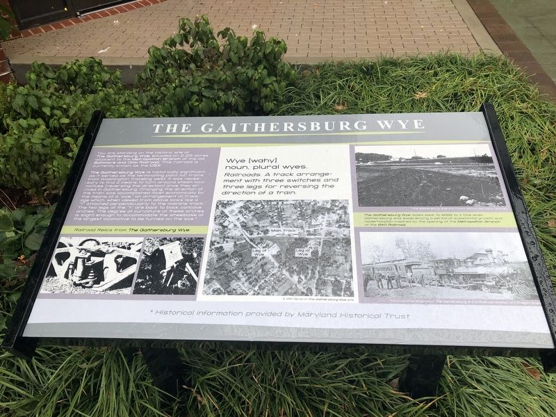
The Gaithersburg Wye is historically significant as it served as the terminating point for trains from Washington traveling west. It was necessary to find a means to turn around steam locomotives (reversing the direction) once they arrived in Gaithersburg. Changing the direction of the train was accomplished most economically by the means of a "wye," an arrangement of trackage which, when viewed from above looks like a "Y" attached perpendicularly to the mainline track. The two legs of the "Y" are back to back concave arches. The degree of curvature of these arches is slight enough to accommodate the wheelbase of the largest locomotive to be turned on the wye.* [Caption:]
Railroad Relics from The Gaithersburg Wye.
Wye [wahy]
noun. plural wyes.
Railroads. A track arrangements with three switches and three legs for reversing the direction of a train.
[Captions:]
The Gaithersburg Wye dates back to 1888 to a time when Gaithersburg was experiencing a period of growth and modernization inspired by the opening of the Metropolitan Branch of the B&O Railroad.
The locomotive stopped at The Gaithersburg B & O Railroad Station and Freight Shed
*Historical
this page online
Topics and series. This historical marker is listed in these topic lists: Railroads & Streetcars • Settlements & Settlers. In addition, it is included in the Baltimore and Ohio Railroad (B&O) series list. A significant historical year for this entry is 1888.
Location. 39° 8.454′ N, 77° 11.754′ W. Marker is in Gaithersburg, Maryland, in Montgomery County. It is on Olde Towne Avenue close to Fulks Corner Avenue, on the right when traveling west. Touch for map. Marker is at or near this postal address: 200 Old Towne Avenue, Gaithersburg MD 20877, United States of America. Touch for directions.

Regionally, this marker is in the Washington Metropolitan Area. It is also in the American Mid-Atlantic. Globally, it is in North America, the Western Hemisphere, the Western World, and the Anglosphere. Historically, it finds itself in what was once one of the original Thirteen Colonies and also the Antebellum South.
Other nearby markers. At least 8 other markers are within walking distance of this marker: DNC Building (about 600 feet away, measured in a direct line); Schwartz House / City Hall
Credits. This page was last revised on October 20, 2019. It was originally submitted on October 20, 2019, by Devry Becker Jones of Washington, District of Columbia. This page has been viewed 1,528 times since then and 34 times this year. Photos: 1, 2. submitted on October 20, 2019, by Devry Becker Jones of Washington, District of Columbia.
