Monterey in Monterey County, California — The American West (Pacific Coastal)
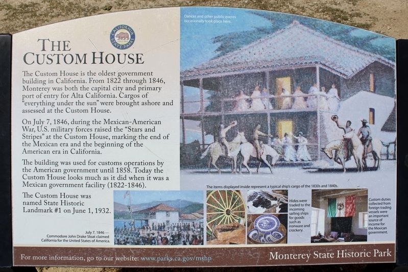
The Custom House
Photographed by Joseph Alvarado, April 26, 2022
1. The Custom House Marker
On July 7, 1846, during the Mexican-American War, U.S. military forces raised the “Stars and Stripes” at the Custom House, marking the end of the Mexican era and the beginning of the American era in California.
The building was used for customs operations by the American government until 1858. Today the Custom House looks much as it did when it was a Mexican government facility (1822-1846).
The Custom House was named State Historic Landmark #1 on June 1, 1932.
photo captions:
July 7, 1846 – Commodore John Drake Sloat claimed California for the United States of America (bottom left); The items displayed inside represent a typical cargo of the 1830s and 1840s (top, center); Hides were traded to the incoming sailing ships for goods such as ironware and crockery (bottom, center); Custom duties collected from foreign trading vessels were an important
this page online
Erected by Monterey State Historic Park. (Marker Number 1.)
Topics and series. This historical marker is listed in these topic lists: Government & Politics • Industry & Commerce • Landmarks • Settlements & Settlers. In addition, it is included in the California Historical Landmarks series list. A significant historical month for this entry is June 1781.
Location. 36° 36.197′ N, 121° 53.603′ W. Marker is in Monterey, California, in Monterey County. It can be reached from Monterey Peninsula Recreational Trail. The old Custom House is located just off the Monterey Peninsula Recreational Trail near the Old Fisherman's Wharf. Touch for map. Marker is in this post office area: Monterey CA 93940, United States of America. Touch for directions.

Regionally, this marker is on the Central Coast and specifically on the Coast Ranges. It is also on the American Pacific Coast. Globally, it is in North America, on the Ring of Fire, on the Pacific Rim, in the Western Hemisphere, in the Western World, and in the Anglosphere. Historically, it finds itself in what was
Photographed by Barry Swackhamer, January 29, 2013
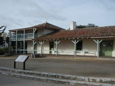
2. The Custom House and Marker
Other nearby markers. At least 8 other markers are within walking distance of this marker: A different marker also named Custom House (a few steps from this marker); Monterey Custom House (a few steps from this marker); Site of Original Flagstaff (within shouting distance of this marker); a different marker also named Custom House (within shouting distance of this marker); Monterey Customhouse (within shouting distance of this marker); Sloat's Landing (within shouting distance of this marker); Old Fisherman's Wharf (within shouting distance of this marker); Monterey Harbor (within shouting distance of this marker). Touch for a list and map of all markers in Monterey.
Another marker is no longer nearby. Custom House (was a few steps from this marker but has been replaced with another marker now near it).
Also see . . . Monterey's Custom House. At one time during California's Mexican era the Monterey Custom House presided over Mexico's only port of entry on the Alta California coast. It was here that Commodore John Drake Sloat raised the American flag on July 7, 1846, claiming over 600,000 square miles of territory for the United States. The Custom House is California's first registered State Historic Landmark, and is the oldest public building on the west coast.
Photographed by Barry Swackhamer, January 29, 2013
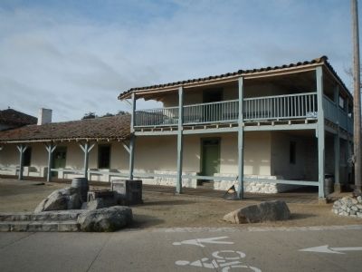
3. The Custom House
Photographed by Barry Swackhamer, January 29, 2013
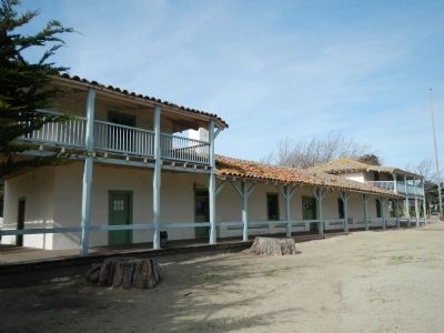
4. The Custom House
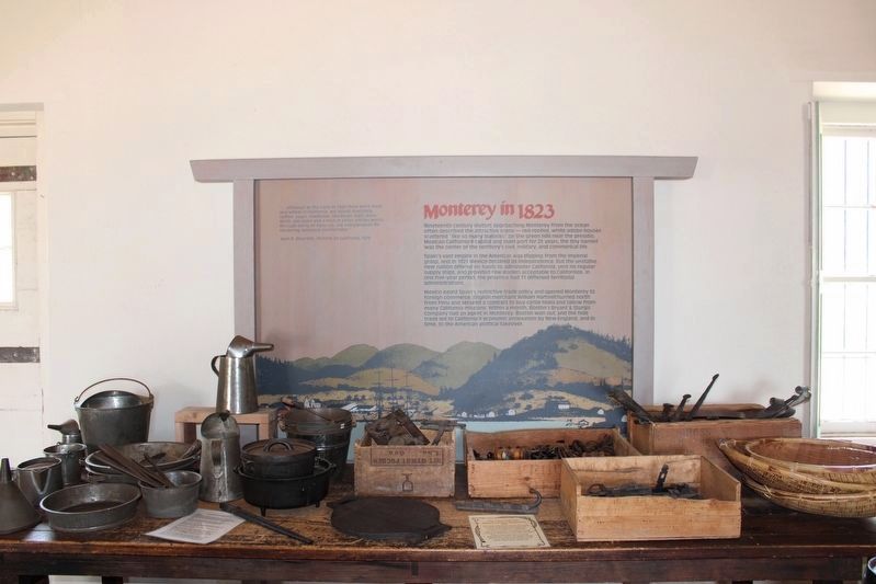
Photographed by Joseph Alvarado, April 26, 2022
5. Custom House Interior
Monterey in 1823
Nineteenth century visitors approaching Monterey from the ocean often described the attractive scene – red-roofed, white adobe houses scattered “like so many bullocks” on the green hills near the presidio. Mexican California’s capital and main port for 25 years, the tiny hamlet was the center of the territory’s civil, military, and commercial life.
Spain’s vast empire in the Americas was slipping from the imperial grasp, and in 1821 Mexico declared its independence. But the unstable new nation offered no funds to administer California, sent no regular supply ships, and provided few leaders acceptable to Californios. In one five-year period, the province had 11 different territorial administrators.
Mexico eased Spain’s restrictive trade policy and opened Monterey to foreign commerce. English merchant William Hartnell hurried north from Peru and secured a contract to buy cattle hides and tallow from many California missions. Within a month, Boston’s Bryant & Sturgis Company had an agent in Monterey. Boston won out, and the hide trade led to California’s economic annexation be New England, and in time, to the American political takeover.
Nineteenth century visitors approaching Monterey from the ocean often described the attractive scene – red-roofed, white adobe houses scattered “like so many bullocks” on the green hills near the presidio. Mexican California’s capital and main port for 25 years, the tiny hamlet was the center of the territory’s civil, military, and commercial life.
Spain’s vast empire in the Americas was slipping from the imperial grasp, and in 1821 Mexico declared its independence. But the unstable new nation offered no funds to administer California, sent no regular supply ships, and provided few leaders acceptable to Californios. In one five-year period, the province had 11 different territorial administrators.
Mexico eased Spain’s restrictive trade policy and opened Monterey to foreign commerce. English merchant William Hartnell hurried north from Peru and secured a contract to buy cattle hides and tallow from many California missions. Within a month, Boston’s Bryant & Sturgis Company had an agent in Monterey. Boston won out, and the hide trade led to California’s economic annexation be New England, and in time, to the American political takeover.
Credits. This page was last revised on July 1, 2022. It was originally submitted on February 6, 2013, by Barry Swackhamer of Brentwood, California. This page has been viewed 1,079 times since then and 63 times this year. Last updated on December 14, 2019, by Craig Baker of Sylmar, California. Photos: 1. submitted on May 22, 2022, by Joseph Alvarado of Livermore, California. 2, 3, 4. submitted on February 6, 2013, by Barry Swackhamer of Brentwood, California. 5. submitted on June 28, 2022, by Joseph Alvarado of Livermore, California.
