Dearborn in Wayne County, Michigan — The American Midwest (Great Lakes)
Harnessing Nature's Energy
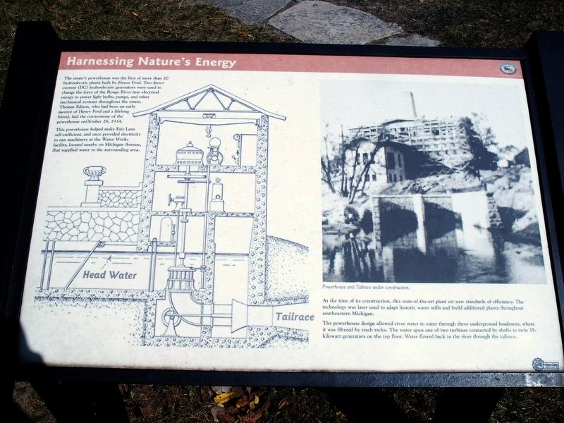
The estate's powerhouse was the first of more than 20 hydroelectric plants built by Henry Ford. Two direct current (DC) hydroelectric generators were used to change the force of the Rouge River into electrical energy to power light bulbs, pumps, and other mechanical systems throughout the estate. Thomas Edison, who had been an early mentor of Henry Ford and a lifelong friend, laid the cornerstone of the powerhouse on October 28, 1914.
This powerhouse helped make Fair Lane self-sufficient, and once provided electricity to run machinery at the Water Works facility, located nearby on Michigan Avenue, that supplied water to the surrounding area.
At the time of its construction, this state-of-the-art plant set new standards of efficiency. The technology was later used to adapt historic water mills and build additional plants throughout southeastern Michigan.
The powerhouse design allowed river water to enter through three underground headraces, where it was filtered by trash racks. The water spun one of two turbines connected by shafts to twin 55-kilowatt generators on the top floor. Water flowed back to the river through the tailrace.
Photo caption: Powerhouse and Tailrace under construction.
Erected by Henry Ford Estate and and MotorCities National Heritage Area.
Topics and series. This historical marker is listed in this topic list: Notable Buildings. In addition, it is included in the MotorCities National Heritage Area series list. A significant historical date for this entry is October 28, 1914.
Location. 42° 18.776′ N, 83° 13.914′ W. Marker is in Dearborn, Michigan, in Wayne County. Marker can be reached from Fair Lane Drive, 0.3 miles west of Evergreen Road. Marker is on the grounds of the Henry Ford Estate, Fair Lane, next to the Rouge River — behind the powerhouse building. Touch for map. Marker is at or near this postal address: 1 Fair Lane Drive, Dearborn MI 48128, United States of America. Touch for directions.
Other nearby markers. At least 8 other markers are within walking distance of this marker. Restoring Fair Lane Gardens (within shouting distance of this marker); Compost Then and Now (within shouting distance of this marker); In Honor of Friendship (within shouting distance of this marker); Preserving Fair Lane — An Iconic American Estate (within shouting distance of this marker); Restoring Fair Lane Infrastructure (within shouting distance of this marker); The Bur Oak and the Vegetable Garden (within shouting distance of this marker); Nature's Refrigeration (within shouting distance of this marker); Restoring Fair Lane Landscape (about 300 feet away, measured in a direct line). Touch for a list and map of all markers in Dearborn.
Also see . . .
Fair Lane, powerhouse. Architectural drawings of the Fair Lane Estate powerhouse and equipment. These drawings were made by Kent State University, School of Architecture and Environmental Design students and are part of the Historic American Buildings Survey. (Submitted on February 27, 2020, by Joel Seewald of Madison Heights, Michigan.)
Credits. This page was last revised on February 27, 2020. It was originally submitted on February 27, 2020, by Joel Seewald of Madison Heights, Michigan. This page has been viewed 122 times since then and 8 times this year. Photos: 1, 2, 3. submitted on February 27, 2020, by Joel Seewald of Madison Heights, Michigan.


