Park Slope in Brooklyn in Kings County, New York — The American Northeast (Mid-Atlantic)
The Old Stone House
Revolutionary War Heritage Trail
Photographed by Bill Coughlin, May 16, 2010
1. The Old Stone House Marker
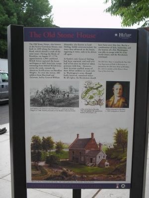
The Old Stone House, also known as the Vecte-Cortelyou House, was built in 1699 along the Gowanus Road, which skirted a creek of the same name. During the Battle of Brooklyn, on August 27, 1776, approximately 2,000 combined British forces captured the house and began to shell American troops retreating from behind British lines across the creek, towards the American fortifications on Brooklyn Heights. To cover the retreat, 400 soldiers from Maryland and Delaware, led by General William Alexander, also known as Lord Stirling, boldly counterattacked. Six times they advanced on the house, regaining it twice, only to be driven off again.
At battle’s end, General Stirling had been captured, and well over half of his men lay dead or taken prisoner with him. However, their heroism enabled many of their fellow soldiers to reach safety. Washington’s army, though badly battered, remained intact. By all rights, the Revolution should have been over that day. But by a combination of luck, leadership, and the bravery of a few, Washington was able to escape with his army nearly intact, and the Revolution continued.
The Old Stone House is owned by the New York City Department of Parks & Recreation, is operated by The Old Stone House of Brooklyn, Inc. and is a member of the Historic House Trust of New York City.
Erected by New
this page online
Topics. This historical marker is listed in this topic list: War, US Revolutionary. A significant historical year for this entry is 1699.
Location. Marker has been permanently removed. It was located near 40° 40.365′ N, 73° 59.008′ W. Marker was in Brooklyn, New York, in Kings County. It was in Park Slope. It was at the intersection of 5th Avenue and 3rd Street, on the right when traveling south on 5th Avenue. Touch for map. Marker was in this post office area: Brooklyn NY 11215, United States of America.
We have been informed that this marker is no longer there and will not be replaced. This page is an archival view of what was.
Regionally, this marker was in New York City and on Long Island. It was also in the American Northeast, in the Mid-Atlantic, and on the Eastern Seaboard. Globally, it was in the North Atlantic Region, North America, the Western Hemisphere, the Western World, and the Anglosphere. Historically, it found itself in what was once New Netherland and also one of the original Thirteen Colonies.

Other nearby markers. At least 8 other markers are within walking distance of this location: A different
Photographed by Bill Coughlin, May 16, 2010
2. Marker on 5th Avenue
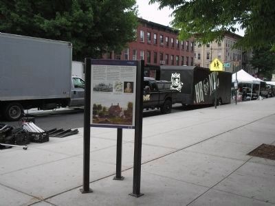
Another marker is no longer nearby. The Battle of Brooklyn (was here, next to this marker but has been permanently removed).
More about this marker. The bottom of the marker features a picture of the “Old Stone House at Gowanus by Louis Grube, 1846. Used by permission of the Brooklyn Historical Society.” Above this is a picture of “Lord Stirling at the Battle of Long Island, based on a painting by Alonso Chappel, ca. 1900. Used by permission of the Brooklyn Historical Society.” Next to this is a map of Brooklyn with the caption “A Plan of the Battle of Brooklyn. This map highlights the
Photographed by Bill Coughlin, May 16, 2010
3. Brooklyn Marker
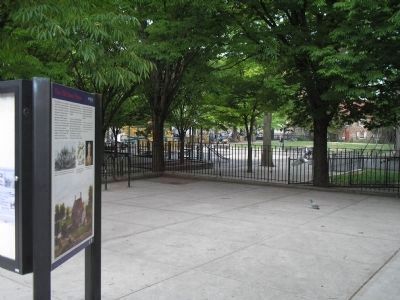
The Old Stone House can be seen in the park behind the marker.
Regarding The Old Stone House. The building is listed in the "AIA (American Institute of Architects) Guide to New York City, Fifth Edition".
Also see . . .
1. History of the Old Stone House. (Submitted on May 16, 2010, by Bill Coughlin of Woodland Park, New Jersey.)
2. The Battle of Long Island, August 27, 1776 at Long Island, New York. The American Revolutionary War website. (Submitted on May 16, 2010, by Bill Coughlin of Woodland Park, New Jersey.)
3. Battle of Long Island, August 27, 1776. (Submitted on May 16, 2010, by Bill Coughlin of Woodland Park, New Jersey.)
4. The Battle of Long Island 1776. A British perspective of the battle from BritishBattles.com. (Submitted on May 16, 2010, by Bill Coughlin of Woodland Park, New Jersey.)
5. Old Stone House of Brooklyn, The - National Archives. National Register of Historic Places documentation (Submitted on March 3, 2024, by Anton Schwarzmueller of Wilson, New York.)
Photographed by Bill Coughlin, May 16, 2010
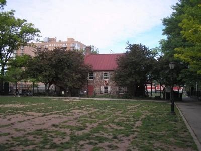
4. The Old Stone House
Some of the fiercest fighting of the Battle of Brooklyn occurred in the vicinity of this house.
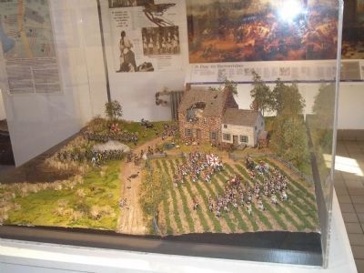
Photographed by Bill Coughlin, November 1, 2008
5. Old Stone House Model
This dioarama, displayed inside the Stone House, depicts the fighting during the August 27, 1776 battle.
Credits. This page was last revised on June 19, 2025. It was originally submitted on May 16, 2010, by Bill Coughlin of Woodland Park, New Jersey. This page has been viewed 1,884 times since then and 88 times this year. Last updated on March 5, 2020, by Larry Gertner of New York, New York. Photos: 1, 2, 3, 4, 5. submitted on May 16, 2010, by Bill Coughlin of Woodland Park, New Jersey. • Michael Herrick was the editor who published this page.
