Near Purcellville in Loudoun County, Virginia — The American South (Mid-Atlantic)
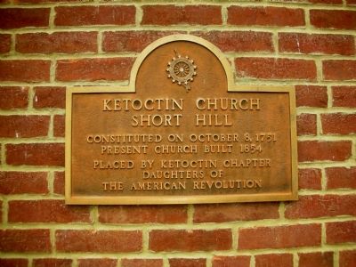
Ketoctin Church Short Hill
Present Church Built 1854
Placed By Ketoctin Chapter
Daughters Of
The American Revolution
Erected by Daughters of the American Revolution.
Topics and series. This historical marker is listed in these topic lists: Churches & Religion • Notable Buildings • Patriots & Patriotism • War, US Revolutionary. In addition, it is included in the Daughters of the American Revolution series list. A significant historical month for this entry is October 1861.
Location. 39° 9.448′ N, 77° 44.926′ W. Marker is near Purcellville, Virginia, in Loudoun County. Marker is at the intersection of Ketoctin Church Road (County Route 716) and Allder School Road (County Route 771), on the right when traveling south on Ketoctin Church Road. Touch for map. Marker is in this post office area: Purcellville VA 20134, United States of America. Touch for directions.
Other nearby markers. At least 8 other markers are within 3 miles of this marker, measured as the crow flies. Revolutionary War Patriots (within shouting distance of this marker); War of 1812 Veterans (within shouting distance of this marker); Adelaide Purcell (within shouting distance of this marker); Beyond Purcellville (approx. 2.2 miles away); Purcellville Station (approx. 2.2 miles away); A Little History (approx. 2.2 miles away); Welcome to Round Hill (approx. 2.2 miles away); Washington & Old Dominion Railroad Regional Park (approx. 2.2 miles away). Touch for a list and map of all markers in Purcellville.
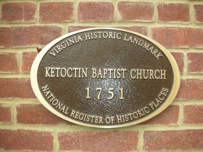
More about this marker. Historic Baptist church which was founded in 1751, located just east of Blue Ridge near Short Hill Mountain. This church was constituted during the French and Indian War. Seven church members, including Rev. John Marks, served in the Revolutionary War on the Patriot side. The marker is located on the front of the church building.
Related marker. Click here for another marker that is related to this marker. Buck Marsh Baptist Church near Berryville.
Also see . . . Ketoctin Church Cemetery. Listing from Find A Grave. (Submitted on December 24, 2008, by Craig Swain of Leesburg, Virginia.)

Photographed By Samuel Dalton, December 21, 2008
2. Ketoctin Baptist Church Marker
The church currently has a congregation that meets every Sunday. There is no indoor plumbing. The architectural appears unusual for a Baptist church and perhaps reflects a Quaker influence since the Quakers were very active in Loudoun County. It is quite possible the side door was for slaves; the church accepted blacks into membership.
Photographed By Samuel Dalton
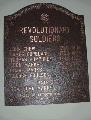
4. Revolutionary War Plaque
Mounted inside the church. It reads:
Revolutionary Soldiers
John Chew 1749-1836
James Copeland 1759-1838
Thomas Humphrey 1742-1822
Abel Marks 1760-1817
Isaiah Marks 1755-1785
George Poulson -1801
Patriot
Rev. John Marks 1716-1788
Placed by Ketoctin Chapter DAR June 5, 1977
Revolutionary Soldiers
John Chew 1749-1836
James Copeland 1759-1838
Thomas Humphrey 1742-1822
Abel Marks 1760-1817
Isaiah Marks 1755-1785
George Poulson -1801
Patriot
Rev. John Marks 1716-1788
Placed by Ketoctin Chapter DAR June 5, 1977
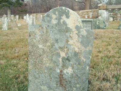
Photographed By Samuel Dalton
6. Gravestone of Rev. John Marks
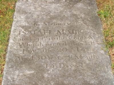
This is the gravestone of Rev. John Marks, Patriot soldier and Baptist preacher. The grave markings are barely legible. The grave was located by comparing a Marks family website photo taken in 2001. The photo was taken to the grave site, compared to the stones and it was determined that it was the correct stone by shape and location. The word "John M" is somewhat legible, but the headstone is in very poor condition. The DAR has an accompanying metal marker by Isaiah Marks' tombstone. Curiously, there is no marker for the Rev. John Marks, who was the pastor of this church by any organization, a situation which should be remedied.
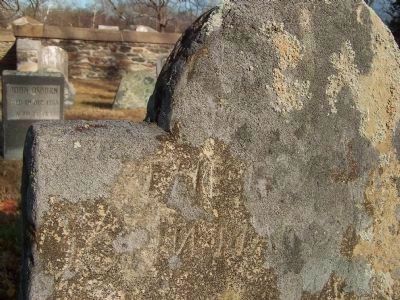
Photographed By Samuel Dalton
7. Rev. John Marks tombstone
Close up of Rev. John Marks tombstone. If you look very carefully you can make out 'JOHN' (the N is backwards) and the 'MA' of MARKS. John Marks was also instrumental in founding of the Buck Marsh Baptist Church near Berryville. (See related markers)
Credits. This page was last revised on December 26, 2023. It was originally submitted on December 22, 2008, by Samuel Dalton of Leesburg, Virginia. This page has been viewed 3,022 times since then and 82 times this year. Last updated on December 26, 2023, by Carl Gordon Moore Jr. of North East, Maryland. Photos: 1, 2, 3, 4, 5, 6. submitted on December 22, 2008, by Samuel Dalton of Leesburg, Virginia. 7. submitted on December 23, 2008, by Samuel Dalton of Leesburg, Virginia. • J. Makali Bruton was the editor who published this page.
