Golden in Jefferson County, Colorado — The American Mountains (Southwest)
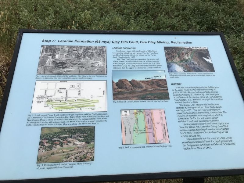
Stop 7: Laramie Formation (68 mya) Clay Pits Fault, Fire Clay Mining, Reclamation
Inscription.
Laramie Formation
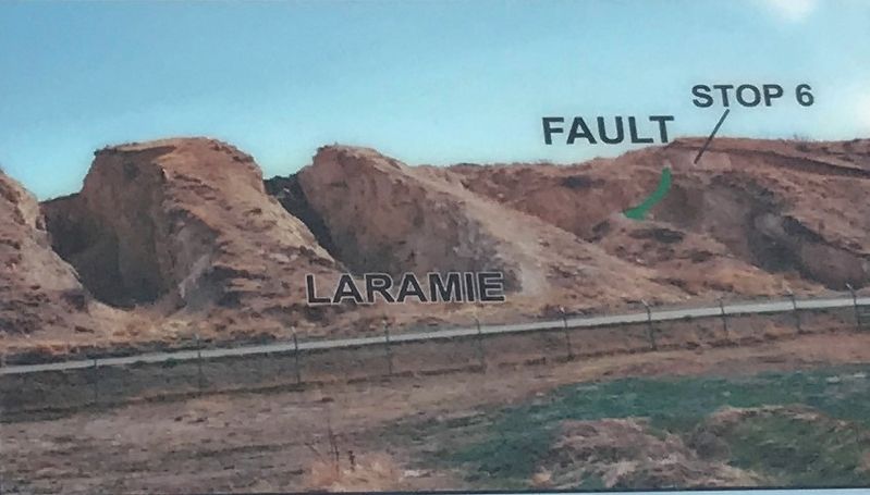
Sandstone ridges still stand south of 12th Street between the mined out clay areas (Fig. 4). The clays used for bricks and tiles were mined by the Parfet family beginning in 1877.
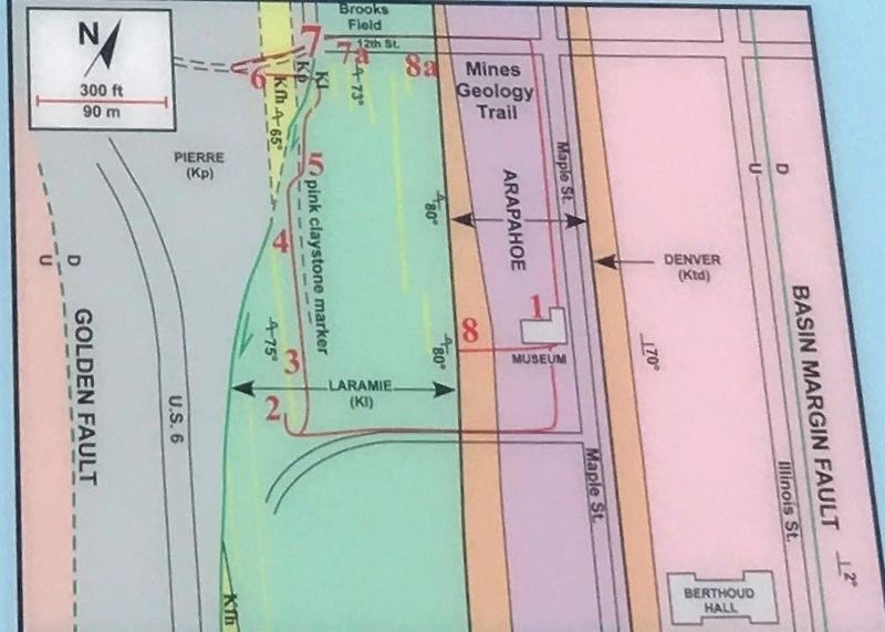
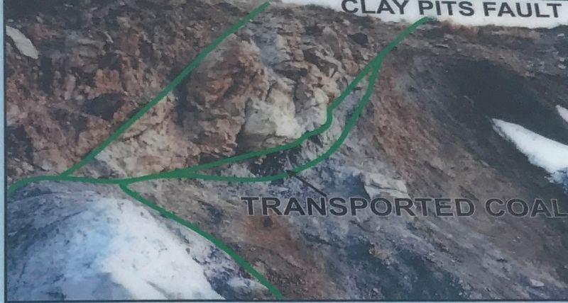
The Clay Pits Fault is exposed on the south wall where lower Laramie sandstones are in fault contact with a tongue of the Pierre Shale above the Fox Hills Sandstone (Fig. 5). Drag of strain under the fault plane indicates that the upper block moved to the southwest.
History
Clay and coal mining began in the Golden area in the early 1860s shortly after the discovery of gold in 1859 by George Jackson at Idaho Springs and John Gregory at Central City. The same year is credited with the starting of the city of Golden by Tom Golden. E.L. Berthoud surveyed the town lots in south Golden in 1860.
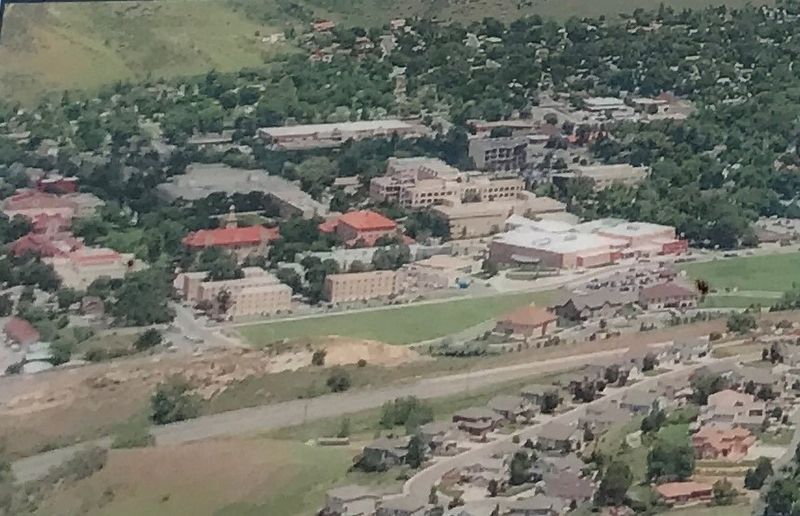
The Rubey Clay Mine at this locality was operated by four generations of the Parfet family starting in 1877. The clay was used largely to make bricks and tiles for building construction. The 36 acres of the mine were acquired by CSM in 1960s from the Parfets and is now largely reclaimed land used in campus expansion.
An important source of coal to the region was from the White Ash Coal mine dating from 1862 until accidental flooding closed the mine September 9, 1889 (location of the shaft on Fig. 2; see exhibit at Stop 7a).
These minerals and the water in Clear Creek provided an industrial base for rapid growth and the designation of Golden as Colorado's territorial capital from 1862 to 1867.
[Captions:]
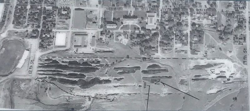
Top left: Fig. 1: Aerial photograph, 1948, of CSM and Rubey Clay Mine to the west. Dark areas are shadows in deep mine pits. Intervening light areas are sandstone ridges.
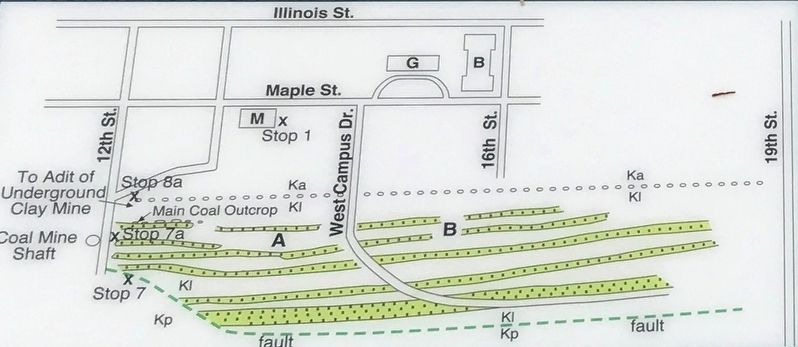
Middle left: Fig. 2: Sketch map of Figure 4 with sandstone ridges in yellow and Clay Pits Fault in green. Ka=Arapahoe; Kl=Laramine Formation; Kp=Pierre Shale. Area A between 12th Street and West Campus Drive is where the Rubey Mine was largely by surface methods; Area B was by underground mining with entrance near 12th Street. Rubey Mine is largely reclaimed by CSM. The shaft for the White Ash Coal Mine was along 12th Street near Stop 7a.
Bottom left: Fig. 3: Reclaimed north end of campus. Photo courtesy of Justin Sagarsee/Golden Transcript
Top middle: Fig. 4: Photo of Laramie, Pierre, and Fox Hills cut by Clay Pits Fault.
Bottom middle: Fig. 5: Bedrock geologic map with the Mines Geology Trail.
Top right: Fig. 6: Close-up of Clay Pit Fault with Laramie sandstone and transported coal (black zone) placed over an upper tongue of Pierre Shale.
Topics. This historical marker
Photographed By Duane and Tracy Marsteller, July 3, 2020
2. Stop 7: Laramie Formation (68 mya) Clay Pits Fault, Fire Clay Mining, Reclamation Marker Detail
Fig. 1: Aerial photograph, 1948, of CSM and Rubey Clay Mine to the west. Dark areas are shadows in deep mine pits. Intervening light areas are sandstone ridges.
Location. 39° 45.102′ N, 105° 13.658′ W. Marker is in Golden, Colorado, in Jefferson County. Marker is on 12th Street. Marker is located on a path near the western end of 12th Street. Touch for map. Marker is in this post office area: Golden CO 80401, United States of America. Touch for directions.
Other nearby markers. At least 8 other markers are within walking distance of this marker. White Ash Mine Disaster (within shouting distance of this marker); Stop 7a: White Ash Mine (within shouting distance of this marker); Billy Drew Bridge (approx. ¼ mile away); Rock Flour Millstone (approx. 0.3 miles away); Down by the Old Mill Stream (approx. 0.4 miles away); Colorado National Guard Armory (approx. 0.4 miles away); Castle Rock (approx. 0.4 miles away); The Astor House (approx. 0.4 miles away). Touch for a list and map of all markers in Golden.
Photographed By Duane and Tracy Marsteller, July 3, 2020
3. Stop 7: Laramie Formation (68 mya) Clay Pits Fault, Fire Clay Mining, Reclamation Marker Detail
Fig. 2: Sketch map of Figure 4 with sandstone ridges in yellow and Clay Pits Fault in green. Ka=Arapahoe; Kl=Laramine Formation; Kp=Pierre Shale. Area A between 12th Street and West Campus Drive is where the Rubey Mine was largely by surface methods; Area B was by underground mining with entrance near 12th Street. Rubey Mine is largely reclaimed by CSM. The shaft for the White Ash Coal Mine was along 12th Street near Stop 7a.
Credits. This page was last revised on August 9, 2020. It was originally submitted on July 14, 2020, by Duane and Tracy Marsteller of Murfreesboro, Tennessee. This page has been viewed 284 times since then and 23 times this year. Photos: 1, 2, 3, 4, 5, 6. submitted on July 14, 2020, by Duane and Tracy Marsteller of Murfreesboro, Tennessee. 7, 8. submitted on July 15, 2020, by Duane and Tracy Marsteller of Murfreesboro, Tennessee. • Andrew Ruppenstein was the editor who published this page.
