Santiago de Querétaro in Querétaro, Mexico — The Central Highlands (North America)
San Miguel Carrillo
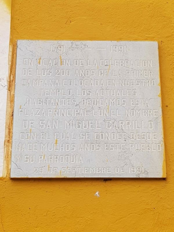
En ocacion de la celebración de los 200 años de la primer campaña colocada en nuestro templo. Los actuales habitantes dedicamos esta plaza principal con el nombre de San Miguel Carrillo con el cual se conoce desde hace muchos años este pueblo y su parroquia.
29 de septiembre de 1991.
1791 - 1991
On the occasion of the celebration of the 200th anniversary of the first bell to be placed in our temple. The current inhabitants dedicate this main square with the name of San Miguel Carrillo with which this town and its parish have been known for many years.
29 September 1991
Erected 1991 by Habitantes de San Miguel Carrillo.
Topics. This historical marker is listed in this topic list: Churches & Religion. A significant historical date for this entry is September 29, 1991.
Location. 20° 36.373′ N, 100° 25.738′ W. Marker is in Santiago de Querétaro, Querétaro. Marker is at the intersection of Guadalupe Victoria and San Miguel, on the right when traveling north on Guadalupe Victoria . Touch for map. Marker is in this post office area: Santiago de Querétaro QUE 76138, Mexico. Touch for directions.
Other nearby markers. At least 8 other markers are within 3 kilometers of this marker, measured as the crow flies. Delegación Felipe Carrillo Puerto (about 90 meters away, measured in a direct line); a different marker also named Delegación Felipe Carrillo Puerto (approx. 1.2 kilometers away); San Antonio de la Punta Catholic Church (approx. 1.2 kilometers away); Founders of the Association of the Heroic Military College (approx. 1.6 kilometers away); Chapel of Saint Gregory (approx. 2.3 kilometers away); The Chapel of La Piedad (approx. 2.5 kilometers away); Hill of the Bells (approx. 2.5 kilometers away); a different marker also named Hill of the Bells (approx. 2.5 kilometers away). Touch for a list and map of all markers in Santiago de Querétaro.
Credits. This page was last revised on August 15, 2020. It was originally submitted on August 15, 2020, by J. Makali Bruton of Accra, Ghana. This page has been viewed 87 times since then and 4 times this year. Photos: 1, 2, 3, 4. submitted on August 15, 2020, by J. Makali Bruton of Accra, Ghana.


