Gloucester in Gloucestershire, England, United Kingdom — Northwestern Europe (the British Isles)
St Oswald's Anglo Saxon Minster and Medieval Priory
Inscription.
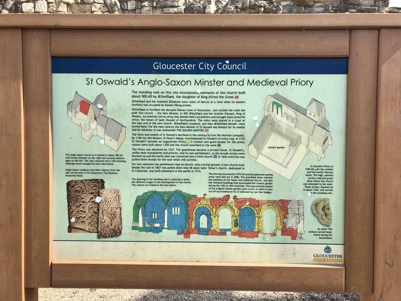
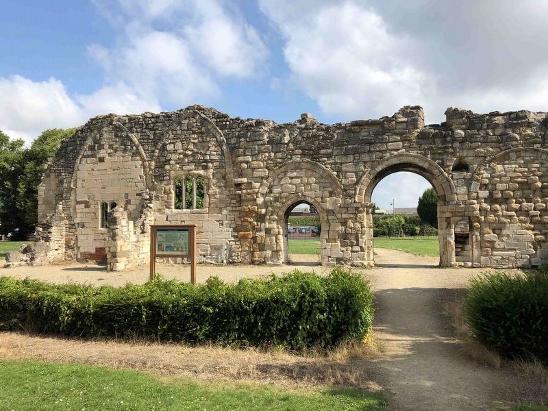
The standing wall on this site incorporates remnants of the church built about 900 AD by Aethelflaed, the daughter of King Alfred the Great.
Aethelflaed and her husband Aethelred were rulers of Mercia at a time when its eastern territory was occupied by Danish Viking armies.
Aethelflaed re-fortified the decayed Roman town of Gloucester. Just outside the walls she built this church — the New Minster. In 909 Aethelflaed and her brother Edward, King of Wessex, successfully led an army into Danish-held Lincolnshire and brought back powerful relics; the bones of Saint Oswald of Northumbria. The relics were placed in a crypt at the east end of the new church. Aethelflaed's husband, and then Aethelflaed herself, were buried here. For the next century the New Minster of St Oswald was famous for its wealth and its miracles; it was nicknamed The Golden Minster.
The fame and wealth of St Oswald's declined in the century before the Norman conquest. By 1100 the Old Minster, St Peter's Abbey, overshadowed St Oswald's in every way. In 1152 St Oswald's became an Augustinian Priory. A cloister and guest-houses for the priory canons were built about 1250 and the church extended to the west.
The Priory was dissolved by 1537. The guesthouse became a private house. St Oswald's, unlike most monasteries and priories, had its own parishioners, so the arcade arches were blocked up and the north aisle was converted into a little church. In 1656 even this was pulled down except for the wall which still survives.
For two centuries the parishioners had no church, only a burial ground. A new church built beside the ruin in 1867 was pulled down only 48 years later. Today's church, dedicated to St. Catharine, was built elsewhere in the parish in 1915.
Erected by Gloucester City Council.
Topics. This historical marker is listed in these topic lists: Architecture • Churches & Religion.
Location. 51° 52.169′ N, 2° 14.861′ W. Marker is in Gloucester, England, in Gloucestershire. Marker is on Archdeacon Street, on the left when traveling east. Touch for map. Marker is in this post office area: Gloucester, England GL1 2QS, United Kingdom. Touch for directions.
Other nearby markers. At least 1 other marker is within walking distance of this marker. Welcome to Llanthony Secunda Priory (approx. 1.1 kilometers away).
Photographed By Ray Gurganus, August 2, 2019
3. St Oswald's Anglo Saxon Minster and Medieval Priory Marker
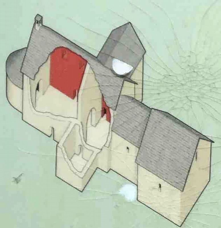
The Anglo Saxon church as it looked in about 920 AD with burial chamber on the right and unusual western apse on the Left. The wall coloured red is still standing, although much changed by later alterations.
Photographed By Ray Gurganus, August 2, 2019
6. St Oswald's Anglo Saxon Minster and Medieval Priory Marker
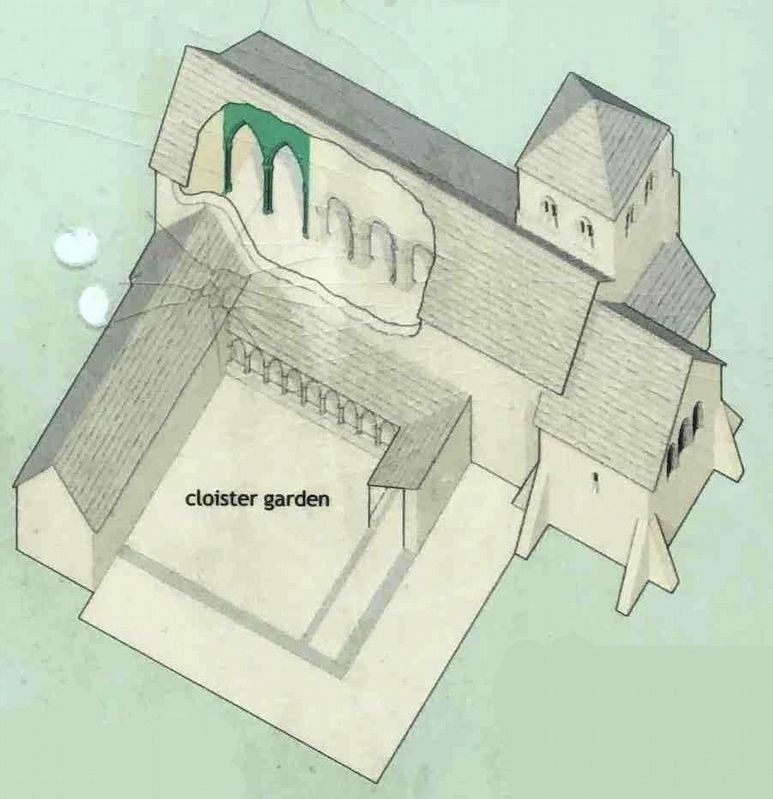
St Oswald's Priory in 1250 AD with the cloister and the earlier Norman tower. The high, pointed arches coloured green show where the church was extended to the west. These arches, blocked up in about 1550, still survive cn the standing ruin.
The site was excavated in 1975-83 and the paths and seating areas were laid out in 2006. The gravelled areas indicate the positions of the Saxon and medieval church, and also the monastic buildings that surrounded the cloister garden during the 13th to 16th centuries. The approximate extent of the original cloister garden (one corner of which is now cut off by Archdeacon St) is indicated by low Yew hedges.
The site was excavated in 1975-83 and the paths and seating areas were laid out in 2006. The gravelled areas indicate the positions of the Saxon and medieval church, and also the monastic buildings that surrounded the cloister garden during the 13th to 16th centuries. The approximate extent of the original cloister garden (one corner of which is now cut off by Archdeacon St) is indicated by low Yew hedges.
Credits. This page was last revised on January 27, 2022. It was originally submitted on August 19, 2020, by Ray Gurganus of Washington, District of Columbia. This page has been viewed 313 times since then and 33 times this year. Photos: 1, 2, 3, 4, 5, 6. submitted on August 19, 2020, by Ray Gurganus of Washington, District of Columbia. • Andrew Ruppenstein was the editor who published this page.
