Near Watrous in Mora County, New Mexico — The American Mountains (Southwest)
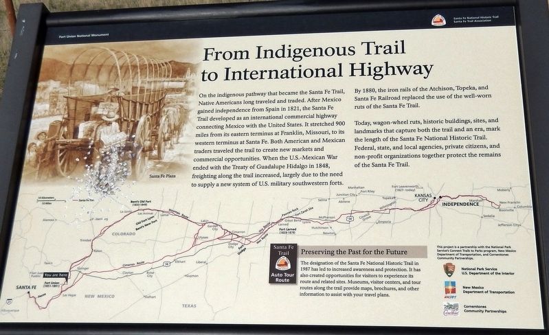
From Indigenous Trail to International Highway
Santa Fe National Historic Trail
— Fort Union National Monument —
Inscription.
On the indigenous pathway that became the Santa Fe Trail, Native Americans long traveled and traded. After Mexico gained independence from Spain in 1821, the Santa Fe trail developed as an international commercial highway connecting Mexico with the United States. It stretched 900 miles from its eastern terminus at Franklin, Missouri, to its western terminus at Santa Fe. Both American and Mexican traders traveled the trail to create new markets and commercial opportunities. When the U.S.-Mexican War ended with the Treaty of Guadalupe Hidalgo in 1848, freighting along the trail increased, largely due to the need to supply a new system of U.S. military southwestern forts.
By 1880, the iron rails of the Atchison, Topeka, and Santa Fe Railroad replaced the use of the well-worn ruts of the Santa Fe Trail.
Today, wagon-wheel ruts, historic buildings, sites, and landmarks that capture both the trail and an era, mark the length of the Santa Fe National Historic Trail. Federal, state, and local agencies, private citizens, and non-profit organizations together protect the remains of the Santa Fe Trail.
Preserving the Past for the Future
The designation of the Santa Fe National Historic Trail in 1987 has led to increased awareness and protection. It has also created opportunities for visitors to experience its route and related sites. Museums, visitor centers, and tour routes along the trail provide maps, brochures, and other information to assist with your travel plans.
This project is a partnership with the National Park Service's Connect Trails to Parks Program, New Mexico Department of Transportation, and Cornerstones Community Partnerships.
• National Park Service, U.S. Department of the Interior
• New Mexico Department of Transportation
• Cornerstones Community Partnerships
Erected by Santa Fe Trail Association.
Topics and series. This historical marker is listed in these topic lists: Forts and Castles • Industry & Commerce • Railroads & Streetcars • War, Mexican-American. In addition, it is included in the Santa Fe Trail series list.
Location. 35° 50.173′ N, 104° 59.888′ W. Marker is near Watrous, New Mexico, in Mora County. Marker is on New Mexico Route 161, 2.3 miles north of Interstate 25, on the right when traveling north. Marker is leftmost of three related interpretive panels at the Mountain Branch Trail Ruts Overlook on New Mexico Route 161. Touch for map. Marker is in this post office area: Watrous NM 87753, United States of America. Touch for directions.
Other nearby markers. At least 8 other markers are within 4 miles of this marker, measured as the crow flies. Intersection of History (here, next to this marker); A New Community Sprouts Roots
(here, next to this marker); A Show of Strength (approx. 0.6 miles away); Tides of Change (approx. 0.6 miles away); Lasting View (approx. 0.6 miles away); La Junta (approx. 2.6 miles away); Watrous - Western Junction of the Santa Fe Trail (approx. 3.2 miles away); Watrous (approx. 3.9 miles away). Touch for a list and map of all markers in Watrous.
Related markers. Click here for a list of markers that are related to this marker. Fort Union National Monument
Also see . . . Santa Fe Trail History. Before its demise due to the completion of the Santa Fe railroad, the Santa Fe Trail served as a thoroughfare for countless traders, pioneers and America’s military, and it played a crucial role in America’s westward expansion. (Submitted on September 28, 2020, by Cosmos Mariner of Cape Canaveral, Florida.)
Credits. This page was last revised on September 29, 2020. It was originally submitted on September 27, 2020, by Cosmos Mariner of Cape Canaveral, Florida. This page has been viewed 186 times since then and 31 times this year. Photos: 1, 2. submitted on September 28, 2020, by Cosmos Mariner of Cape Canaveral, Florida.

