Morehead in Rowan County, Kentucky — The American South (East South Central)
County Named, 1856
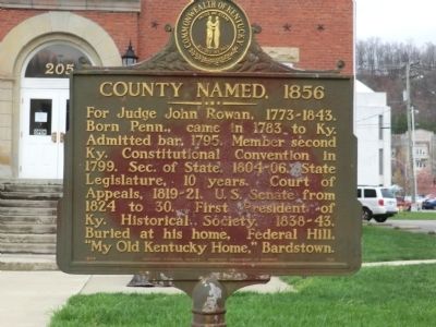
Photographed by Don Morfe, April 15, 2014
1. County Named, 1856 Marker
Erected 1964 by Kentucky Historical Society-Kentucky Department of Highways. (Marker Number 788.)
Topics and series. This historical marker is listed in these topic lists: Government & Politics • Political Subdivisions. In addition, it is included in the Kentucky Historical Society series list. A significant historical year for this entry is 1783.
Location. Marker has been reported permanently removed. It was located near 38° 11.064′ N, 83° 25.998′ W. Marker was in Morehead, Kentucky, in Rowan County. It was on East Main Street. The marker is on the grounds of the old Rowan County Courthouse. Touch for map. Marker was at or near this postal address: 261 E Main St, Morehead KY 40351, United States of America.
We have been informed that this marker is
this page online
Regionally, this marker was in Kentucky’s Outer Bluegrass and in the Cumberland Plateau. It was also in the American South, specifically in the Upper South, in Appalachia, and specifically in Southern Appalachia. Globally, it was in North America, the Western Hemisphere, the Western World, and the Anglosphere. Historically, it found itself in what was once the territory of the Mississippian Culture and also the Antebellum South.

Other nearby markers. At least 8 other markers are within walking distance of this location: Courthouse Burned (here, next to this marker); Quilting Memories (a few steps from this marker); Colonel John Hargis (a few steps from this marker); Freedom Park (within shouting distance of this marker); Spirit of the American Doughboy (within shouting distance of this marker); Allie Young Law Office (within shouting distance of this marker); Moonlight Schools (about 500 feet away, measured in a direct line); National Register Historic District / Morehead State University (about 700 feet away). Touch for a list and map
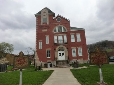
Photographed by Don Morfe, April 15, 2014
2. County Named, 1856 Marker
Credits. This page was last revised on January 10, 2021. It was originally submitted on May 17, 2014, by Don Morfe of Baltimore, Maryland. This page has been viewed 763 times since then and 18 times this year. Last updated on January 9, 2021, by Craig Doda of Napoleon, Ohio. Photos: 1, 2. submitted on May 17, 2014, by Don Morfe of Baltimore, Maryland. • Devry Becker Jones was the editor who published this page.
