How Big Is Fort Monroe?
Fort Monroe
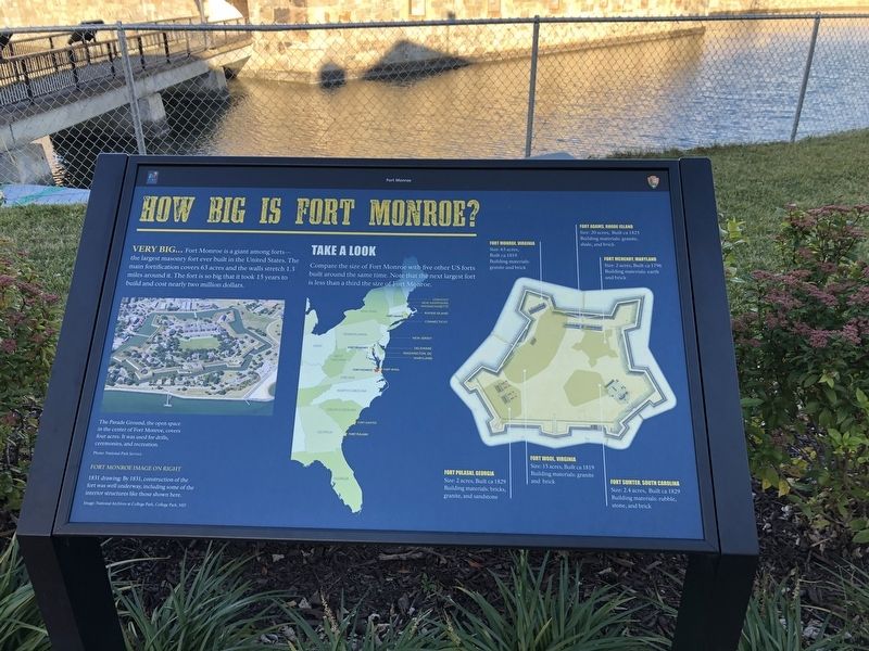
Very big… Fort Monroe is a giant among forts—the largest masonry fort ever built in the United States. The main fortification covers 63 acres and the walls stretch 1.3 miles around it. The fort is so big that it took 15 years to build the cost nearly two million dollars.
Take A Look
Compare the size of Fort Monroe with five other US forts built around the same time. Note that the next largest fort is less than a third the size of Fort Monroe.
Fort Monroe, Virginia
Size: 63 acres,
Built ca 1819
Building Materials: granite and brick
Fort Adams, Rhode Island
Size: 20 acres, Built ca 1825
Building materials: granite, shale, and brick
Fort McHenry, Maryland
Size: 2 acres, Built ca 1796
Building materials: earth and brick
Fort Pulaski, Georgia
Size: 2 acres, Built ca 1829
Building materials: bricks, granite, and sandstone
Fort Wool, Virginia
Size: 15 acres, Built ca 1819
Building materials: granite and brick
Fort Sumter, South Carolina
Size: 2.4 acres, Built ca 1829
Building materials: rubble, stone, and brick
[Caption:]
The Parade Ground, the open space in the center of Fort Monroe, covers four acres. It was used for drills, ceremonies, and recreation.
Erected by Fort
this page online
Topics. This historical marker is listed in this topic list: Forts and Castles. A significant historical year for this entry is 1819.
Location. 37° 0.134′ N, 76° 18.644′ W. Marker is in Hampton, Virginia. It is in Fort Monroe. It can be reached from Ingalls Road just north of Fenwick Road, on the right when traveling north. Touch for map. Marker is at or near this postal address: 30 Ingalls Rd, Fort Monroe VA 23651, United States of America. Touch for directions.

Regionally, this marker is on Virginia’s Peninsula and in Coastal Virginia. It is also in the American South, specifically in the Upper South, in the Tidewater, and on the Eastern Seaboard. Globally, it is in the North Atlantic Region, North America, the Western Hemisphere, the Western World, and the Anglosphere. Historically, it finds itself in what was once the territory of the Mississippian Culture, one of the original Thirteen Colonies, one of the Confederate States of America, and the Antebellum South.
Other nearby markers. At least 8 other markers are within walking distance of this
Credits. This page was last revised on February 1, 2023. It was originally submitted on February 9, 2021, by Devry Becker Jones of Washington, District of Columbia. This page has been viewed 524 times since then and 32 times this year. Photos: 1, 2. submitted on February 9, 2021, by Devry Becker Jones of Washington, District of Columbia.
