Story of Fort Amanda
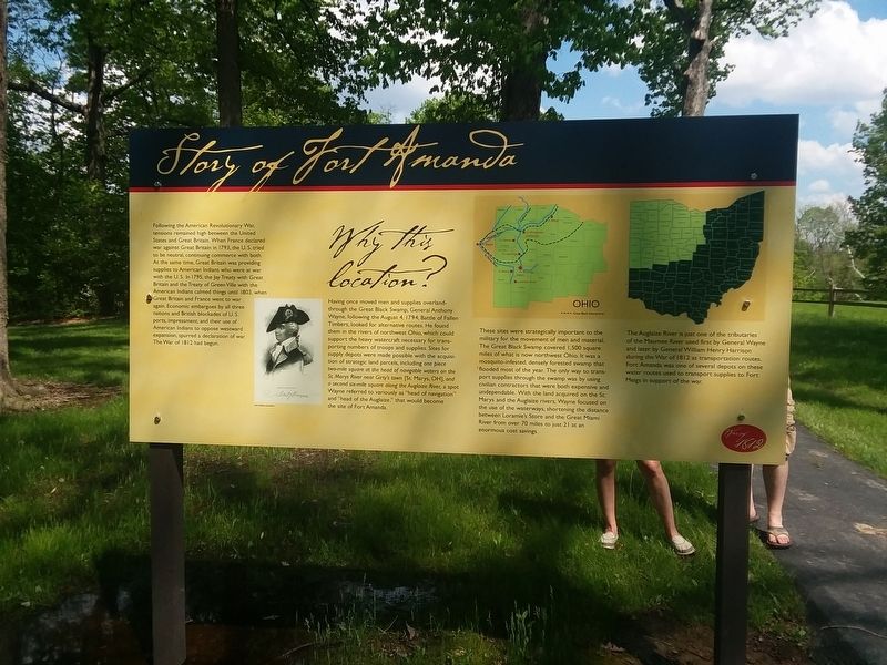
Following the American Revolutionary War, tensions remained high between the United States and Great Britain. When France declared war against Great Britain in 1793, the U. S. tried to be neutral, continuing commerce with both. At the same time, Great Britain was providing supplies to American Indians who were at war with the U.S. In 1795, the Jay Treaty with Great Britain and the Treaty of Green Ville with the American Indians calmed things until 1803, when Great Britain and France went to war again. Economic embargoes by all three nations and British blockades of U.S. ports, impressment, and their use of American Indians to oppose westward expansion, spurred a declaration of war The War of 1812 had begun.
Why this location?
Having once moved men and supplies overland-
through the Great Black Swamp, General Anthony
Wayne, following the August 4, 1794, Battle of Fallen
Timbers, looked for alternative routes. He found
them in the rivers of northwest Ohio, which could
support the heavy watercraft necessary for trans-
porting numbers of troops and supplies. Sites for
supply depots were made possible with the acquisi-
tion of strategic land parcels, including one piece
two-mile square at the head of navigable waters on the
St. Marys River near Girty's town [St. Marys, OH], and
a
second six-mile square along the Auglaize River, a spot
Wayne referred to variously as "head of navigation"
and "head of the Auglaize,” that would become
the site of Fort Amanda.
These sites were strategically important to the military for the movement of men and material. The Great Black Swamp covered 1,500 square miles of what is now northwest Ohio. It was a mosquito-infested, densely forested swamp that flooded most of the year. The only way to trans- port supplies through the swamp was by using civilian contractors that were both expensive and undependable. With the land acquired on the St. Marys and the Auglaize rivers, Wayne focused on the use of the waterways, shortening the distance between Loramie's Store and the Great Miami River from over 70 miles to just 21 at an enormous cost savings.
The Auglaize River is just one of the tributaries
of the Maumee River used first by General Wayne
and later by General William Henry Harrison
during the War of 1812 as transportation routes,
Fort Amanda was one of several depots on these
water routes used to transport supplies to Fort
Meigs in support of the war.
Erected by Ohio History Connection.
Topics. This historical marker is listed in these topic lists: Forts and Castles • War of 1812. A significant historical date for this entry is August 4, 1794.
Location.
Other nearby markers. At least 8 other markers are within walking distance of this marker. The Story of this Site (here, next to this marker); The Cemetery (within shouting distance of this marker); The 77 Unknown Soldiers (within shouting distance of this marker); Troops Stationed at Fort Amanda (about 400 feet away, measured in a direct line); a different marker also named Troops Stationed at Fort Amanda (about 400 feet away); a different marker also named Troops Stationed at Fort Amanda (about 400 feet away); Strategic Location (about 400 feet away); The Fort: Construction (about 700 feet away). Touch for a list and map of all markers in Kossuth.
Credits. This page was last revised on February 18, 2021. It was originally submitted on February 16, 2021, by Craig Doda of Napoleon, Ohio. This page has been viewed 281 times since then and 53 times this year. Photos: 1. submitted on February 16, 2021, by Craig Doda of Napoleon, Ohio. 2. submitted on February 17, 2021, by Craig Doda of Napoleon, Ohio. • Devry Becker Jones was the editor who published this page.
Editor’s want-list for this marker. A wide shot of the marker in context. • Can you help?

