Corinne in Box Elder County, Utah — The American Mountains (Southwest)
Evolution of Rail

Photographed By Connor Olson, April 16, 2021
1. Evolution of Rail Marker
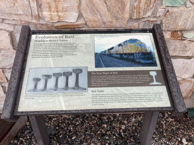
Photo Caption:A modern diesel locomotive rumming on "T" rail.
This photograph shows the evolution of rail from 1869 to 1969. Weight per yard is indicated at the bottom of each cross section of rail. As trains became heavier, rail became larger to accommodate the increased weight.
Helping to Build a Nation
Steel production increased rapidly in the United States after the Civil War. Prior to the war, the United States had not produced one single steel rail. By 1873, it had produced nearly 115,000 tons of steel rail. As steel prices continued to decrease, the old iron rails disappeared from the landscape and were replaced with shiny new steel ones. The transition from iron to steel decreased railroad costs, increased efficiency and facilitated the emergence of a new, stronger, more prosperous nation from the aftermath of the Civil War.
The New Shape of Rail
At first, steel rail mimicked the shape of the old iron pear rail. It was soon discovered, however, that steel's strength allowed for a more cost-effective design. Thus, the pear rail was replaced with “T” rail, which required less material to fabricate due to its sleeker form. In addition, the new steel rail did not need to be replaced nearly as often as the old iron rail. For both these reasons, steel rail allowed railroad companies to operate more efficiently.
Rail Today
The railroad industry has undergone many changes since the completion of the first transcontinental railroad. Mammoth diesel-powered locomotives roar down the tracks in place of their steam-driven ancestors, ghost towns dot the countryside where once thriving communities supported the early railroad and airplanes have become the dominant mode of long-distance passenger travel. Despite these and other changes, basic “T” shape rail has endured. Even today, you will find "T" rail on any modern railroad.
Erected by National Park Service, Department of the Interior.
Topics. This historical marker is listed in these topic lists: Industry & Commerce • Railroads & Streetcars. A significant historical year for this entry is 1873.
Location. 41° 37.049′ N, 112° 33.056′ W. Marker is in Corinne, Utah, in Box Elder County. Marker can be reached from North Golden Spike Drive West. The marker is located at the Golden Spike National Historic Park. Touch for map. Marker is at or near this postal address: 6200 North 22300 West, Corinne UT 84307, United States of America. Touch for directions.
Other nearby markers. At least 8 other markers are within walking distance of this marker. Transforming Communication: from Coast to Coast (here, next to this marker); Last Spike Driven (here, next to this marker); Original Rail (a few steps from this marker); Golden Spike (a few steps from this marker); Irish Monument (a few steps from this marker); The Southern Pacific Monument (a few steps from this marker); Competition 1869
(a few steps from this marker); Stephen Tyng Mather (within shouting distance of this marker). Touch for a list and map of all markers in Corinne.
Credits. This page was last revised on May 12, 2023. It was originally submitted on April 29, 2021, by Connor Olson of Kewaskum, Wisconsin. This page has been viewed 268 times since then and 25 times this year. Photos: 1. submitted on April 29, 2021, by Connor Olson of Kewaskum, Wisconsin. 2. submitted on May 12, 2023, by Jason Voigt of Glen Carbon, Illinois. 3. submitted on April 29, 2021, by Connor Olson of Kewaskum, Wisconsin. • Syd Whittle was the editor who published this page.

