Gilliam in Caddo Parish, Louisiana — The American South (West South Central)
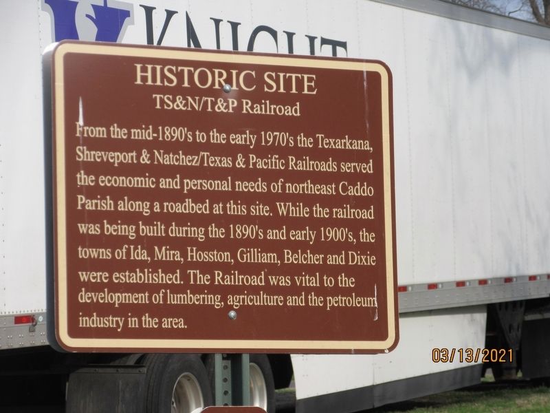
TS&N/T&P Railroad
Topics. This historical marker is listed in these topic lists: Railroads & Streetcars • Settlements & Settlers. A significant historical year for this entry is 1890.
Location. 32° 49.617′ N, 93° 50.727′ W. Marker is in Gilliam, Louisiana, in Caddo Parish. Marker is on 1st Street, 0.1 miles west of Main Street, on the right when traveling east. Touch for map. Marker is at or near this postal address: 5517 1st St, Gilliam LA 71029, United States of America. Touch for directions.
Other nearby markers. At least 8 other markers are within 3 miles of this marker, measured as the crow flies. Town of Gilliam (within shouting distance of this marker); Caddo Prairie Crossroads (within shouting distance of this marker); Gilliam Louisiana (within shouting distance of this marker); Gilliam United Methodist Church (about 600 feet away, measured in a direct line); Linda Lay Memorial (about 700 feet away); Reuben Thom Douglas Home (approx. 0.2 miles away); Justice Chapel Baptist Church (approx. 1.7 miles away); Lynn Plantation (approx. 2.4 miles away). Touch for a list and map of all markers in Gilliam.
Credits. This page was last revised on May 30, 2021. It was originally submitted on May 30, 2021, by Jason Armstrong of Talihina, Oklahoma. This page has been viewed 226 times since then and 27 times this year. Photo 1. submitted on May 30, 2021, by Jason Armstrong of Talihina, Oklahoma. • Mark Hilton was the editor who published this page.
Editor’s want-list for this marker. A wide shot of the marker and its surroundings. • Can you help?
