Near Fairbanks in Fairbanks North Star Borough, Alaska — Northwest (North America)
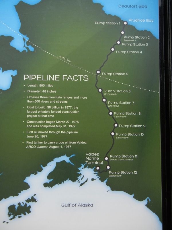
Pipeline Facts
• Length: 800 miles
• Diameter: 48 inches
• Crosses three mountain ranges and more than 500 rivers and streams
• Cost to build: $8 billion in 1977, the largest privately funded construction project at that time
• Construction began March 27, 1975 and was completed May 31, 1977
• First oil moved through the pipeline June 20, 1977
• First tanker to carry crude oil from Valdez: ARCO Juneau, August 1, 1977
Topics. This historical marker is listed in these topic lists: Industry & Commerce • Natural Resources. A significant historical date for this entry is June 20, 1977.
Location. 64° 55.75′ N, 147° 37.744′ W. Marker is near Fairbanks, Alaska, in Fairbanks North Star Borough. Marker is on Steese Highway (State Highway 2), on the right when traveling north. Marker is at Alaska Pipeline Viewing Point museum. Touch for map. Marker is at or near this postal address: 1671 Steese Highway, Fairbanks AK 99712, United States of America. Touch for directions.
Other nearby markers. At least 8 other markers are within 7 miles of this marker, measured as the crow flies. Pipeline History (within shouting distance of this marker); James A. Maple (within shouting distance of this marker); Gold Dredge No. 8 (approx. 0.9 miles away); Wickersham Cabin (approx. 6.4 miles away); Immaculate Conception Church (approx. 6.4 miles away); Lacey Street Theater (1939) (approx. 6˝ miles away); Barnette's Landing (approx. 6˝ miles away); Clay Street Cemetery (approx. 6˝ miles away). Touch for a list and map of all markers in Fairbanks.
Credits. This page was last revised on July 17, 2021. It was originally submitted on June 18, 2021, by Duane and Tracy Marsteller of Murfreesboro, Tennessee. This page has been viewed 189 times since then and 14 times this year. Photos: 1. submitted on June 18, 2021, by Duane and Tracy Marsteller of Murfreesboro, Tennessee. 2. submitted on July 17, 2021, by Duane and Tracy Marsteller of Murfreesboro, Tennessee.
Editor’s want-list for this marker. Wide shot of marker and surrounding area in context. • Can you help?

