The Way We Were…
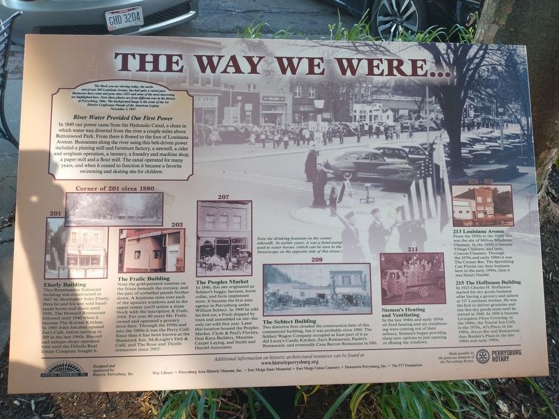
The block you are viewing today, the north- end of east 200 Louisiana Avenue, has had quite a varied past. Businesses have come andgone since 1823 and some of the most interesting are highlighted here. Note these photos are from different eras in the history of Perrysburg, Ohio. The background image is the scene of the 1st District Conference Parade of the American Legion, November 2, 1947.
River Water Provided Our First Power
In 1849 our power came from the Hydraulic Canal, a chute in
which water was diverted from the river a couple miles above
Buttonwood Park. From there it flowed to the foot of Louisiana
Avenue. Businesses along the river using this belt-driven power
included a planing mill and furniture factory, a sawmill, a cider
and sorghum operation, a tannery, a foundry and machine shop,
a paper mill and a flour mill. The canal operated for many
years, and when it ceased to function it became a favorite
swimming and skating site for children.
201
Eberly Building
This Renaissance Italianate
building was constructed in
1867 by shoemaker John Eberly.
Here he and his son sold handmade boots and shoes until
1926. The Howard Restaurant
followed until 1940 when it
became The Korner Kitchen.
In 1960 John Jakubec opened
Zee's Cafe, before moving to
209 in the
203
The Fralic Building
Note the gold-painted rosettes on
the frieze beneath the cornice, and
the pair of corbelled panels further
down. A keystone rests over each
of the upstairs windows and in the
upper center you'll notice a stone
block with the inscription R.Fralic,
1906. For over 40 years Mr. Fralic
owned and operated a grocery
store here. Through the 1930s and
into the 1960s it was the Perry Café.
Since then it has been known as the
Shamrock Inn, McKnight's Deli &
Café, and The Rose and Thistle
restaurant since 2002.
207
The Peoples Market
In 1846, this site originated as
Schlect's buggy, harness, horse
collar, and farm implement
store. It became the first auto
agency in Perrysburg under
William Schlect. In 1909 he sold
his first car, a Ford; shipped by
train and assembled on site-the
only car sold that year. Later
this location housed the Peoples
Market, Clyde & Paul's Florists,
Don Kern Builders, Maumee
Carpet Laying, and Smith and
Harold Associates.
Note the drinking fountain on the corner sidewalk. In earlier years, it was a hand pump used to water horses (which can be seen in the Streetscape on the opposite side of this street.)
209
The Schlect Building
Two distictive
211
Stemen's Heating
and Ventilating
In the late 1940s and early 1950s
oil fired heating and air conditioning were coming out of their
infancy. Stemen's began providng
these new options to just opening
or closing the windows.
213 Louisiana Avenue
From the 1920s to the 1940s this
was the site of Milton Mladenus
Cleaners. In the 1950s it became
Village Cleaners, and later,
Custom Cleaners. Through
the 1970s and early 1980s it was
The Corner Bar. The Sprinkling
Can Florist ran their business
here in the early 1990s, then it
was Smart Needle.
215
The Hoffmann Building
In 1923 Charles H. Hoffmann
started his dry goods business
after having a grocery and saloon
at 117 Louisiana Avenue. He was
the first to deliver groceries and
ran this dry goods store until he
retired in 1940. In 1956 it became
Livingston Floor Covering; in
the 1960s, the Tourist Inn Café;
in the 1970s, Al's Place; in the
1980s, Jerrys Bar and Restaurant;
then Bunker's Place in the late
1980s and early 1990s.
Topics. This historical marker is listed in this topic
Location. 41° 33.546′ N, 83° 37.763′ W. Marker is in Perrysburg, Ohio, in Wood County. Marker is on Louisiana Avenue (Ohio Route 199) just south of West 2nd Street, on the left when traveling north. Touch for map. Marker is at or near this postal address: 200 Louisiana Ave, Perrysburg OH 43551, United States of America. Touch for directions.
Other nearby markers. At least 8 other markers are within walking distance of this marker. History Happens Here… (within shouting distance of this marker); a different marker also named The Way We Were… (within shouting distance of this marker); a different marker also named History Happens Here… (about 300 feet away, measured in a direct line); a different marker also named History Happens Here… (about 300 feet away); a different marker also named The Way We Were… (about 300 feet away); a different marker also named The Way We Were… (about 300 feet away); a different marker also named History Happens Here… (about 400 feet away); Perrysburg / Perrysburg Plat Map (about 600 feet away). Touch for a list and map of all markers in Perrysburg.
Credits. This page was last revised on June 22, 2021. It was originally submitted on June 19, 2021, by Craig Doda of Napoleon, Ohio. This page has been viewed 256 times since then and 48 times this year. Photos: 1, 2, 3. submitted on June 19, 2021, by Craig Doda of Napoleon, Ohio. • Devry Becker Jones was the editor who published this page.


