Main Post in San Francisco City and County, California — The American West (Pacific Coastal)
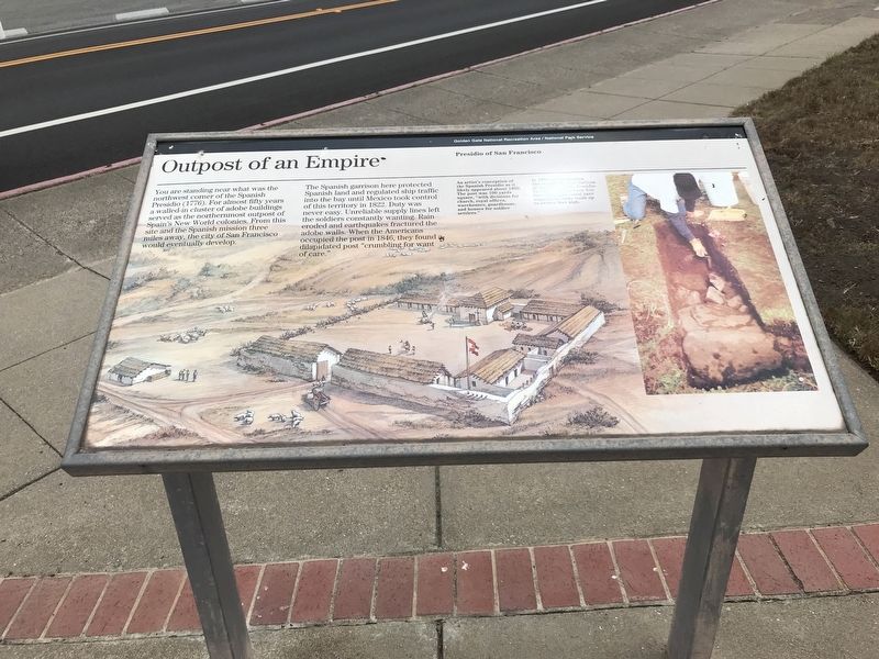
Outpost of an Empire
The Spanish garrison here protected Spanish land and regulated ship traffic into the bay until Mexico took control of this territory in 1822. Duty was never easy. Unreliable supply lines left the soldiers constantly wanting. Rain eroded and earthquakes fractured the adobe walls. When the Americans occupied the post in 1846, they found a dilapidated post "crumbling for want of care."
Captions
Larger image: An artist's conception of the Spanish Presidio as it likely appeared about 1800. The post was 100 yards square, "with divisions for church, royal offices, warehouses, guardhouse, and houses for soldier settlers."
Smaller image: In 1993, archaeologists discovered the foundations of the Spanish Presidio. The foundations were five feet wide and could have supported adobe walls up to twelve feet high.
Erected by National Park Service.
Topics. This historical marker is listed in this topic list: Forts and Castles. A significant historical year for this entry is 1776.
Location. 37° 47.913′ N, 122° 27.515′ W. Marker is in San Francisco, California, in San Francisco City and County. It is in Main Post. Marker is on Graham Street south of Sheridan Avenue, on the right when traveling south. Touch for map. Marker is in this post office area: San Francisco CA 94129, United States of America. Touch for directions.
Other nearby markers. At least 8 other markers are within walking distance of this marker. Pershing Square (here, next to this marker); North West Corner of Original Presidio (a few steps from this marker); Ammunition Magazine (within shouting distance of this marker); Old Post Chapel (about 400 feet away, measured in a direct line); War in the Philippines (about 500 feet away); The Ordoñez Gun (about 500 feet away); Sixth Army Headquarters (about 500 feet away); Montgomery Street Barracks (about 500 feet away). Touch for a list and map of all markers in San Francisco.
Credits. This page was last revised on February 7, 2023. It was originally submitted on July 6, 2021, by Duane and Tracy Marsteller of Murfreesboro, Tennessee. This page has been viewed 104 times since then and 13 times this year. Photos: 1, 2. submitted on July 6, 2021, by Duane and Tracy Marsteller of Murfreesboro, Tennessee.

