Near Columbus Grove in Putnam County, Ohio — The American Midwest (Great Lakes)
B-26B Bomber Crash
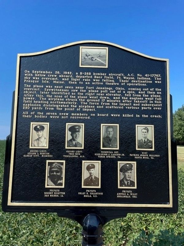
On September 26, 1942, a B-26B bomber aircraft, A.C. No. 41-17767, with crew below aboard, departed Baer Field, Ft. Wayne, Indiana. The sky was overcast, and light rain was falling. Their destination was Presque Isle, Maine, then to an active theatre of operations.
The plane was next seen near Fort Jennings, Ohio coming out of the overcast. Eyewitnesses saw the plane pull out of a spin, and then an object later identified as the right rear elevator, fell from the plane. After this, the nose of the plane went down, and the engines went full power. The airplane struck the ground 17 minutes after takeoff in this field heading northwesterly. The force from the impact and subsequent explosion disintegrated the airplane and scattered various parts over 250 yards from the point of impact.
All of the seven crew members on board were killed in the crash; their bodies were not recovered.
Second Lt. Eugene Nelson, Kansas City, Missouri • Second Lt. Fred Bice, Tuscaloosa, Alabama • Technical Sgt. Alexander Lamison Jr., Three Springs, Pennsylvania • Sgt. Patrick Nelligan, Santa Rosa, California • Private Robert Risetter, Des Moines, Iowa • Private Orley Colestock, Hecla, South Dakota • Private Arnold Wildt, Broadmead, Oregon
Erected 2021 by Fort Jennings Historical Society.
Topics. This historical marker is listed in these topic lists: Air & Space • Disasters • War, World II. A significant historical date for this entry is September 26, 1942.
Location. 40° 54.669′ N, 84° 13.499′ W. Marker is near Columbus Grove, Ohio, in Putnam County. Marker is on County Road 19, half a mile County Highway S, on the left when traveling north. Touch for map. Marker is at or near this postal address: 18560 Rd 19, Columbus Grove OH 45830, United States of America. Touch for directions.
Other nearby markers. At least 8 other markers are within 5 miles of this marker, measured as the crow flies. All Gave Some, Some Gave All (approx. 3.7 miles away); Fort Jennings (approx. 3.8 miles away); Fort Jennings 12 Unknown Soldiers (approx. 3.8 miles away); On September 26, 1942 (approx. 3.8 miles away); Fort Jennings Wall Of Honor (approx. 3.8 miles away); Combat Wounded Veterans (approx. 3.8 miles away); a different marker also named Fort Jennings (approx. 3.9 miles away); Col. Jennings Post 715 Veterans Memorial (approx. 4.1 miles away).
Regarding B-26B Bomber Crash. "The plane flew out of Fort Wayne, according to Amy Ricker, Fort Fest organizer and member of the Fort Jennings Historical Society. It was laden with beef, tomatoes and ammunition.."
Credits. This page was last revised on November 26, 2022. It was originally submitted on August 23, 2021, by Michael Baker of Lima, Ohio. This page has been viewed 1,305 times since then and 90 times this year. Photos: 1, 2, 3. submitted on August 23, 2021, by Michael Baker of Lima, Ohio. • Devry Becker Jones was the editor who published this page.


