Crescent City in Del Norte County, California — The American West (Pacific Coastal)
Tsunamis are Synonymous With Crescent City
Surge Depth Here: 7.75 Feet
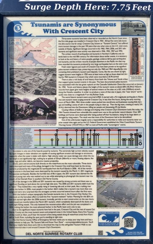
Thirty-seven tsunamis have been observed or recorded on the North Coast since the first tide gauge was installed in Crescent City in 1933. All but five were tele-tsunamis (the source was far away). Crescent City, known as "Tsunami Central,” has suffered more tsunami damage in the past 150 years than any other area on the U.S. west coast, outside of Alaska. Significant damage occurred in the 1960, 1964, 2006, and 2011 tele-tsunamis and significant wave activity was observed in 1946, 1952, 1957 and 1992.
The written record of earthquakes and tsunamis in Northern California only extends back to the mid-18th century. For information about earlier events, it is necessary to look at the oral history of native peoples, geologic evidence left by past earthquakes and tsunamis, and the written records of people elsewhere in the Pacific rim that may have recorded the tsunamis produced by very large earthquakes here on the west coast.
Fresh water lagoons just south of Crescent City have been proven to be excellent paleo-tsunami evidence traps, preserving not only the 1960 and 1964 deposits, but also containing thick prehistoric tsunami sand deposits. Cores, like the one shown at right, suggest tsunami wave heights in 1700 were at least twice as high as those observed during the 1964 tsunami in Crescent City which were recorded at 20.7ft (6.4m)!
There is also a rich body of oral history from both the Tolowa and Yurok tribes that support great tsunami events in the past. The best documented paleo-tsunami was associated with the last great rupture on the Cascadia Subduction Zone that occurred on January 26, 1700. Yurok oral history places the height of the tsunami waves at about 60ft (18.29m)! Historic records from Japan give wave heights of several meters at five sites on a 621 mile (1000km) stretch along the Honshu coastline. In order to produce a wave of that size in Japan, this "near shore” earthquake was close to a magnitude 9 on the Richter Scale.
The worst historic tsunami event occurred in 1964. It started with a 9.2 magnitude earthquake in Alaska that sent tsunami waves surging towards Crescent City. In less than five hours, during the early morning hours of March 28th, 1964, three smaller waves pushed into storefronts and businesses causing little damage and instilling a sense of calm in the people trying to clean up. Then the big wave, cresting at nearly 21ft (6.4m), slammed into the Downtown, killing ten people and devastating 29 city blocks.
Causing millions of dollars in damage and shaping what Crescent City's Downtown looks like today, the 1964 Tsunami showed how vulnerable this coastal town was to this particular natural disaster. Over 289 buildings and homes were destroyed after being pushed off their foundations, being hit by large debris or damaged by rising waters. The result was that most of the Downtown had to be demolished.
Out of this unfortunate tragedy came a responsibility for authorities to make sure tsunamis never surprise coastal cities again and so the U.S. Federal Government established the West Coast/Alaska Tsunami Warning Center (WCATWC) in 1967 to track all Pacific-wide "tsunamigenic” events.
Inundation is only one of the hazards posed by tsunamis. The extremely high current velocity caused by rapid changes in water elevation are capable of causing significant erosion and damage to structures, especially when the water is laden with debris. High velocity water can cause damage even when the water height is not significantly high, rushing by at speeds of 35mph (56km/h) or more, floating objects, like boats, logs and other debris, can become massive projectiles.
Docks, piers and structures built directly on the waterfront are the most vulnerable. Three docks were destroyed and many of the pilings damaged in the Crescent City small boat basin by the strong currents produced by the magnitude 8.3 earthquake from the Kuril Islands in 2006. All of the remaining structures in the boat basin were destroyed by the tsunami caused by the March 11, 2011 magnitude 9.2 Japanese earthquake. Besides the horrible loss of life in Japan, the 2011 tsunami also claimed the life of a local young man who was washed out to sea while attempting to photograph the tsunami near the mouth of the Klamath River in southern Del Norte County.
All of the damage in the 2006 and 2011 tsunamis was caused by strong currents and there was no significant flooding on land above the normal high tide zone. The 2006 and 2011 tsunamis didn't look like a "wave.” They looked like a very rapidly rising or lowering tide and, at their peak, like a rushing river within the harbor. In 2006, most people in the harbor didn't realize that a tsunami was more than one surge and were very surprised that the strongest currents occurred several hours after the first wave.
With the harbor's unique topography that funnels tsunamis into it, the Crescent City Harbor District took on the herculean effort to build the first "tsunami-resistant” harbor. Planning for this $54 million task started right after the 2006 tsunami. Ironically, permits to start construction on the new docks were issued just months before the March 2011 tsunami, which completely destroyed all the docks and sunk eight fishing vessels. This only hastened the reconstruction effort and the job was completed in 2014, making the harbor the most advanced harbor in the Pacific basin and a site to see.
Due to the significant impact tsunamis have had in the past, Crescent City and the rest of coastal Del Norte County are the most tsunami aware and prepared areas in the United States. Every first Tuesday of the month at 10am, you'll hear the tsunami sirens being tested along all waterfront areas from Klamath to Smith River, including the spot you're standing at right now.
The Del Norte County Office of Emergency Services wants you to enjoy your stay here and has a great website to help you "Be Tsunami Safe and Know Your Zone” - www.preparedelnorte.com. You'll find many helpful facts there and a link to download the map to this self-guided Tsunami Walk to see more historical sites in and around Crescent City's Downtown.
Erected by Del Norte County Office of Emergency Services, and Del Norte Sunrise Rotary Club.
Topics and series. This historical marker is listed in this topic list: Disasters. In addition, it is included in the Rotary International series list.
Location. 41° 45.173′ N, 124° 11.676′ W. Marker is in Crescent City, California, in Del Norte County. Marker is at the intersection of K Street and 2nd Street, on the right when traveling south on K Street. Touch for map. Marker is at or near this postal address: 200 K St, Crescent City CA 95531, United States of America. Touch for directions.
Other nearby markers. At least 8 other markers are within walking distance of this marker. Redwood National Park (within shouting distance of this marker); Crescent City Tsunami, 1964 (within shouting distance of this marker); Tsunami ! (about 500 feet away, measured in a direct line); Tetrapod (approx. 0.2 miles away); S.S. Emidio (approx. 0.2 miles away); Remembering Billy Boone (approx. ¼ mile away); Dedication to Henry Sause, Jr. (approx. 0.4 miles away); Battery Point Lighthouse (approx. ¾ mile away). Touch for a list and map of all markers in Crescent City.
Also see . . . PrepareDelNorte.Com. (Submitted on October 12, 2021.)
Credits. This page was last revised on October 12, 2021. It was originally submitted on October 12, 2021, by Craig Baker of Sylmar, California. This page has been viewed 684 times since then and 157 times this year. Photos: 1, 2. submitted on October 12, 2021, by Craig Baker of Sylmar, California.

