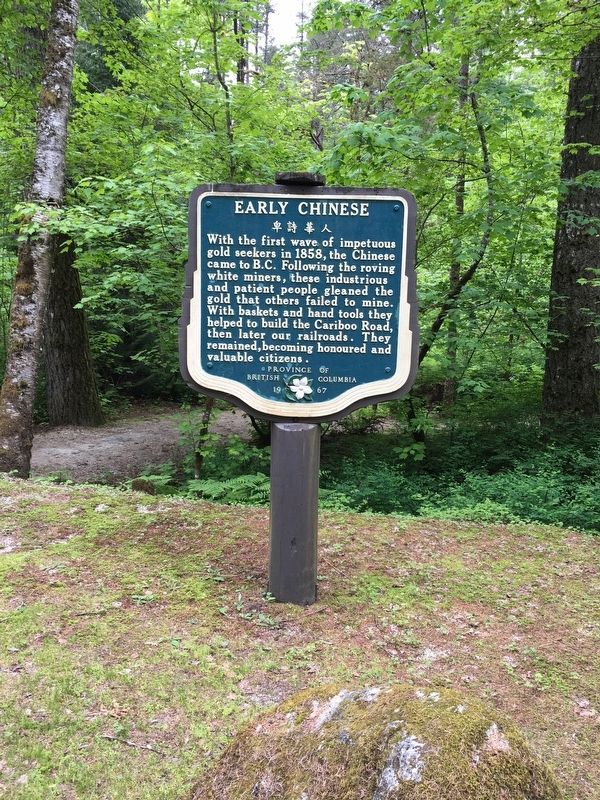
Near Squeah in Fraser Valley, British Columbia — Canada’s West Coast (North America)
Early Chinese

B.C. Ministry of Transportation and Infrastructure via Flickr (CC BY-NC-ND 2.0), April 29, 2016
1. Early Chinese Marker
Erected 1967 by Province of British Columbia.
Topics. This historical marker is listed in these topic lists: Industry & Commerce • Settlements & Settlers. A significant historical year for this entry is 1858.
Location. 49° 30.781′ N, 121° 24.908′ W. Marker is near Squeah, British Columbia, in Fraser Valley. Marker is on Emory Creek Park Road, 0.8 kilometers south of Trans-Canada Highway (Provincial Highway 1), on the left when traveling south. Marker is in the campground/picnic area of Emory Creek Provincial Park. Touch for map. Marker is in this post office area: Squeah BC V0X 1L3, Canada. Touch for directions.
Other nearby markers. At least 3 other markers are within 23 kilometers of this marker, measured as the crow flies. Historic Yale (approx. 5.7 kilometers away); The Yale Convention (approx. 5.7 kilometers away); J.W. Trutch (approx. 21.6 kilometers away).
Regarding Early Chinese. Excerpt from BC Parks' webpage for Emory Creek Provincial Park:
Emory Creek in 1858 was a tent and shack camp, established by miners in search of gold. When it became evident that the gold was not available in the amounts estimated, the miners started moving north on the Fraser River. A few Chinese remained in the area. The area came into the hands of a man named Walker, who felt Emory Creek would become the head of riverboat navigation on the Fraser. Eventually, he sold the land to the Oppenheimer Brothers in early 1879. In the fall of 1879, Emory was chosen by the C.P.R. as the western terminus. In a short time it became Emory Creek. The town consisted of thirteen streets with its own newspaper, various shops, a brewery, nine saloons and a sawmill. When Yale was made the terminus, Emory was all but abandoned by 1885, with the completion of the railway. Today, it is an easily accessible treed campground with paved roads and flush outhouses.
Also see . . . History of Chinese immigration to Canada. Wikipedia entry on the subject, including Chinese contributions to Canada's economy and war effort, Canada's 24-year near-ban on Chinese immigration and its apology nearly a century later. (Submitted on December 12, 2021, by Duane and Tracy Marsteller of Murfreesboro, Tennessee.)
Credits. This page was last revised on February 11, 2022. It was originally submitted on December 10, 2021, by Duane and Tracy Marsteller of Murfreesboro, Tennessee. This page has been viewed 81 times since then and 3 times this year. Photo 1. submitted on December 10, 2021, by Duane and Tracy Marsteller of Murfreesboro, Tennessee.
Editor’s want-list for this marker. A wide shot of the marker and its surroundings. • Can you help?