West Brattleboro in Windham County, Vermont — The American Northeast (New England)
West Brattleboro / Molly Stark Byway
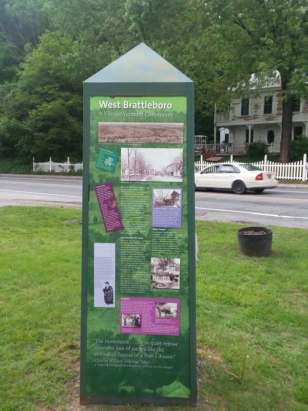
West Brattleboro
A Vibrant Vermont Community
The Molly Stark Byway winds through the heart of the village of West Brattleboro, past the small cluster of well-preserved 19th-century buildings around a small triangular green located about two miles west of downtown Brattleboro. Bonnyvale Brook, Whetstone Brook, and rounded Vermont hills create a striking natural setting. The village is now on the National Register of Historic Places, featuring a Historic District that consists of 10o acres and 17 buildings of Greek Revival and Italianate architecture.
Living Memorial Park, across the Creamery Bridge from the Molly Stark Byway, has reflected the community's interest in swimming, softball, skiing, and skating for over 50 years.
Lost Vermont Ski Areas
Bonnyvale Area was one of a number of tiny, short-lived "backyard” ski areas that provided generally free skiing (if you arrived early to pack down the snow) to local residents in the first, simple years after the sport was introduced to southern Vermont. These ski areas usually consisted of very narrow paths through woods that opened up into broad meadows at the base. A former enthusiast remembers the 1930s sedan parked in a shed at the top of the hill that provided power for the single rope tow.
Fred Harris, born in Brattleboro in 1887, was one of the pioneers of winter sports in this country. He introduced ski jumping to Brattleboro and directed the construction of Harris Hill, the ski jump that bears his name. He inaugurated a series of increasingly successful ski meets in Brattleboro that laid the foundation for the modern winter sports industry in this area.
Water Power
Three streams run through West Brattleboro. In the early days, river rock: proved valuable to farmers to whet (grind) their tools, so one brook became known as Whetstone Brook. Another stream cuts a beautiful valley in a high area between West Brattleboro and Guilford, thus the name "Bonnyvale Brook.” Ames Hill Brook is a tributary of the Whetstone and was the site of several mills.
Farmer's Market West Brattleboro's famous Farmer's Market, one of the oldest in the region, features handmade and homegrown products from May through October.
Turkey Days Huge flocks of turkeys used to be walked from New York State to Brattleboro, recounted the late George Briggs of Searsburg, Vermont, who served as Town Clerk for 50 years. When the drovers were overtaken by darkness, thousands of turkeys roosted in the trees and on the rooftops of wayside farms, he remembered. In the morning, the turkeys were lured down from the roofs and trees with corn strewn on the ground. Soon the road was alive with gobbling turkeys strutting slowly to their distant market in Brattleboro.
Did You Know? ...that in West Brattleboro there once stood a preeminent school, first known as Brattleboro Academy (co-ed, est. 1801) and then eventually as Glenwood Ladies Seminary? For a few years, the school was also open to summer boarders. One newspaper account describes the success of a gymnastics class led on Seminary grounds by a Professor Welch from Yale: “I have no doubt you would be as astonished, as the admirers of muscle are cheered, at the way they march and stamp and beat their chests and gesticulate and attitudinize. Occasionally the guests recreate themselves with parlor theatricals. At one of these .. a pistol charge of powder was lodged in the eye of one of the actors.... It is to be presumed that this was a part of the program."
Creamery Bridge: A Vermont Icon
Brattleboro was once known for its variety of covered bridges, but the Creamery Bridge is the only surviving covered wooden bridge in the town. Built in 1879 of spruce lumber in a Town Lattice design, the bridge is one of Vermont's best-preserved bridges and spans the powerful Whetstone Brook. A dairy creamery was once located nearby. The sidewalk and slate roof was added in 1917.
Collection of Brattleboro Historical Society.
Imagine...
It is 1907. You have brushed Dolly the mare to a dappled gleam and picked the peonies from the garden to decorate the wagon. This July morning, you and your best friend Lily laid out a "summer white” outfit, including grandly plumed hats. Dolly gets to wear plumage and flowers too. You all proudly pose for the photographer on the West Brattleboro Town Green, unaware that a century later your image will be on public view in an unimaginably changed world.
Vermonters used any excuse for a parade or a fair, whether it be Old Home Day, the circus coming to town, political or athletic events, or a military commemoration-any reason was motivation enough to dress up in finery, drape patriotic bunting from buildings, and march or ride exuberantly through villages and towns to show off flashy horses or new automobiles . or yourself.
“The mountains . . . lie in quiet repose upon the face of nature like the embodied fancies of a Poet's dream."
— Charles William Eldridge (1833) a “dashing young miniature painter with an eye for beauty"
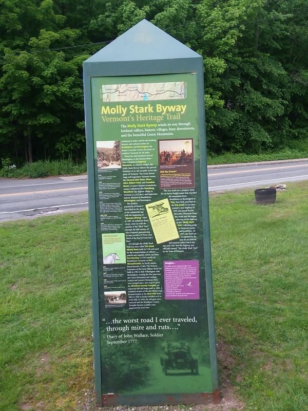
Molly Stark Byway
Vermont's Heritage Trail
The Molly Stark Byway winds its way through lowland valleys, historic villages, busy downtown's and the beautiful Green Mountains.
Anchored at either end by the bustling historic and cultural centers of Brattleboro and Bennington, the Route 9 corridor crosses the heart of southern Vermont for
From the rich farmland west of Bennington, to the famous three- state-overlook at Hogback Mountain, to covered bridges, the Molly Stark Byway follows the general footsteps of an old turnpike across the spine of Vermont. The scenic byway rings with legendary Vermont names like General John Stark, Ethan Allen, Robert Frost, and Grandma Moses. It passes famous monuments, unique settlements like Searsburg, Woodford (the highest village in Vermont at 2,215 feet), and important historic districts in Brattleboro, Wilmington, and Bennington.
The modern popularity of Route 9 dates back to the dawn of the automobile age with the beginning of "pleasure driving” when in 1907 an ambitious hotel owner came up with the concept of the "Ideal Tour" through the hill country of New England, guaranteeing to auto travelers “A First Class Hotel at the End of Each Day's Run."
It is thought the Molly Stark Trail was once called The Great Albany Road, built in 1746 and used for the transportation of military patrols and supplies, which ran from Fort Dummer (1724) outside of Brattleboro, Vermont, to Fort Massachusetts, in North Adams, Massachusetts (1746). The Western Extension of the Great Albany Road was built in 1762 to link Wilmington with Bennington, creating the first pass over the Green Mountains and uniting y eastern and western Vermont, Parts were merged into a new road to form the Windham County Turnpike, an improved toll and stage road, in 1802, A southern section of the old Albany road became known as the Shun Pike from 1802 to 1836 as locals traveled on it to avoid tolls. In 1836, the toll gates were removed and the Windham County Turnpike became a public road, supported by local taxes.
The new road was a primary route for six-horse freight teams that traveled the mountains from Brattleboro to Bennington to Troy, New York, and then to the Erie Canal. It was later named a state highway in 1931 and paved shortly thereafter. Postcards from the 1920s and 1930s began referring to the highway as the “Molly Stark Trail,” reflecting pride in Vermonter’s roots and traditions. In 1937 the Trail was recognized by the state for its historic and tourism values, but it was not until 1967 that the highway was officially named “The Molly Stark Trail” by the State of Vermont.
1724 Fort Dummer built, first white settlement in Vermont
1746 Great Albany Road laid between Fort Dummer and Wilmington, Vermont, then south to Fort Massachusetts in North Adams, Massachusetts
1762 Western Extension of Great Albany Road constructed from Wilmington to Bennington, linking western and eastern Vermont
1777 In August, General John Stark rouses his farmer soldier troops to defeat the British at the Battle of Bennington with his call for victory, "There are the Red Coats and the enemy are ours or this night Molly Stark sleeps a widow."
1802-1836 Windham Turnpike Company operates turnpike as a toll and stage road
1907 Part of the "Ideal Tour,” developed by an entrepreneurial hotel owner to encourage pleasure driving at the dawn of the automobile age
1931 Accepted as a state highway and paved shortly thereafter
1937 Recognized by the State of Vermont for its historic and tourism values
1967 Officially named "Molly Stark Trail” by State of Vermont
2003 Designated a Vermont Scenic Byway
Did You Know?
...that five (highly unpopular) toll gates from Brattleboro to Bennington collected tolls for nearly 40 years? Fees charged by independent toll operators included $1 for 4-horse stagecoaches, 50 cents to 63 cents for 4-wheeled vehicles, and a penny each for sheep and swine.
Did You Know?
...that military roads were generally built in a hurry through rough terrain? By today's standards, the "Great Road” was little more than a widened path following Native American traces through the mountains of southern Vermont. Trees in the roadway were often not uprooted; their trunks were cut 12” to 18” off the ground, adequate height for military wagons, cannons, and carts to pass over them.
Did You Know?
.. that one of the turning points of the American Revolutionary war was the Battle of Bennington? It was on August 16, 1777 that a group of farmer soldiers carrying their weapons from home were mustered by General John Stark of New Hampshire. These patriots and their leader won a major victory over the British, marching in battle lines to the fields near Bennington.
Imagine...
It is 1804. You are resting overnight at the Walloomsac Inn in Old Bennington. To travel on to Brattleboro, you face an arduous two-day journey in a coach pulled by four horses who will slog up the Green Mountains on the raw, steep road full of potholes, stumps, and ruts. Swarms of mosquitos and stifling summer heat will torment you in the small confines of the coach cabin where you will be crammed next to strange fellow travelers. Your coach may become hopelessly mired in mud. A forbidding wilderness surrounds you, except for small settlements of human habitation along the route.
"...the worst road I ever traveled, through mire and ruts...
— Diary of John Wallace, Soldier September 1777 (Marker Number 2.)
Topics. This historical marker is listed in this topic list: Exploration. A significant historical month for this entry is September 1777.
Location. 42° 51.006′ N, 72° 35.164′ W. Marker is in Brattleboro, Vermont, in Windham County. It is in West Brattleboro. Marker is on Western Avenue (Vermont Route 9) west of Guilford Street, on the right when traveling east. Touch for map. Marker is at or near this postal address: 548 Western Ave, Brattleboro VT 05301, United States of America. Touch for directions.
Other nearby markers. At least 8 other markers are within 2 miles of this marker, measured as the crow flies. Creamery Bridge Native Plant Restoration Project (within shouting distance of this marker); a different marker also named Creamery Bridge Native Plant Restoration Project (within shouting distance of this marker); Glenwood Seminary and Brattleborough Academy (approx. 0.7 miles away); Mary Wilkins Freeman (approx. 0.7 miles away); Brattleboro / Molly Stark Byway (approx. one mile away); Estey Organ Company (approx. 1.2 miles away); The First Building of the Centre Congregational Church (approx. 1.4 miles away); Memorial Tree (approx. 1.4 miles away). Touch for a list and map of all markers in Brattleboro.
Also see . . . Molly Stark Byway (Vermont Tourism Website). (Submitted on April 1, 2022, by Michael Herrick of Southbury, Connecticut.)
Credits. This page was last revised on August 11, 2023. It was originally submitted on March 25, 2022, by Craig Doda of Napoleon, Ohio. This page has been viewed 183 times since then and 13 times this year. Photos: 1, 2, 3. submitted on March 25, 2022, by Craig Doda of Napoleon, Ohio. 4. submitted on August 11, 2023, by Devry Becker Jones of Washington, District of Columbia. • Michael Herrick was the editor who published this page.


