Ironville in Essex County, New York — The American Northeast (Mid-Atlantic)
On The Train
Station 5
Photographed by Steve Stoessel, April 10, 2022
1. On The Train Marker
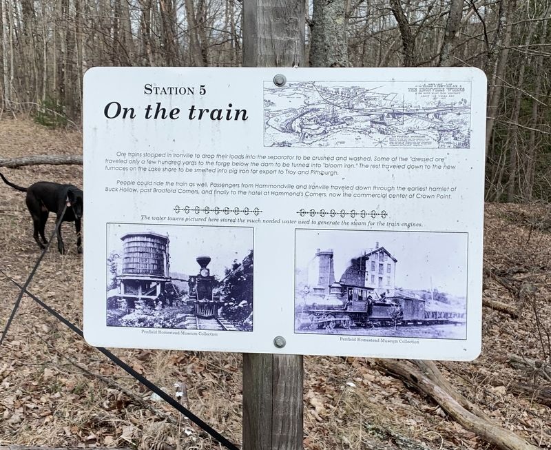
Ore trains stopped in Ironville to drop their loads into the separator to be crushed and washed. Some of the "dressed ore" traveled only a few hundred yards to the forge below the dam to be turned into "bloom iron.” The rest traveled down to the new furnaces on the Lake shore to be smelted into pig iron for export to Troy and Pittsburgh.
People could ride the train as well. Passengers from Hammondville and Ironville traveled down through the earliest hamlet of Buck Hollow, past Bradford Corners, and finally to the hotel at Hammond's Corners, now the commercial center of Crown Point.
The water towers pictured here stored the much needed water used to generate the steam for the train engines.
(Marker Number 5.)
Topics. This historical marker is listed in this topic list: Industry & Commerce.
Location. 43° 55.337′ N, 73° 32.045′ W. Marker is in Ironville, New York, in Essex County. It can be reached from the intersection of Creek Road (County Route 2) and Peasley Road, on the left when traveling west. Touch for map. Marker is in this post office area: Crown Point
this page online

Regionally, this marker is in Upstate New York, in the Adirondacks & North Country, and in the Champlain Valley. It is also in the American Northeast and in the Mid-Atlantic. Globally, it is in North America, the Great North Woods, the Western Hemisphere, the Western World, and the Anglosphere. Historically, it finds itself in what was once the Viceroyalty of New France, New Netherland, and one of the original Thirteen Colonies.
Other nearby markers. At least 8 other markers are within walking distance of this marker: Mills (a few steps from this marker); Scale House (within shouting distance of this marker); Dressed Ore (within shouting distance of this marker); 1873 Expansion (about 300 feet away, measured in a direct line); Charcoal (about 400 feet away); The Forge (about 400 feet away); Penfield Homestead Museum (about 500 feet away); Penfield Pond (about 500 feet away). Touch for a list and map of all markers in Ironville.
Another marker is no longer nearby. Birthplace of the Electrical Age (was about 500 feet away but has been permanently removed).
Photographed by Steve Stoessel, April 10, 2022
2. On The Train Marker
Also see . . . Ironville Historic District - National Archives. National Register of Historic Places documentation (Submitted on February 6, 2024, by Anton Schwarzmueller of Wilson, New York.)
Credits. This page was last revised on February 6, 2024. It was originally submitted on April 20, 2022, by Steve Stoessel of Niskayuna, New York. This page has been viewed 169 times since then and 11 times this year. Photos: 1, 2. submitted on April 20, 2022, by Steve Stoessel of Niskayuna, New York. • Michael Herrick was the editor who published this page.
