Mackinaw City in Emmet County, Michigan — The American Midwest (Great Lakes)
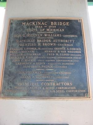
Mackinac Bridge
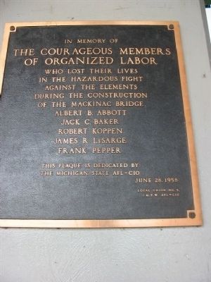
Courageous Members of Organized Labor
Inscription.
State of Michigan
Hon. G. Mennen Williams · Governor
Mackinac Bridge Authority
Prentiss M. Brown · Chairman
Charles T. Fisher, Jr. · Deceased; George A. Osborn
Mead L. Bricker; Murray D. Van Wagoner
William J. Cochran; Fred M. Zeder · Deceased
Charles M. Ziegler · St Highway Commissioner · 1950-57
John C. Mackie · State Highway Commissioner · 1957-
Lawrence A. Rubin · Executive Secretary
Sanford A. Brown · Treasurer
D. B. Steinman · Consulting Engineer
Glenn B. Woodruff · Consultant
Principal Contractors
Merritt-Chapman & Scott Corporation
American Bridge Division of U.S. Steel Corporation
Nearby marker
In memory of The Courageous Members of Organized Labor who lost their lives in the hazardous fight against the elements during the construction of the Mackinac Bridge
Albert B. Abbott, Jack C. Baker, Robert Koppen, James R. LeSarge, Frank Pepper
This plaque is dedicated by the Michigan State AFL-CIO,
June, 28, 1958,
Local Union No. 4, I. M. F. W. AFL-CIO
Erected 1958.
Topics. This historical marker is listed in this topic list: Bridges & Viaducts. A significant historical month for this entry is June 1650.
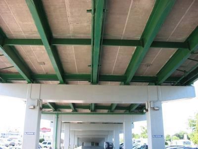
Location. 45° 47.273′ N, 84° 43.932′ W. Marker is in Mackinaw City, Michigan, in Emmet County. Marker can be reached from North Huron Avenue, on the right when traveling west. Marker is attached to a Mackinac Bridge pillar under Interstate 75. Touch for map. Marker is in this post office area: Mackinaw City MI 49701, United States of America. Touch for directions.
Other nearby markers. At least 8 other markers are within walking distance of this marker. Flags of Michilimackinac (here, next to this marker); Revolutionary Times (within shouting distance of this marker); Michigan's First Jewish Settler (within shouting distance of this marker); Crossroads of the Fur Trade (within shouting distance of this marker); Fort Michilimackinac / Michilimackinac State Park (within shouting distance of this marker); The Community Outside the Walls: Suburbs of Michilimackinac (about 500 feet away, measured in a direct line); Ironworkers Walk of Fame (about 600 feet away); Lighthouses of the Mackinac Straits (about 700 feet away). Touch for a list and map of all markers in Mackinaw City.
Regarding Mackinac Bridge. On June 28, 1958, two 30 inch by 34 inch commemorative plaques were attached to Mackinac Bridge pillars south of the entrance to Colonial Michilimackinac in Mackinaw City as part of the formal dedication ceremonies of the Mackinac Bridge. One plaque honors the dignitaries responsible for financing and organizing this historic project and the other honors the five workers who lost their lives while constructing the Mackinac Bridge.
Also see . . .
1. "The Mighty Mac" - History. Mackinac Bridge Authority webpage (Submitted on January 30, 2021, by Larry Gertner of New York, New York.)
2. Mackinac Bridge. Wikipedia entry (Submitted on August 11, 2007, by Keith L of Wisconsin Rapids, Wisconsin.)
3. Mackinac Bridge Walk. Being a farm girl from Montana, I still think driving across Mackinac Bridge is a bit spooky. I have cousins that live in Michigan that take part in the Mackinac Bridge Walk every year. It takes about two hours to walk across. (Submitted on May 27, 2009, by Maria Krauth Minear of Hardin, Montana.)
Additional commentary.
1. About the Bridge
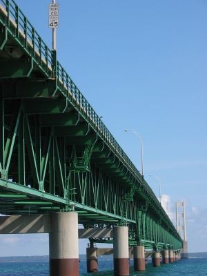
The Mackinac Bridge is currently the third longest suspension bridge in the world; the total length with approaches is 26,372 feet (5 miles). The height of the roadway at mid-span is approximately 200 feet above water level.
Source: Michigan DOT website
— Submitted August 10, 2007, by Keith L of Wisconsin Rapids, Wisconsin.
Photographed By Keith L, August 8, 2006
5. Mackinac Bridge
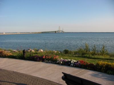
Photo taken at Bridge View Park, St. Ignace. Looking at the causeway and Mackinac Bridge to the lower peninsula (Mackinaw City). From the Michigan Department of Transportation website: "The sheer size and beauty of the Mackinac Straits Bridge still impress first-time viewers. The bridge's total length, 8614 feet, the longest in the western hemisphere, combined with towers standing 552 feet above the water line, a 155 feet clearance under the bridge, and a total weight of 11,840 tons, is indeed an impressive sight." When built it was the longest bridge in the world.
Credits. This page was last revised on January 30, 2021. It was originally submitted on August 5, 2007, by Keith L of Wisconsin Rapids, Wisconsin. This page has been viewed 3,787 times since then and 24 times this year. Photos: 1, 2, 3, 4, 5. submitted on August 5, 2007, by Keith L of Wisconsin Rapids, Wisconsin. • J. J. Prats was the editor who published this page.
