Hollister in Santa Clara County, California — The American West (Pacific Coastal)
History of Sluice Mining
Forty-niners often faced hardships along the way. At first, gold nuggets could be found and picked up off the ground. As more and more miners poured into California and gold continued to be found, they developed new techniques for extracting gold, such as panning and sluice mining. Eventually even more sophisticated methods were developed.
The Gold Rush changed the face of California, turning small settlements into boomtowns. Roads and new towns were established, a state constitution was written, and a governor and legislature were chosen. In 1850, California became the 31st state.
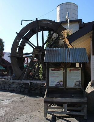
Case de Fruta’s Sluice and Gem Mining is a continuation of a classic mining technique used by forty-niners in California’s early settlement history. Here you will use a stream of water from the water wheel to sift through sand to find hidden gemstones and minerals.
Topics. This historical marker is listed in these topic lists: Exploration • Settlements & Settlers. A significant historical year for this entry is 1849.
Location. 36° 59.285′ N, 121° 22.936′ W. Marker is in Hollister , California, in Santa Clara County. Marker can be reached from Casa de Fruta Parkway near Pacheco Pass Highway (California Route 152). The marker is mounted to in a wood frame next to the water wheel. Touch for map. Marker is at or near this postal address: 10021 Pacheco Pass Highway, Hollister CA 95023, United States of America. Touch for directions.
Other nearby markers. At least 8 other markers are within 10 miles of this marker, measured as the crow flies. Ancient Paths (a few steps from this marker); Bell Station (approx. 5.2 miles away); Rancho San Ysidro / San Ysidro School (approx. 7.8 miles away); Cottage Corners (approx. 8.3 miles away); Site of San Justo Ranch Home (approx. 9.4 miles away); Hollister Train Service (approx. 9½ miles away); William Clyde "Wino Willie" Forkner, Jr. (approx. 9½ miles away); San Benito County Vietnam War Memorial (approx. 9.6 miles away). Touch for a list and map of all markers in Hollister.
Credits. This page was last revised on November 2, 2022. It was originally submitted on November 1, 2022, by Joseph Alvarado of Livermore, California. This page has been viewed 127 times since then and 15 times this year. Photos: 1, 2. submitted on November 1, 2022, by Joseph Alvarado of Livermore, California.

