Douglas in Tucker County, West Virginia — The American South (Appalachia)
Black Fork Grade
One of the most grueling rail operations in North America
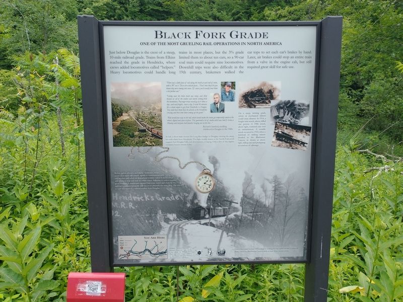
Just below Douglas is the crest of a steep, 10-mile railroad grade. Trains from Elkins reached the grade in Hendricks, where crews added locomotives called “helpers”. Heavy locomotives could handle long trains in most places, but the 3% grade limited them to about ten cars, so a 90-car coal train could require nine locomotives. Downhill trips were also difficult: in the 19th century, brakemen walked the car tops to set each car’s brakes by hand. Later, air brakes could stop an entire train from a valve in the engine cab, but still required great skill for safe use.
“There was a little piece of rail along the track at each end of town, with a “W” on it. Those were whistle posts…That’s how they’d let you know they were coming into town. Of course you’d usually hear them a lot further out.”
“Living near the train track was noisy, and dirty because of all of the cinders and smoke coming from the locomotives. Passenger trains would go by 4 times a day…and coal freights…twice a day. It took 40 minutes for a steam engine to get from Hendricks to Douglas. You could hear them blow the whistle at the Hendricks crossing and then time them coming up the grade.”
“Kids would put soap on the tail, which would make the trains get temporarily stock as the wheels slipped and spun in place. This generated a lot of smoke which was bad if it was a Monday and everyone had laundry hanging out on the line…”
— Richard Crawford, recalling childhood in Douglas in the 1940s.
[Captions:]
At left, a short train crosses the Long Run Bridge in Douglas, cresting the steep, ten-mile climb from Hendricks. The high, muddy waters in the North Fork at left suggest that Douglas Falls, just downstream, is raging. Only a few of the duplex company houses remain today.
On a steep, twisting grade, errors or mechanical failures could cause disaster. In 1914, a freight train wreck, above, killed one person. A 1906 wreck, above right, scattered cars over an embankment. A notable wreck occurred in 1922, when a trainload of striking miners derailed in the Blackwater Canyon, as shown at above right, killing one and prompting accusations off sabotage.
Before radios, phones, and digital electronics, train crews used hand and whistle signals to communicate with one another and relied on dispatchers’ written orders to know when and where to stop and wait for other trains. Adhering to orders required good watches. A timekeeper ensured that every watch and clock on the railroad functioned properly and was set to precisely the same time. The watch at right belonged to a railroad worker from Douglas.
Here, a few years before 1900, a train is
making its way uphill around a series of sharp curves in Blackwater Canyon with at least three locomotives.
Topics. This historical marker is listed in these topic lists: Communications • Industry & Commerce • Railroads & Streetcars. A significant historical year for this entry is 1914.
Location. 39° 7.587′ N, 79° 31.108′ W. Marker is in Douglas, West Virginia, in Tucker County. Marker is on Rail Falls Road (County Road 27/3) one mile south of Douglas Road (County Road 27), on the right when traveling north. Touch for map. Marker is at or near this postal address: 117 Locomotive Ln, Thomas WV 26292, United States of America. Touch for directions.
Other nearby markers. At least 8 other markers are within 2 miles of this marker, measured as the crow flies. Douglas, W. Va. (about 600 feet away, measured in a direct line); Reclaiming the Future (approx. 0.4 miles away); Creating Coke, Created More Than Smoke (approx. 0.4 miles away); From Coal to Coke (approx. half a mile away); Mine Portal No. 29 (approx. 0.8 miles away); Coketon Colored School (approx. 1.3 miles away); Engineering Building (approx. 1.3 miles away); The Company Store (approx. 1.3 miles away).
Credits. This page was last revised on November 15, 2022. It was originally submitted on November 11, 2022, by Tom Bosse of Jefferson City, Tennessee. This page has been viewed 209 times since then and 43 times this year. Photos: 1, 2. submitted on November 11, 2022, by Tom Bosse of Jefferson City, Tennessee. • Devry Becker Jones was the editor who published this page.

