Near Powhatan in Powhatan County, Virginia — The American South (Mid-Atlantic)
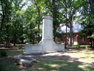
The Huguenot Monument
(center panel) This memorial erected by The Huguenot Society of the Founders of Manakin in the Colony of Virginia 1936 Dedicated April 1937
(right panel) King William Parish Manakintowne Church authorized by an act of the General Assembly held at Williamsburg, Virginia, December 5, 1700
Erected 1937 by The Huguenot Society of the Founders of Manakin in the Colony of Virginia.
Topics. This historical marker and monument is listed in these topic lists: Churches & Religion • Settlements & Settlers. A significant historical date for this entry is April 13, 1612.
Location. 37° 33.921′ N, 77° 42.529′ W. Marker is near Powhatan, Virginia, in Powhatan County. Marker can be reached from Huguenot Trail, 0.3 miles east of Manakin Town Ferry Road, on the right when traveling east. Touch for map. Marker is in this post office area: Midlothian VA 23113, United States of America. Touch for directions.
Other nearby markers. At least 8 other markers are within 3 miles of this marker, measured as the crow flies. Mowhemcho-Manakin Town (within shouting distance of this marker); Huguenot Settlement (within shouting distance of this marker); Huguenot Springs Confederate Cemetery (approx. 0.4 miles away); Huguenot Springs (approx. half a mile away); Our Confederate Dead (approx. half a mile away); Terre Haute Farm African American Cemetery (approx. ¾ mile away); a different marker also named Huguenot Settlement (approx. 2½ miles away); First Baptist Church (approx. 2½ miles away). Touch for a list and map of all markers in Powhatan.
Also see . . . The Huguenot Society of the Founders of Manakin In the Colony of Virginia. (Submitted on July 26, 2009.)

Photographed By Bernard Fisher, July 25, 2009
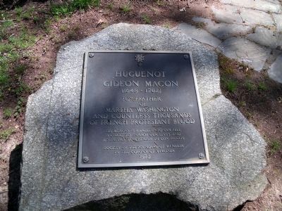
2. Macon Memorial
Huguenot Gideon Macon (1648 -1702) forefather of Martha Washington and countless thousands of French and Protestant blood. His memory is a light unto our feet, a chart to enrich our lives, and a heritage to cherish in our hearts. Society of the Founders of Manakain in the Colony of Virginia 1973
Credits. This page was last revised on November 11, 2021. It was originally submitted on July 26, 2009, by Bernard Fisher of Richmond, Virginia. This page has been viewed 1,921 times since then and 79 times this year. Photos: 1, 2, 3, 4. submitted on July 26, 2009, by Bernard Fisher of Richmond, Virginia.


