Fairmount in Grant County, Indiana — The American Midwest (Great Lakes)
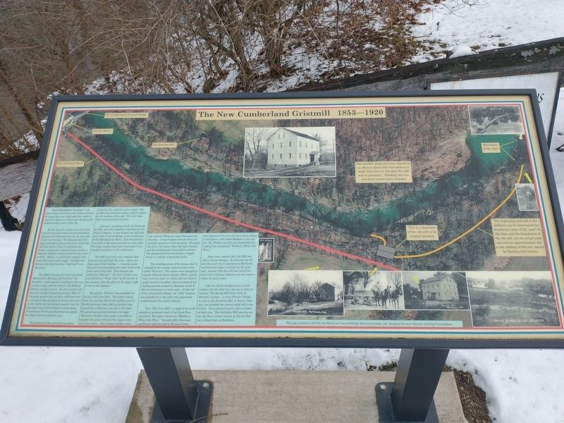
The New Cumberland Gristmill 1853-1920
This "Northwest Territory" was dense forest when the early settlers arrived. It is said that one could walk from what is now Fort Wayne to what is now Indianapolis without seeing much of the sky.
By the time the settler had cleared his land of trees and brush and had laboriously planted and cultivated his crop, he next had to harvest the crop. The demand grew for a local gristmill to process the grain. Until this mill was built at New Cumberland, the farmer was forced to haul his grain as far as Wabash, Indiana to have it ground into meal or flour. Horse or mule-drawn wagons over roads that were really rough - initially just forest trails that had been "improved" over the years.
The Miller became the most important link between farming and industry. He, therefore, rated superior standing in the community, along with the Parson, the Medical Doctor, and the Lawyer. He set a service toll. for every bushel of grain he ground. Most of the early settlers did not have sufficient money to pay for the grinding in dollars and cents, so the miller set the fee and, usually, was the principal buyer of the farmer's excess grain. A customary fee for grinding was one-eighth for wheat and one-sixth for corn.
The location of the gristmill was determined by the available water supply. The traffic of an entire township could be judged by the location of the mill. The mill roads were always heavily traveled.
Dennison and Kisner built the Gristmill in 1853, with the carpentry work done by the Dunn Company. It was located one half mile east of the Covered Bridge on the south bank of the Mississinewa River. This old gristmill was built on the same principle as most mills. The huge timbers that were used made it the sturdiest structure in the community.
The Mill was built over a channel that was constructed from the river - above the dam east of the building, running under the mill and exhausting the water back to the river west of the mill. This channel was called the "Millrace". The flow of water was controlled by a "Water Gate” at the mouth of the raceway. (See the photo at the upper-right corner of this display.)
The sturdy "Turbine” was installed under the mill's first floor. The water coming down the raceway forced the turbine around. Shafts and gears led to the equipment that housed the millstones, one above the other. The grain was ground between two large "Burr-stone” holders that made it possible to regulate the space between the upper stone and lower stone. Also a large wooden crane was used for lifting the upper burr-stone for cleaning. A large hopper that sat above the grinding equipment held the grain. The grain was fed to the upper stone through a funnel, and the crushed grain was spilled outward. The ground meal was forced into a hopper where it could be scooped into sacks.
The crushing action of the stones was increased by the cutting of grooves that were called "Furrows". The stones were changed to handle different kinds of grain. Often, special days were set aside on which only one kind of grain would be handled. Improvements of the milling methods helped to eliminate much of this inconvenience in later years. At the end of the nineteenth century, the "roller" process was introduced in the mills that practically revolutionized the entire industry.
This "Old Town Mill", in spite of its crude operation, produced some of the finest flour anywhere. The name brand was "Matthews White Lilly Flour." Around 1860, Dennison and Kisner sold the mill to Thomas Dunn, who operated it for several years before selling to Ed Harms, with John Walters as the miller. Mr. Walters was the man responsible for making the remarkable "Matthews White Lilly Flour."
Some time, around 1915, the Mill was sold to George Morgan. By this time the Elliott Elevator was in operation in Matthews, and business began to decline for the gristmill. Around 1920 the mill was moved to a farm west of Gaston, Indiana and was used as a barn for many years.
Like the slowly-disappearing covered bridges, the old mills have become a rarity in Indiana. The Spring Mill State Park, at Mitchell, Indiana - in their Pioneer Village - as well as the Stockdale Mill, at Roann, Indiana, are probably the nearest mills still in operation. Stone-ground meal is still available at both sites. The Stockdale Mill uses the under-the-floor turbine, similar to the one that was utilized here at Matthews.
Erected 2013 by Matthews County Historical Society.
Topics. This historical marker is listed in these topic lists: Bridges & Viaducts • Industry & Commerce. A significant historical year for this entry is 1853.
Location. 40° 23.298′ N, 85° 29.103′ W. Marker is in Fairmount, Indiana, in Grant County. Marker can be reached from the intersection of 3rd Street and Front Street, on the right when traveling north. Touch for map. Marker is at or near this postal address: 301 E Main St, Fairmount IN 46928, United States of America. Touch for directions.
Other nearby markers. At least 8 other markers are within 5 miles of this marker, measured as the crow flies. Cumberland Covered Bridge (here, next to this marker); This Covered Bridge (a few steps from this marker); Matthews Veterans Memorial (about 800 feet away, measured in a direct line); Lt. Col. Thomas W. (Bill) Boles (about 800 feet away); Covered Bridge (approx. 0.2 miles away); Elizabethtown (approx. 1.8 miles away); The Village of Trask (approx. 3.1 miles away); In Memory Of William J. Leach (approx. 4.7 miles away).
Credits. This page was last revised on February 8, 2023. It was originally submitted on January 30, 2023, by Craig Doda of Napoleon, Ohio. This page has been viewed 123 times since then and 37 times this year. Photos: 1, 2, 3. submitted on January 30, 2023, by Craig Doda of Napoleon, Ohio. • Devry Becker Jones was the editor who published this page.


