Oak Ridge in Anderson County, Tennessee — The American South (East South Central)
Grove Center
A Place of Welcome Distraction and Escape
— Manhattan Project National Historical Park —
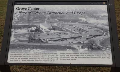
Centrally located between Jackson Square and Jefferson Center, Grove Center was one of three large commercial areas built for residents of Clinton Engineer Works in need of a place to run everyday errands and escape from the stressful demands of work. Grove Center stores included Tulip Town Super Market, Wender’s Men’s Shop and Burton’s Shoe Renewery. Of special note was the 1,000-seat Grove Theater, which opened on September 28, 1944.
Residents could enjoy a movie for 35 cents (11 cents for kids), or enjoy a concert. The carefully designed theater produced superb acoustics. In its early years, a variety of renowned and talented musicians played here, including world-famous violinist Isaac Stern, the Oak Ridge Boys gospel group, and more.
Erected by National PArk Service / U.S. Department of the Interior.
Topics. This historical marker is listed in these topic lists: Entertainment • Settlements & Settlers • War, World II. A significant historical date for this entry is September 28, 1944.
Location. 36° 0.861′ N, 84° 15.944′ W. Marker is in Oak Ridge, Tennessee, in Anderson County. Marker is on Randolph Road. Touch for map. Marker is at or near this postal address: 134 Randolph Rd, Oak Ridge TN 37830, United States of America. Touch for directions.
Other nearby markers. At least 8 other markers are within walking distance of this marker. The Swimming Hole (about 500 feet away, measured in a direct line); Midtown Community Center (about 600 feet away); Oak Ridge Municipal Outdoor Swimming Pool (about 700 feet away); The Emery Road (about 700 feet away); International Friendship Bell (approx. ¼ mile away); Y-12 – The Calutron Plant (approx. 0.4 miles away); 1948 (approx. 0.4 miles away); Oak Ridge Hospital (approx. 0.4 miles away). Touch for a list and map of all markers in Oak Ridge.
Credits. This page was last revised on February 4, 2023. It was originally submitted on February 1, 2023, by Dave W of Co, Colorado. This page has been viewed 80 times since then and 16 times this year. Photo 1. submitted on February 1, 2023, by Dave W of Co, Colorado. • Bill Pfingsten was the editor who published this page.
