Clawson in Oakland County, Michigan — The American Midwest (Great Lakes)
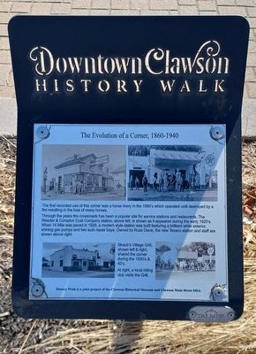
The Evolution of a Corner, 1860-1940
Downtown Clawson History Walk
The first recorded use of this corner was a horse livery in the 1880's which operated until destroyed by a fire resulting in the loss of many horses.
Through the years the crossroads has been a popular site for service stations and restaurants. The Weeder & Compton Coal Company station, above left, is shown as it appeared during the early 1920's. When 14 Mile was paved in 1928, a modern style station was built featuring a brilliant white exterior, shining gas pumps and two auto repair bays. Owned by Russ Davis, the new Texaco station and staff are shown above right.
Staub's Village Grill, shown left & right, shared the corner during the 1930's & 1940's.
At right, a local riding club visits the Grill.
History Walk is a joint project of the Clawson Historical Museum and Clawson Main Street DDA
Erected by Clawson Historical Museum and Clawson Main Street DDA.
Topics. This historical marker is listed in this topic list: Industry & Commerce. A significant historical year for this entry is 1928.
Location. 42° 32.015′ N, 83° 8.807′ W. Marker is in Clawson, Michigan, in Oakland County. Marker is at the intersection of 14 Mile Road and Main Street, on the right when traveling west on 14 Mile Road. Touch for map. Marker is at or near this postal address: 20 West 14 Mile Road, Clawson MI 48017, United States of America. Touch for directions.
Other nearby markers. At least 8 other markers are within walking distance of this marker. The Interurban 1899-1931 (within shouting distance of this marker); Evolution of a Corner, 1900-1940 (within shouting distance of this marker); Interurban Railroads in Michigan 1899-1931 (within shouting distance of this marker); First City Hall (within shouting distance of this marker); 1 East 14 Mile (within shouting distance of this marker); 20th Century Progress (within shouting distance of this marker); Clawson State Savings Bank (within shouting distance of this marker); Snapshot of Clawson, 1920s (within shouting distance of this marker). Touch for a list and map of all markers in Clawson.
Credits. This page was last revised on February 16, 2023. It was originally submitted on February 16, 2023, by Joel Seewald of Madison Heights, Michigan. This page has been viewed 56 times since then and 9 times this year. Photos: 1, 2. submitted on February 16, 2023, by Joel Seewald of Madison Heights, Michigan.

