Middlesex Township near Carlisle in Cumberland County, Pennsylvania — The American Northeast (Mid-Atlantic)
No Man's Land
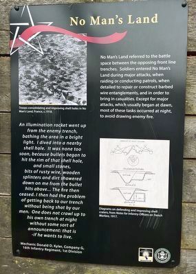
No Man's Land referred to the battle space between the opposing front line trenches. Soldiers entered No Man's Land during major attacks, when raiding or conducting patrols, when detailed to repair or construct barbed wire entanglements, and in order to bring in casualties. Except for major attacks, which usually began at dawn, most of these tasks occurred at night, to avoid drawing enemy fire.
An illumination rocket went up from the enemy trench, bathing the area in a bright light. I dived into a nearby shell hole. It was none too soon, because bullets began to hit the rim of that shell hole, and small stones, bits of rusty wire, wooden splinters and dirt showered down on me from the bullet hits above… The fire then ceased. I then had the problem of getting back to our trench without being shot by our men. One does not crawl up to his own trench at night without some sort of announcement: that is -if he wants to live.
Mechanic Donald D. Kyler, Company G, 16th Infantry Regiment, 1st Division
[Captions:]
Troops consolidating and improving shell holes in No Man's Land, France, c. 1918.
Diagrams on defending and improving shell craters, from Notes for Infantry Officers on Trench Warfare, 1917.
Erected by The United States Army War College; United States Army Heritage and Education Center.
Topics. This historical marker is listed in this topic list: War, World I. A significant historical year for this entry is 1918.
Location. 40° 12.388′ N, 77° 9.483′ W. Marker is near Carlisle, Pennsylvania, in Cumberland County. It is in Middlesex Township. Marker is on Army Heritage Trail south of Soldiers Drive, on the right when traveling south. Touch for map. Marker is at or near this postal address: 95 Soldiers Dr, Carlisle PA 17013, United States of America. Touch for directions.
Other nearby markers. At least 8 other markers are within walking distance of this marker. Machine Gun Post (here, next to this marker); Splinter Proof (here, next to this marker); Sniper's Nest (a few steps from this marker); The Mortar Pit (a few steps from this marker); The Front (a few steps from this marker); Command Post (a few steps from this marker); Aid Station (a few steps from this marker); Meet Mechanic Donald D. Kyler (a few steps from this marker). Touch for a list and map of all markers in Carlisle.
Related marker. Click here for another marker that is related to this marker. - The original marker at this location.
Credits. This page was last revised on December 18, 2023. It was originally submitted on March 1, 2023, by Devry Becker Jones of Washington, District of Columbia. This page has been viewed 69 times since then and 17 times this year. Photos: 1, 2. submitted on March 1, 2023, by Devry Becker Jones of Washington, District of Columbia.

