Brownsville in Cameron County, Texas — The American South (West South Central)
Border War
Resaca de la Palma Battlefield
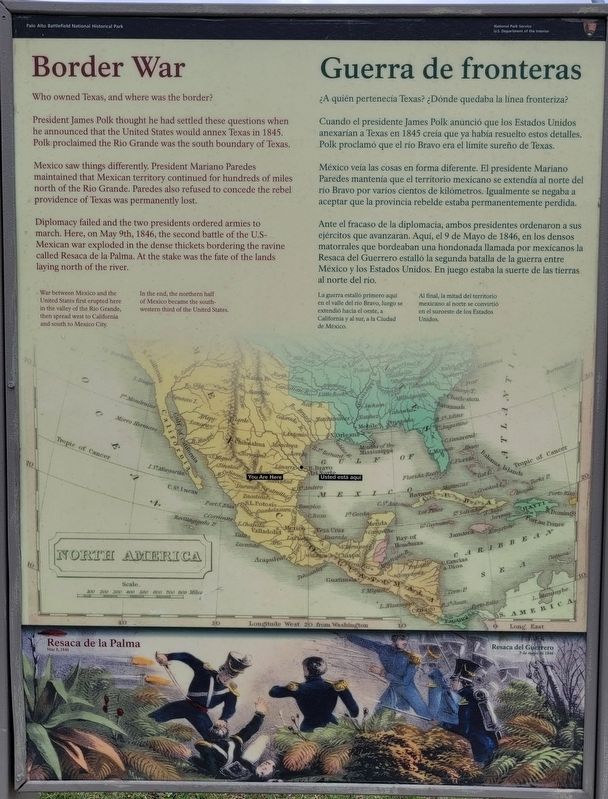
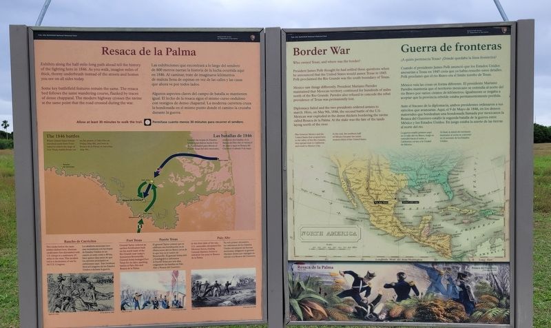
President James Polk thought he had settled these questions when he announced that the United States would annex Texas in 1845. Polk proclaimed the Rio Grande was the south boundary of Texas.
Mexico saw things differently. President Mariano Paredes maintained that Mexican territory continued for hundreds of miles north of the Rio Grande. Paredes also refused to concede the rebel providence of Texas was permanently lost.
Diplomacy failed and the two presidents ordered armies to march. Here, on May 9th, 1846, the second battle of the U.S-Mexican war exploded in the dense thickets bordering the ravine called Resaca de la Palma. At the stake was the fate of the lands laying north of the river.
War between Mexico and the United States first erupted here in the valley of the Rio Grande, then spread west to California and south to Mexico City.
In the end, the northern half of Mexico became the south-western third of the United States.
Captions
Resaca de la Palma
May 8, 1846
Spanish:
¿A quién pertenecía Texas? ¿Dónde quedaba la línea fronteriza?
Cuando el presidente James Polk anunció que los Estados Unidos anexarían a Texas en 1845 creía que ya había resuelto estos detalles. Polk proclamó que el río Bravo era el límite sureño de Texas.
México veía las cosas en forma diferente. El presidente Mariano Paredes mantenía que el territorio mexicano se extendía al norte del río Bravo por varios cientos de kilómetros. Igualmente se negaba a aceptar que la provincia rebelde estaba permanentemente perdida.
Ante el fracaso de la diplomacia, ambos presidentes ordenaron a sus ejércitos que avanzaran. Aquí, el 9 de Mayo de 1846, en los densos matorrales que bordeaban una hondonada llamada por mexicanos la Resaca del Guerrero estalló la segunda batalla de la guerra entre México y los Estados Unidos. En juego estaba la suerte de las tierras al norte del río.
La guerra estalló primero aquí en el valle del río Bravo, luego se extendió hacia el oeste, a California y al sur, a la Ciudad de México.
Al final, la mitad del territorio mexicano al norte se convirtió en el suroeste de los Estados Unidos.
Subtítulos
Resaca del Guerrero
9 de mayo de 1846
Erected by National Park Service - U.S. Department of the
Interior.
Topics. This historical marker is listed in this topic list: War, Mexican-American. A significant historical date for this entry is May 9, 1846.
Location. 25° 56.348′ N, 97° 29.24′ W. Marker is in Brownsville, Texas, in Cameron County. Marker can be reached from the intersection of Paredes Line Road and Palo Verde Drive. The marker is located along the northwest section of the Resaca de la Palma trail. Touch for map. Marker is at or near this postal address: 1024 Paredes Line Road, Brownsville TX 78521, United States of America. Touch for directions.
Other nearby markers. At least 8 other markers are within walking distance of this marker. Resaca de la Palma (here, next to this marker); The Resaca de la Palma Battlesite (within shouting distance of this marker); Monumental History (within shouting distance of this marker); A Daunting Defense (about 400 feet away, measured in a direct line); Take the Cannon! (about 500 feet away); The Battle of Resaca de la Palma (about 500 feet away); Into the Mexican Camp (about 700 feet away); Hand-to-Hand (about 800 feet away). Touch for a list and map of all markers in Brownsville.
More about this marker. The battlefield and the markers are located on the grounds of the Resaca de la Palma National Historical Park which is free to access.
Also see . . . Resaca de la Palma Battlefield. National Park Service - Department of the Interior
Resaca de la Palma, also known as Resaca de Guerrero, is an old, dry river channel of the Rio Grande. It is one of many long, water-filled ravines left behind by the shifting course of the winding river. The old pathway was lined with dense brush and its bed was dotted with pools of water. The Mexican Army hoped these natural features would limit any attack against troops positioned there.(Submitted on April 26, 2023, by James Hulse of Medina, Texas.)
Credits. This page was last revised on April 26, 2023. It was originally submitted on April 26, 2023, by James Hulse of Medina, Texas. This page has been viewed 62 times since then and 15 times this year. Photos: 1, 2, 3. submitted on April 26, 2023, by James Hulse of Medina, Texas.


