Greeley in Weld County, Colorado — The American Mountains (Southwest)
Transportation
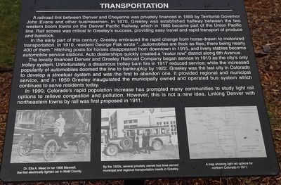
A railroad link between Denver and Cheyenne was privately financed in 1869 by Territorial Governor John Evans and other businessmen. In 1870, Greeley was established halfway between the two western boom towns on the Denver Pacific Railway, which in 1880 became part of the Union Pacific line. Rail access was critical to Greeley's success, providing easy travel and rapid transport of produce and livestock.
In the early part of this century, Greeley embraced the rapid change from horse-drawn to motorized transportation. In 1910, resident George Fisk wrote "...automobiles are thick as flies, there being nearly 400 of them." Hitching posts for horses disappeared from downtown in 1915, and livery stables became automobile service stations. Auto dealerships quickly created a "motor row" district along 8th Avenue.
The locally financed Denver and Greeley Railroad Company began service in 1910 as the city's only trolley system. Unfortunately, a disastrous trolley barn fire in 1917 reduced service; while the increased popularity of automobiles doomed the line to bankruptcy by 1922. Greeley was the last city in Colorado to develop a streetcar system and was the first to abandon one. It provided regional and municipal service, and in 1959 Greeley inaugurated the municipally owned and operated bus system which continues to serve residents today.
In 1990, Colorado's rapid population increase has prompted many communities to study light rail options to relieve congestion and pollution. However, this is not a new idea. Linking Denver with northeastern towns by rail was first proposed in 1911.
Topics. This historical marker is listed in these topic lists: Industry & Commerce • Railroads & Streetcars. A significant historical year for this entry is 1869.
Location. 40° 25.436′ N, 104° 41.323′ W. Marker is in Greeley, Colorado, in Weld County. Marker is on 7th Avenue, on the right when traveling north. Touch for map. Marker is at or near this postal address: 902 7th Avenue, Greeley CO 80631, United States of America. Touch for directions.
Other nearby markers. At least 8 other markers are within walking distance of this marker. Agriculture (here, next to this marker); Greeley Historic Overview (here, next to this marker); Greeley Union Pacific Railroad Depot (a few steps from this marker); Greeley Business District (a few steps from this marker); Immigration (a few steps from this marker); Buckingham Gordon Building (approx. 0.2 miles away); State Armory (approx. 0.2 miles away); Weld County Court House (approx. 0.2 miles away). Touch for a list and map of all markers in Greeley.
Credits. This page was last revised on May 6, 2023. It was originally submitted on May 5, 2023, by Dave W of Co, Colorado. This page has been viewed 57 times since then and 19 times this year. Photos: 1, 2. submitted on May 5, 2023, by Dave W of Co, Colorado. • Andrew Ruppenstein was the editor who published this page.

