Montpelier in Washington County, Vermont — The American Northeast (New England)
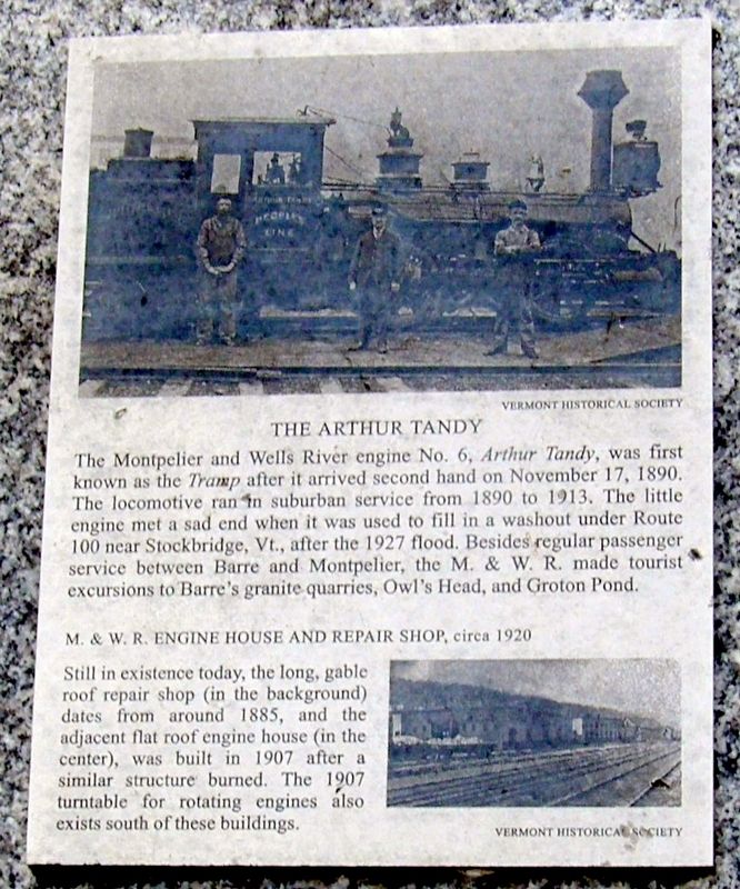
The Arthur Tandy
The Montpelier and Wells River engine No. 6, the Arthur Tandy, was first known as the Tramp after it arrived second hand on November 17, 1890. The locomotive ran in suburban service from 1890 to 1913. The little engine met a sad end when it was used to fill a washout under Route 100 near Stockbridge Vt., after the 1927 flood. Besides regular passenger service between Barre and Montpelier, the M. & W.R. made tourist excursions to Barre’s granite quarries, Owl’s Head, and Groton Pond.
M.& W.R. Engine House and Repair Shop, circa 1920
Still in existence today, the long, gable roof repair shop (in the background) dates from around 1885, and the adjacent flat roof engine house (in the center), was built in 1907 after a similar structure burned. The 1907 turntable for rotating engines also exists south of these buildings.
Topics. This historical marker is listed in this topic list: Railroads & Streetcars. A significant historical date for this entry is November 17, 1890.
Location. 44° 15.295′ N, 72° 34.377′ W. Marker is in Montpelier, Vermont, in Washington County. Marker can be reached from Stone Cutters Way, on the right when traveling north. Touch for map. Marker is at or near this postal address: near 535 Stone Cutters Way, Montpelier VT 05602, United States of America. Touch for directions.
Other nearby markers. At least 8 other markers are within walking distance of this marker. Railroad Turntable, circa 1907 (within shouting distance of this marker); Main Street Bridge & F.W. Bailey Mill, Circa 1920 (approx. 0.2 miles away); Winooski River From Bailey’s Grain Tower, 1929 (approx. 0.2 miles away); Flood of 1927, Montpelier and Wells River Railroad Station and Yard (approx. 0.2 miles away); Site of the Caldwell House (approx. 0.4 miles away); Senator William Upham (approx. half a mile away); Lafayette’s Tour / Le Tour De Lafayette (approx. 0.6 miles away); Vermont Equality For Same-Sex Couples (approx. 0.6 miles away). Touch for a list and map of all markers in Montpelier.
Credits. This page was last revised on July 8, 2023. It was originally submitted on May 20, 2023, by Larry Gertner of New York, New York. This page has been viewed 62 times since then and 16 times this year. Photos: 1, 2. submitted on May 20, 2023, by Larry Gertner of New York, New York.

