Sullivan's Island in Charleston County, South Carolina — The American South (South Atlantic)
Rear Gate & Second Post Chapel
Fort Moultrie Military Reservation
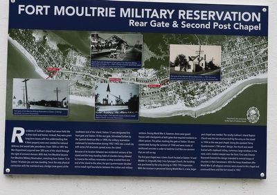
Residents of Sullivan’s Island had never held title to their land and homes. Instead, they were given long-term leases with the understanding that if their property were ever needed for national defense, that would take precedence. From 1895 to 1897 the War Department acquired over 300 acres of the island through the right of eminent domain. With that, Fort Moultrie became Fort Moultrie Military Reservation, stretching from station 12 to Station 18 where you are now standing. Since the only physical connection to the mainland was a bridge (now gone) at the southwest end of the island, Station 12 was designated the front gate and Station 18 the rear gate. Stimulated further by the Spanish-American War in 1898, the military reservation continued its transformation during 1902-1903 into a small city with some 250 structures spread across the island.
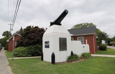
Because of its location between two residential sections of the island and the long-standing habit of islanders being allowed to traverse the military reservation as they traveled from one end of the island to the other, the post quartermaster decided not to install rigid boundaries between the civilian and military sections. During World War II, however, the were guard houses with checkpoints at both gates that required residents to obtain passes. These pillars marked the gate at Station 18 were constructed during the summer of 940 and were made of reinforced concrete in order to hold the Civil War era cannons that are still on top.
The first post chapel was a stone church located at Station 14 and Middle St. Originally Holy Cross Episcopal Church, the building was purchased by the army during its 1902-1903 expansion. With the increase in personnel during World War II, a new, larger post chapel was needed. The nearby Sullivan’s Island Baptist Church was the last structure built by the army on the island in 1944 as the new post chapel. Using the standard “Army Quartermaster’s 700-series” design, the church was wood-framed with clapboard siding, numerous large windows in the nave, and a modest steeple near the front. First Lady Eleanor Roosevelt favored this design intended to remind troops of churches in their hometowns. With the troop drawdown after World War II, all religious services were moved to this chapel and continued there until the fort closed in 1947.
Erected by The Town of Sullivan's Island.
Topics. This historical marker is listed in this topic list: Military. A significant historical year for this entry is 1902.
Location. 32° 45.559′ N, 79° 50.728′ W. Marker is on Sullivan's Island, South Carolina, in Charleston County. Marker is at the intersection of Middle Street and Station 18 Street, on the right when traveling west on Middle Street. Touch for map. Marker is at or near this postal address: 1753 Central Ave, Sullivans Island SC 29482, United States of America. Touch for directions.
Other nearby markers. At least 8 other markers are within walking distance of this marker. Fort Moultrie (a few steps from this marker); Sullivan's Island Life-Saving Station (about 500 feet away, measured in a direct line); US Coast Guard Historic District (approx. 0.2 miles away); Charleston Light (approx. 0.2 miles away); The Valor of Jimmie Dyess on Sullivan's Island and in Combat / The Remarkable Story of Jimmie Dyess (approx. ¼ mile away); Parade Ground and Flagpole Area (approx. ¼ mile away); Civilian Conservation Corps (approx. 0.3 miles away); Sergeant Jasper (approx. 0.3 miles away). Touch for a list and map of all markers in Sullivan's Island.
Credits. This page was last revised on June 5, 2023. It was originally submitted on May 22, 2023, by Dave W of Co, Colorado. This page has been viewed 101 times since then and 17 times this year. Last updated on June 5, 2023, by Bradley Owen of Morgantown, West Virginia. Photos: 1, 2. submitted on May 22, 2023, by Dave W of Co, Colorado. • Bernard Fisher was the editor who published this page.

