Tyrone Township in Blair County, Pennsylvania — The American Northeast (Mid-Atlantic)
The 1976 Bicentennial Reconstruction
Fort Roberdeau
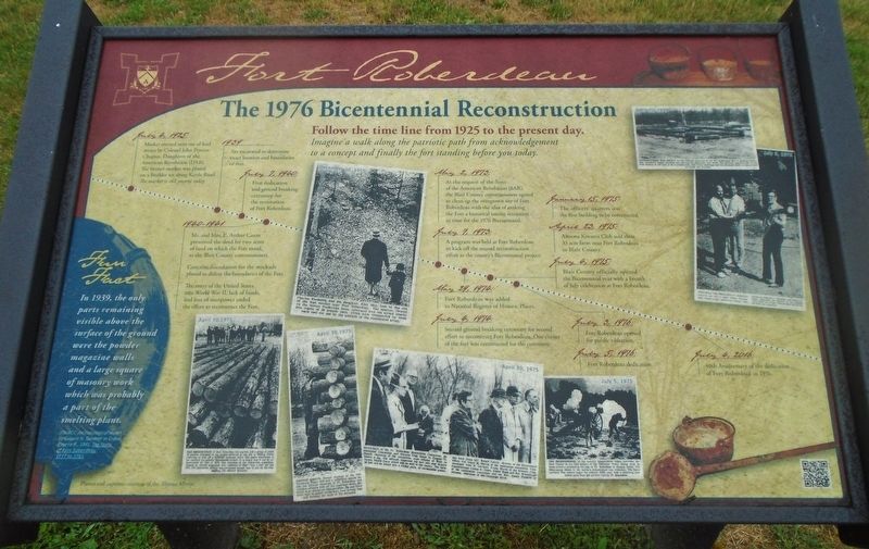
Follow the time line from 1925 to the present day.
Imagine a walk along the patriotic path from acknowledgement to a concept and finally the fort standing before you today.
July 4, 1925
Marker erected near site of lead mines by Colonel John Proctor Chapter, Daughters of the American Revolution (DAR). The bronze marker was placed on a boulder set along Kettle Road.
The marker is still present today.
1939
Site excavated to determine exact location and boundaries of fort.
July 7, 1940:
First dedication and ground breaking ceremony for the restoration of Fort Roberdeau.
1940-1941
Mr. and Mrs. E. Arthur Caum presented the deed for two acres of land on which the Fort stood, to the Blair County commissioners.
Concrete foundation for the stockade placed to define the boundaries of the Fort.
The entry of the United States into World War II, lack of funds, and loss of manpower ended the effort to reconstruct the Fort.
May, 29, 1974:
Fort Roberdeau was added to National Register of Historic Places.
July 4, 1974:
Second ground breaking ceremony for second effort to reconstruct Fort Roberdeau. One corner of the fort was constructed for the ceremony.
January 15, 1975:
The officers' quarters was the first building to be constructed.
April 23, 1975:
Altoona Kiwanis Club sold their 33 acre farm near Fort Roberdeau to Blair County.
May 2, 1975:
At the request of the Sons of the American Revolution (SAR), the Blair County commissioners agreed to clean up the overgrown site of Fort Roberdeau with the idea of making the Fort a historical tourist attraction in time for the 1976 Bicentennial.
July 7, 1975:
A program was held at Fort Roberdeau to kick off the second reconstruction effort as the county's Bicentennial project.
July 4, 1975:
Blair County officially opened the Bicentennial year with a Fourth of July celebration at Fort Roberdeau.
July 3, 1976:
Fort Roberdeau opened for public visitation.
July 5, 1976:
Fort Roberdeau dedication.
July 4, 2016
40th Anniversary of the dedication of Fort Roberdeau in 1976.
Fun Fact
In 1939, the only parts remaining visible above the ground were the powder magazine walls and a large square of masonry work which was probably a part of the smelting plant.
[Photo captions, by date, read]
December 10, 1955
Charles Frederick and his daughter, Alice
May, look at the site of the lead smelter near Fort Roberdeau. The smelter, located on the former Fredericks farm, processed lead ore mined nearby into ingots of 50 pounds each, which were transported by mule back east for use by the soldiers of the [C]ontinental [A]rmy.
April 25, 1975
CONSTRUCTION HAS BEGUN on the officers' quarters at the Ft. Roberdeau site in Sinking Valley. The contractor began notching and placing the logs early last week. The officers' quarters will be the first section of the fort to be reconstructed, with other buildings and the stockade walls to follow later as funds are provided.
April 30, 1975
THE RESTORATION of Fort Roberdeau has started, and a group of about 40 persons interested in the project gathered at the site in Sinking Valley yesterday to kick off a $100,000 campaign drive. The fort's restoration is the county's top priority Bicentennial project. It is hoped that it can be reconstructed by July 4, 1976. The chairman of the restoration committee, Eugene G. Hamill, suggested that residents of Blair "buy a log" for the fort. The committee already has purchased enough logs to put up the first building, the officers' barracks.
April 30, 1975
ERNEST GROVE, former employe [sic] of the Williamsburg Paper Mill and a carpenter, stands beside the officers' barracks at Ft. Roberdeau and watches officials kick off the campaign drive. Mr. Grove is in charge of reconstruction. He and three other men in recent weeks have been hewing logs and building the walls of the barracks.
April 30, 1975
OFFICIALS of the Ft. Roberdeau Restoration Committee, Bicentennial Commission and Kiwanis Club listen to Eugene G. Hamill, chairman of the committee, urge citizens of Blair to finance a log. The officials inspected the fort site and 33-acre Kiwanis Health Farm which will be sold to the county. The farm and fort will be joined into a county park. At ceremonies yesterday were (from lef[t]): Robert Lauver, director of the bicentennial office; Col. Lloyd M. Morris of the restoration committee, Commissioner John W. Gardner, Frank Marsh of the Kiwanis Club, Commissioner Colson E. Jones, Elmer Reed and Rev. Brumbaugh of the restoration committee and the Rev. James Plunkett of Altoona, chairman of the campaign drive.
July 3, 1975
PREPARING FOR PROGRAM at Ft. Roberdeau tomorrow are (left to right): Robert Warsing, Blair County grants coordinator; County Commissioners Edward J. Flanagan and Colson E. Jones, inspecting the halyard [?] from which the 13-star Colonial flag [that will fly?] the first time tomorrow.
July 5, 1975
THE BICENTENNIAL of the nation's independence began yesterday for Blair County as the field battery of the Tuckahoe Valley Militia fired 13 times across a cornfield to the rear of Ft. Roberdeau in Sinking Valley. The Bicentennial salute to the nation's independence was underway. The Revolutionary War cannon began the nation's 200th year with a deafening roar before more than 400 persons visiting Ft. Roberdeau.
Erected by the Fort Roberdeau Association.
Topics. This historical marker is listed in these topic lists: Charity & Public Work • Forts and Castles • War, US Revolutionary. A significant historical date for this entry is July 5, 1975.
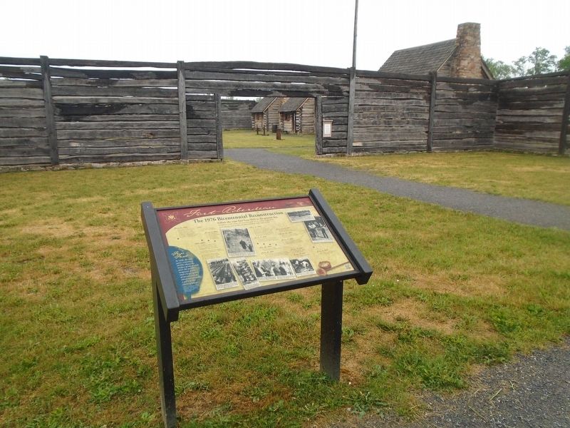
Location. 40° 34.954′ N, 78° 16.448′ W. Marker is in Tyrone Township, Pennsylvania, in Blair County. Marker is near the entrance to Fort Roberdeau. Touch for map. Marker is at or near this postal address: 383 Fort Roberdeau Road, Altoona PA 16601, United States of America. Touch for directions.
Other nearby markers. At least 8 other markers are within 7 miles of this marker, measured as the crow flies. "The Lead Mine Fort" (a few steps from this marker); The Three Sisters (within shouting distance of this marker); Conestoga Wagon & Pennsylvania Barn (within shouting distance of this marker); Fort Roberdeau (approx. 2.4 miles away); Arch Springs Cemetery (approx. 4˝ miles away); "The Big Spring" (approx. 6.4 miles away); First Building (approx. 6.4 miles away); Site of the Former Historic City Hotel (approx. 6.4 miles away). Touch for a list and map of all markers in Tyrone Township.
Also see . . . Fort Roberdeau Historic Site. (Submitted on June 26, 2023, by William Fischer, Jr. of Scranton, Pennsylvania.)
Additional commentary.
1.
Daughters of the American Revolution bronze marker placed on a boulder set along Kettle Road is located at N 40° 34.191 W 078° 16.27. Inscription:
400 Feet North of this Marker is the site of The Lead Mines. These Mines Furnished Much Of the Lead Used by General Washington's Army During The Revolution.
Placed By Colonel John Proctor Chapter D.A.R., Altoona, Pa., 1925
— Submitted March 20, 2024, by Carolyn Sanders of Plano, Texas.
Credits. This page was last revised on March 24, 2024. It was originally submitted on June 26, 2023, by William Fischer, Jr. of Scranton, Pennsylvania. This page has been viewed 100 times since then and 32 times this year. Photos: 1, 2. submitted on June 26, 2023, by William Fischer, Jr. of Scranton, Pennsylvania.

