Derry in Natchitoches Parish, Louisiana — The American South (West South Central)
Magnolia Plantation
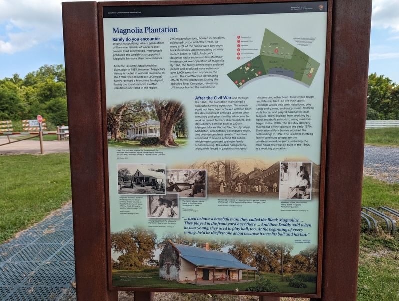
Rarely do you encounter original outbuildings where generations of the same families of workers and owners lived and worked. Here people produced the wealth that supported Magnolia for more than two centuries. Ambrose LeComte established the plantation in 1835. However, Magnolia's history is rooted in colonial Louisiana. In the 1750s, the LeComte (or LeCompte) family received a French-era land grant, laying the foundation for a cotton plantation unrivaled in the region. Likely first built as a hospital for the enslaved, the structure was inhabited by the Planter family following 275 enslaved persons, housed in 70 cabins, cultivated cotton and other crops. As many as 24 of the cabins were two-room brick structures, accommodating a family in each room. In 1852, Ambrose's daughter Atala and son-in-law Matthew Hertzog took over operation of Magnolia. By 1860, the family owned more enslaved people and produced more cotton on over 6,000 acres, then anyone in the parish. The Civil War had devastating effects for the plantation. During the 1864 Red River Campaign, retreating U.S. troops burned the main house.
After the Civil War and through the 1960s, the plantation maintained a successful farming operation. This success could not have been achieved without both the descendants of enslaved workers who remained and other families who came to work as tenant farmers, sharecroppers, and day laborers. Families such as LaCour, Metoyer, Moran, Rachal, Vercher, Cyriaque, Middleton, and Anthony contributed much, and their descendants remain. Their lives continued to revolve around the cabins, which were converted to single-family tenant housing. The cabins had gardens, along with fenced in yards that enclosed chickens and other fowl. Times were tough and life was hard. To lift their spirits residents would visit with neighbors, play cards and games, and enjoy music. Children rode horses and played baseball in local leagues. The transition from working by! hand and draft animals to using machines began in the 1930s. The last day laborers moved out of the cabins in the early 1970s. The National Park Service acquired the outbuildings in 1997. The LeComte-Hertzog family continues to operate the privately-owned property, including the main house that was re-built in the 1890s, as a working plantation.
... used to have a baseball team they called the Black Magnolias... They played in the front yard over there... And then Daddy said when he was young, they used to play ball, too. At the beginning of every inning, he'd be the first one at bat because it was his ball and his bat."
Ambrose J. Hertzog III Oral History Interview
Erected by National Park Service.
Topics. This historical marker is listed in these topic lists: Landmarks • Settlements & Settlers.
Location. 31° 32.991′ N, 92° 56.496′ W. Marker is in Derry, Louisiana, in Natchitoches Parish. Marker is on Highway 119, one mile State Highway 1, on the right when traveling north. Touch for map. Marker is in this post office area: Cloutierville LA 71416, United States of America. Touch for directions.
Other nearby markers. At least 8 other markers are within walking distance of this marker. Oakland Plantation (here, next to this marker); The Sound of Time (within shouting distance of this marker); Magnolia Plantation Site Map (within shouting distance of this marker); Cash or Credit (within shouting distance of this marker); Farming Transitions (within shouting distance of this marker); Plantation Landscape (about 300 feet away, measured in a direct line); Changing Residents (about 300 feet away); Livestock (about 300 feet away). Touch for a list and map of all markers in Derry.
Credits. This page was last revised on July 3, 2023. It was originally submitted on July 3, 2023, by Cajun Scrambler of Assumption, Louisiana. This page has been viewed 74 times since then and 20 times this year. Photos: 1, 2. submitted on July 3, 2023, by Cajun Scrambler of Assumption, Louisiana.

