Derry in Natchitoches Parish, Louisiana — The American South (West South Central)
Plantation Landscape
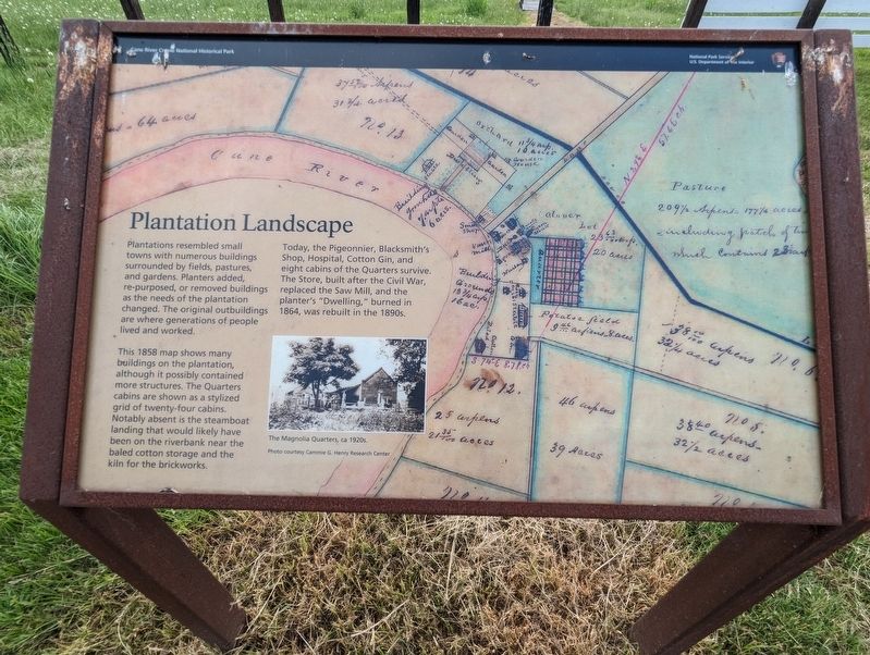
Plantations resembled small towns with numerous buildings surrounded by fields, pastures, and gardens. Planters added, re-purposed, or removed buildings as the needs of the plantation changed. The original outbuildings are where generations of people lived and worked.
This 1858 map shows many buildings on the plantation, although it possibly contained more structures. The Quarters cabins are shown as a stylized grid of twenty-four cabins. Notably absent is the steamboat landing that would likely have been on the riverbank near the baled cotton storage and the kiln for the brickworks.
Today, the Pigeonnier, Blacksmith's Shop, Hospital, Cotton Gin, and eight cabins of the Quarters survive. The Store, built after the Civil War, replaced the Saw Mill, and the planter's "Dwelling," burned in 1864, was rebuilt in the 1890s.
Erected by National Park Service.
Topics. This historical marker is listed in this topic list: Settlements & Settlers.
Location. 31° 32.944′ N, 92° 56.486′ W. Marker is in Derry, Louisiana, in Natchitoches Parish. Marker is on State Highway 119, one mile north of State Highway 1, on the right when traveling north. Touch for map. Marker is at or near this postal address: 5574-5924 LA-119, Cloutierville LA 71416, United States of America. Touch for directions.
Other nearby markers. At least 8 other markers are within walking distance of this marker. A River Runs Through It (within shouting distance of this marker); Magnolia Plantation (about 300 feet away, measured in a direct line); Oakland Plantation (about 300 feet away); Gardens and Porches (about 300 feet away); The Sound of Time (about 400 feet away); Escaped! Freedom Seekers in 1863 (about 400 feet away); Escaped! Freedom Seekers in 1804 (about 400 feet away); Magnolia Plantation Site Map (about 400 feet away). Touch for a list and map of all markers in Derry.
Credits. This page was last revised on July 9, 2023. It was originally submitted on July 9, 2023, by Cajun Scrambler of Assumption, Louisiana. This page has been viewed 57 times since then and 11 times this year. Photos: 1, 2. submitted on July 9, 2023, by Cajun Scrambler of Assumption, Louisiana.

