Bristol in Sullivan County, Tennessee — The American South (East South Central)
First Ironworks
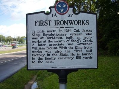
Photographed by Stanley and Terrie Howard, September 27, 2009
1. First Ironworks Marker
Erected by Tennessee Historical Commission. (Marker Number 1A 37.)
Topics and series. This historical marker is listed in these topic lists: Settlements & Settlers • War, US Revolutionary. In addition, it is included in the Tennessee Historical Commission series list. A significant historical year for this entry is 1784.
Location. 36° 32.848′ N, 82° 13.615′ W. Marker is in Bristol, Tennessee, in Sullivan County. It is on Volunteer Parkway (U.S. 11E), on the right when traveling east. Touch for map. Marker is in this post office area: Bristol TN 37620, United States of America. Touch for directions.

Regionally, this marker is in East Tennessee and in the Tri-Cities Area. It is also in the American South, specifically in the Upper South, in Appalachia, and specifically in Southern Appalachia. Globally,
this page online
Other nearby markers. At least 8 other markers are within 3 miles of this marker, measured as the crow flies: King College (approx. 0.2 miles away); Steel-Seneker Houses (approx. 2.3 miles away); Alan Kulwicki (approx. 2.8 miles away); The Allison Family (approx. 2.8 miles away); Dale Earnhardt (approx. 2.9 miles away); Richard Petty (approx. 2.9 miles away); Cale Yarborough (approx. 2.9 miles away); David Pearson (approx. 2.9 miles away). Touch for a list and map of all markers in Bristol.
Credits. This page was last revised on June 16, 2016. It was originally submitted on October 1, 2009, by Stanley and Terrie Howard of Greer, South Carolina. This page has been viewed 1,281 times since then and 39 times this year. Photo 1. submitted on October 1, 2009, by Stanley and Terrie Howard of Greer, South Carolina. • Kevin W. was the editor who published this page.
Editor’s want-list for this marker. Picture of grave marker and family cemetery mentioned on the marker. • Can you help?
