Cochranton in Crawford County, Pennsylvania — The American Northeast (Mid-Atlantic)
French Creek
Shaping Life in Cochranton
Photographed by Mike Wintermantel, September 2, 2023
1. French Creek Marker
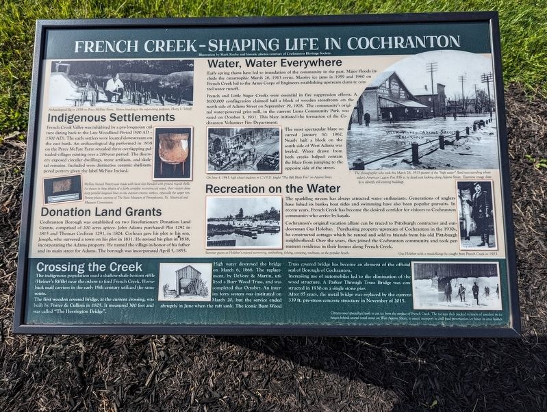
French Creek Valley was inhabited by a pre-Iroquoian culture dating back to the Late Woodland Period (500 AD-1500 AD). The early settlers were located downstream on the east bank. An archaeological dig performed in 1938 on the Perry McFate Farm revealed three overlapping palisaded villages existing over a 200-year period. The discovery exposed circular dwellings, stone artifacts, and skeletal remains. Included were distinctive ceramic shell-tempered pottery given the label McFate Incised.
Donation Land Grants
Cochranton Borough was established on two Revolutionary Donation Land Grants, comprised of 200 acres apiece. John Adams purchased Plot 1292 in 1815 and Thomas Cochran 1291, in 1824. Cochran gave his plot to his son, Joseph, who surveyed a town on his plot in 1831. He revised his plan in 1838, incorporating the Adams property. He named the village in honor of his father and its main street for Adams. The borough was incorporated April 5, 1855.
Water, Water Everywhere
Early spring thaws have led to inundation of the community in the past. Major floods include the catastrophic March 26, 1913
this page online
French and Linde Sugar Creeks were essential in fire suppression efforts. A $100,000 conflagration claimed half a block of wooden storefronts on the north side of Adams Street on September 19, 1928. The community's original water-powered grist mill, in the current Lions Community Park, was razed on October 3, 1931. This blaze initiated the formation of the Cochranton Volunteer Fire Department.
The most spectacular blaze occurred January 30, 1962. Nearly half a block on the south side of West Adam was leveled. Water drawn from both creeks helped contain the blaze from jumping to the opposite side of the street.
Recreation on the Water
The sparkling stream has always attracted water enthusiasts. Generations of anglers have fished its banks, boat rides and swimming have also been popular pursuits. In recent wars, French Creek has become the desired corridor for visitors to Cochranton community who arrive by kayak.
Cochranton's original vacation allure can be traced to Pittsburgh contractor
Photographed by Mike Wintermantel, September 2, 2023
2. French Creek Marker
Crossing the Creek
The indigenous population used a shallow-shale bottom riffle (Heiner's Riffle) near the oxbow to ford French Creek. Horseback mail carriers in the early 19th century utilized the same route.
The first wooden covered bridge, at the current crossing, was built by Porter & Cullom in 1825. It measured 300 feet and abruptly in June when the raft sank. The iconic Bure Wood was called "The Herrington Bridge".
High water destroyed the bridge on March 6, 1868. The replacement, by DeVore & Martin, utilized a Burr Wood Truss, and was completed that October. An interim ferry system was instituted on March 20, but the service ended abruptly in June when the raft sank. The iconic Burr Wood Truss covered bridge has become an element of the official seal of Borough of Cochranton.
Increasing use of automobiles led to the elimination of the wood structure. A Parker Through Truss Bridge was constructed in 1930 on a single stone pier.
After 85 years, the metal bridge was replaced by the current 339 ft. pre-stress concrete structure in November of 2015.
Topics. This historical marker is listed in these topic lists: Bridges & Viaducts • Disasters • Settlements & Settlers. A significant historical date for this entry is January 30, 1962.
Location. 41° 31.122′ N, 80° 3.21′ W. Marker is in Cochranton, Pennsylvania, in Crawford County. It can be reached from Adams Street (Pennsylvania Route 173) west of West Street, on the right when traveling west. Located at Cochranton Landing. Touch for map. Marker is in this post office area: Cochranton PA 16314, United States of America. Touch for directions.

Regionally, this marker is in Northwestern Pennsylvania and in Greater Erie. It is also in the American Northeast, in the Mid-Atlantic, in Appalachia, and specifically in Northern Appalachia. Globally, it is in North America, the Western Hemisphere, the Western World, and the Anglosphere. Historically, it finds itself in what was once the Haudenosaunee (Iroquois) Confederacy and also one of the original Thirteen Colonies.
Other nearby markers. At least 8 other markers are within 8 miles of this marker, measured as the crow flies: George Washington Actually Slept Near Here! (here, next to this marker); Cochranton Boat Launch (here, next to this marker); a different marker also named French Creek (a few steps from this marker); McFate Archaeological Site (a few steps from this marker); Carlton Bridge (approx. 3.7 miles away); a different marker also named French Creek (approx. 3.9 miles away); French Creek Feeder (approx. 5.6 miles away); a different marker also named French Creek Feeder (approx. 7.3 miles away). Touch for a list and map of all markers in Cochranton.
Credits. This page was last revised on September 5, 2023. It was originally submitted on September 5, 2023, by Mike Wintermantel of Pittsburgh, Pennsylvania. This page has been viewed 688 times since then and 77 times this year. Photos: 1, 2. submitted on September 5, 2023, by Mike Wintermantel of Pittsburgh, Pennsylvania.
