Montjuïc in Barcelona, Catalonia, Spain — Southwestern Europe (Iberian Peninsula)
El segon recinte / The outer ward
El segundo recinto / La deuxième enceinte
El segon recinte
Després de la reforma de Juan Martín Cermeño entre 1753 i 1779, Montjuïc disposava de dues plataformes: la superior, orientada a la ciutat, que contenia les principals dependències i habitacles del Castell, i la inferior, orientada al mar i al riu Llobregat, que contenia tot un sistema d'estructures defensives destinades a protegir el Castell en cas de setge pel costat meridional.
El glacis interior [1], més enllà del revelli, és un terraplè atalussat ascendent que servia per deixar al descobert les tropes assaltants que ja haguessin penetrat en el segon recinte, de manera que poguessin ser abatudes amb facilitat des de la plataforma superior. Aquest glacis estava flanquejat per un cami cobert [2], és a dir, un espai protegit per un parapet que permetia que les tropes del Castell defensessin l'accés al fossat. Al fons d'aquest glacis hi havia una gran bassa que recollia aigües pluvials del pendent i dels baluards.
El baluard de Velasco [3], orientat vers la vall del Llobregat i el pla de Barcelona, és l'estructura defensiva més gran del Castell i també servia per acollir morters i peces d'artilleria en les seves nombroses troneres.
El baluard de la Llengua de Serp [4], de planta gairebé triangular, era el sector més dèbil del Castell en el moment de la reforma barroca, motiu pel qual s'hi afegiren la lluneta de mar [5] i la lluneta de terra [6], dues estructures que contribuïren a la forma viperina que dóna nom al baluard. La lluneta de mar, de forma irregular, contenia dependències per a una petita guarnició i s'erigí com una defensa avançada del baluard. Per la seva banda, la lluneta de terra, de planta pentagonal, també allotjava una guarnició i un polvorí.
El segundo recinto
Después de la reforma de Juan Martín Cermeño entre 1753 y 1779, Montjuic disponía de dos plataformas: la superior, orientada a la ciudad, que contenia las principales dependencias y habitáculos del Castillo, y la inferior, orientada al mar y al río Llobregat, que contenía todo un sistema de estructuras defensivas destinadas a proteger el Castillo en caso de ataque por el flanco meridional.
El glacis interior [1], más allá del revellín, es un terraplén ataludado ascendente que servía para dejar al descubierto las tropas asaltantes que ya hubiesen penetrado en el segundo recinto, de manera que pudieran ser abatidas con facilidad desde la plataforma superior. Este glacis estaba franqueado por un camino cubierto [2], es decir, por un espacio protegido por un parapeto que permitía a las tropas del Castillo defender el acceso al foso. Al fondo de este glacis había una gran balsa que recogía las aguas pluviales de la pendiente y los baluartes.
El baluarte de Velasco [3], orientado hacia el valle del Llobregat y el llano de Barcelona, es la estructura defensiva más grande del Castillo y también servía para acoger morteros y piezas de artillería en sus numerosas troneras.
El baluarte de la Llengua de Serp [4], de planta casi triangular, era el sector más débil del Castillo en el momento de la reforma barroca, motivo por el que se añadieron la luneta de mar [5] y la luneta de tierra [6], dos estructuras que contribuyeron a la forma viperina que da nombre al baluarte. La luneta de mar, de forma irregular, contenía dependencias para una pequeña guarnición y se erigió como una defensa avanzada del baluarte. Por su parte, la luneta de tierra, de planta pentagonal, también alojaba una guarnición y un polvorín.
The outer ward
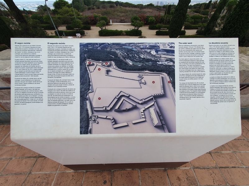
After the modifications introduced by Juan Martin Cermeño between 1753 and 1779, Montjuïc had two wards or platforms: the upper, inner one, facing the city, and containing the main quarters and facilities; and the lower, outer one oriented
toward
the sea and the River Llobregat, containing a system
of defensive structures that served to protect the
Castle in case of attack from the southern side.
The interior glacis [1], beyond the ravelin, is an inclined embankment designed to leave exposed any assailants who had already breached the outer ward, so that they could easily be attacked from the upper platform. This glacis was flanked by a covered way [2], a corridor protected by a parapet from where troops could defend the Castle moat. At the foot of this glacis there was a large pond for collecting rainwater from the talus and the bastions.
The Velasco Bastion [3], oriented towards the valley of the River Llobregat and the plain of Barcelona, is the largest defensive structure in the Castle and housed mortars and artillery pieces in its many embrasures.
The Llengua de Serp Bastion [4], with an almost triangular layout, was the weakest part of the Castle before the Baroque reform, which is why seaward and landward lunettes were added, two outworks that contribute to the snake's tongue shape that gives the bastion its name. The irregularly shaped seaward lunette [5] had accommodation for a small garrison and served as an advanced defence beyond the bastion. The landward lunette [6], presenting a pentagonal layout, also housed a garrison and a gunpowder magazine.
La deuxième enceinte
Depuis la rénovation de Juan Martín Cermeño entre 1753 y 1779, Montjuic disposait de deux plates-formes: celle supérieure, orientée vers la ville et contenait les principales dépendances et les logements du Château; et celle inférieure orientée vers la mer et la rivière Llobregat qui contenait tout un système de structures défensives destinées à protéger le Château en cas d'attaque par le côté sud.
Le glacis intérieur [1], au-delà du ravelin, est un remblai ascendant qui servait à exposer les troupes assaillantes qui aurait pénétré dans la seconde enceinte, de manière à ce qu'elles puissent être abattues avec facilité depuis la plate-forme supérieure. Ce glacis était traversé par un chemin couvert [2], c'est-à-dire, un espace protégé par un parapet qui permettait que les troupes du Château défendirent l'accès au fossé. Au fond de ce glacis il y avait un grand bassin qui récupérait les eaux pluviales de la pente et des bastions.
Le bastion de Velasco [3], orienté vers la vallée du Llobregat et la plaine de Barcelone, est la structure défensive la plus grande du Château et servait aussi pour accueillir les mortiers et pièces d'artillerie dans ses nombreuses meurtrières.
Le bastion de la Llengua de Serp [4], de forme presque triangulaire, était le secteur le plus faible du Château au moment de la rénovation baroque, raison pour laquelle furent ajoutées la lunette de mer [5] et la lunette de terre [6], deux structures qui contribuèrent à la forme de serpent qui donne son nom au Bastion. La lunette de mer, de forme irrégulière, contenait les dépendances pour une petite garnison et s'érigeait comme un bastion de défense avancée. De son côté, la lunette de terre, de forme pentagonale, abritait aussi une garnison et une poudrière.
Topics. This historical marker is listed in this topic list: Forts and Castles. A significant historical year for this entry is 1753.
Location. 41° 21.78′ N, 2° 9.958′ E. Marker is in Barcelona, Cataluña (Catalonia). It is in Montjuïc. Marker can be reached from Carretera de Montjuïc. The marker is at the Montjuic Castle, on the second level terrace to the left side of the southernmost corner. Touch for map. Marker is at or near this postal address: Ctra de Montjuïc 66, Barcelona, Cataluña 08038, Spain. Touch for directions.
Other nearby markers. At least 8 other markers are within walking distance of this marker. L'antic fortí / The early fort (a few steps from this marker); Els calabossos del Castell / The Castle Dungeons / Los Calabozos del Castillo (within shouting distance of this marker); El pati d’armes o quadrat / The parade ground or courtyard (within shouting distance of this marker); El juidici del President Lluís Companys / The Trial of President Lluís Companys (within shouting distance of this marker); La torre de guaita / The Watchtower / La torre vigia / La tour de guet (about 90 meters away, measured in a direct line); Méchain Etablí les Coordenades de Barcelona / Méchain Establishes the Coordinates of Barcelona (about 90 meters away); Gaspar de Portolà (about 120 meters away); El baluard de Sant Carles / The Sant Carles Bastion / El baluarte de Sant Carles (about 120 meters away). Touch for a list and map of all markers in Barcelona.
Credits. This page was last revised on September 7, 2023. It was originally submitted on September 7, 2023, by J. Makali Bruton of Accra, Ghana. This page has been viewed 49 times since then and 13 times this year. Photos: 1, 2, 3. submitted on September 7, 2023, by J. Makali Bruton of Accra, Ghana.


