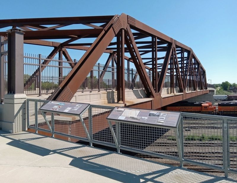
Marshall Terrace in Minneapolis in Hennepin County, Minnesota — The American Midwest (Upper Plains)
New Bridge Planning Process and Design
Community Design Process
In 1911, a four-span Howe truss bridge became the first of three to carry passenger traffic across the Northtown Yards. In 1925, it was replaced with a wider five-span Warren truss bridge. This bridge—then part of St. Anthony Boulevard and now known as the St. Anthony Parkway Bridge—served as part of the city's Grand Rounds for 90 years. Well past its design life of 50 years, the decision to replaced the well-loved historic structure at the gateway to Columbia Park involved years of planning and community input.
In 2008 the City of Minneapolis formally announced plans to replaced the bridge. At the same time, the City convened a Community Advisory Committee (CAC) comprised of businesses and residents in the Columbia Park and Marshall Terrace neighborhoods. Other community stakeholders included the Minneapolis Park & Recreation Board, Metro Transit, and the BNSF Railroad.
The CAC and the design team studied the unique challenges of building over an active rail yard. The Federal Section 106 Process required that additional rehabilitation studies be conducted, including determination of historical significance. The Minnesota Department of Transportation's Cultural Resources Unit, Federal Highway Administration, State Historic Preservation Office, and City of Minneapolis participated in the historic resource evaluation. In 2013, a public open house was held to discuss the historic bridge, mitigation opportunities, and bridge type selection.
The City hired the SEH/Parsons team to provide preliminary and final plans for a new bridge. The CAC was re-engaged for the design process including new members representing the Holland neighborhood. The Warren truss option, with its innovative load path and redundant through-truss, was selected as the best design. Through final ribbon cutting, the CAC continued to provide community insight and support.
Designing the Bridge
The new St. Anthony Parkway Bridge consists of a 305-foot steel Warren truss main span and two 127-foot steel beam eastern approach spans, crossing the Northtown Yards with a unique "redundant" structural system. Truss bridges are traditionally non-redundant structures, having only two planes of main load-carrying elements. Several truss members carry tension forces: bottom chords, diagonals and verticals. These tension members, as typically constructed, are considered "fracture critical", that is, where the loss of any single member would likely result in the collapse of the structure. A truss bridge can be made non-fracture critical through the use of duplicate components or redundancy.
Truss members of the St. Anthony Parkway Bridge were made redundant through
split diagonal and vertical tension members, and post-tensioned bottom chord members. The top chord connection was made redundant through the use of dual plates connecting the flanges of diagonal members to the flanges of the top chord members. The top chord and diagonals consist of H and T sections of the same overall width. This allows the connection plates to be in the same plane as the H-section flanges, thus creating load path continuity from flanges to connection plates and back to flanges.
Removal and Launching
Engineers used a unique construction approach to dismantle the old bridge and construct a new one over an active railroad corridor. The three eastern spans of the bridge were removed in pieces with cranes. After temporary support beams were in position, the two old western spans were removed as whole truss spans. A new bridge pier was constructed in the middle of the rail yard, and the new truss was rolled into position using the same temporary support beams, minimizing impacts to the main line tracks.
Historic Bridge Recordation
The St. Anthony Parkway Bridge was determined to be eligible for listing on the National Register of Historic Places and is part of the Grand Rounds Scenic Byway. Prior to demolition, it was recorded for the Historic American Engineering Record (HAER), with documentation of its history and structural design.
St. Anthony Parkway Bridge in ca. 1950.
Elevation of the new bridge as designed, SEH/Parsons, 2013.
Cross section of the new bridge, SEH/Parsons, 2013.
Rendering of the new bridge, Touchstone Architecture, 2013.
Top chord connection.
Top chord connections.
Bottom chord connections.
Removing the old trusses.
Launching the new truss.
The St. Anthony Parkway bridge under construction in 1925.
The bridge in 2014. (D. Pratt, HAER)
Topics. This historical marker is listed in these topic lists: Bridges & Viaducts • Railroads & Streetcars. A significant historical year for this entry is 2008.
Location. 45° 1.65′ N, 93° 16.139′ W. Marker is in Minneapolis, Minnesota, in Hennepin County. It is in Marshall Terrace. Marker is at the intersection of St. Anthony Parkway and California Street NE, on the right when traveling east on St. Anthony Parkway. The marker is at the Northtown Railyard Overlook. Touch for map. Marker is in this post office area: Minneapolis MN 55418, United States of America. Touch for directions.
Other nearby markers. At least 8 other markers are within one mile of this marker, measured as the crow flies. Northtown and the St. Anthony Parkway Bridge (here, next to this marker); Columbia Park and Golf Course (here, next to this marker); Park Planning and the Grand Rounds (here, next to this marker); Prairie to Brickyard: The Landscape of Northtown (a few steps from this marker); Carl Ripken, Sr. (approx. ¼ mile away); MLB ★ Minnesota Twins Rod Carew All★Star Field (approx. ¼ mile away); Marshall Terrace (approx. 0.3 miles away); Land Use (approx. one mile away). Touch for a list and map of all markers in Minneapolis.
Credits. This page was last revised on September 9, 2023. It was originally submitted on September 8, 2023, by McGhiever of Minneapolis, Minnesota. This page has been viewed 49 times since then and 12 times this year. Photos: 1, 2. submitted on September 8, 2023, by McGhiever of Minneapolis, Minnesota. • J. Makali Bruton was the editor who published this page.

