Near Oak Park Heights in Washington County, Minnesota — The American Midwest (Upper Plains)
St. Croix Crossing
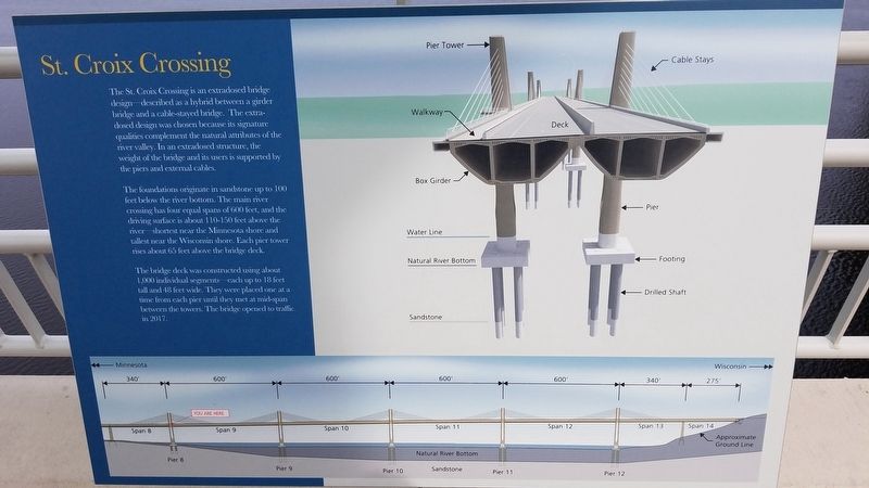
The foundations originate in sandstone up to 100 feet below the river bottom. The main river crossing has four equal spans of 600 feet, and the driving surface is about 110-150 feet above the river—shortest near the Minnesota shore and tallest near the Wisconsin shore. Each pier tower rises about 65 feet above the bridge deck.
The bridge deck was constructed using about 1,000 individual segments—each up to 18 feet tall and 48 feet wide. They were placed one at a time from each pier until they met at mid-span between the towers. The bridge opened to traffic in 2017.
Erected 2017.
Topics. This historical marker is listed in this topic list: Bridges & Viaducts.
Location. 45° 2.369′ N, 92° 47.25′ W. Marker is near Oak Park Heights, Minnesota, in Washington County. Marker is on Minnesota Route 36, on the right when traveling west . It is located along the St. Croix Trail Crossing Loop path. Touch for map. Marker is in this post office area: Stillwater MN 55082, United States of America. Touch for directions.
Other nearby markers. At least 8 other markers are within walking distance of this marker. Building a Bridge (a few steps from this marker); Where's the State Boundary? (approx. 0.2 miles away); Steamboats on the St. Croix (approx. ¼ mile away); White Pine Treaty (approx. ¼ mile away in Wisconsin); Lake St. Croix (approx. 0.4 miles away); Lake St. Croix Overlook (approx. 0.4 miles away); Migration (approx. half a mile away in Wisconsin); Protecting the Watershed (approx. half a mile away in Wisconsin). Touch for a list and map of all markers in Oak Park Heights.
Credits. This page was last revised on September 26, 2023. It was originally submitted on April 13, 2020, by Fitzie Heimdahl of Eau Claire, Wisconsin. This page has been viewed 138 times since then and 11 times this year. Last updated on September 25, 2023, by McGhiever of Minneapolis, Minnesota. Photos: 1. submitted on April 13, 2020, by Fitzie Heimdahl of Eau Claire, Wisconsin. 2. submitted on September 25, 2023, by McGhiever of Minneapolis, Minnesota. • J. Makali Bruton was the editor who published this page.

