Shippensburg in Cumberland County, Pennsylvania — The American Northeast (Mid-Atlantic)
Railroad Signaling
Cumberland Valley Railroad Museum
— Cumberland Valley Rails-to-Trails —
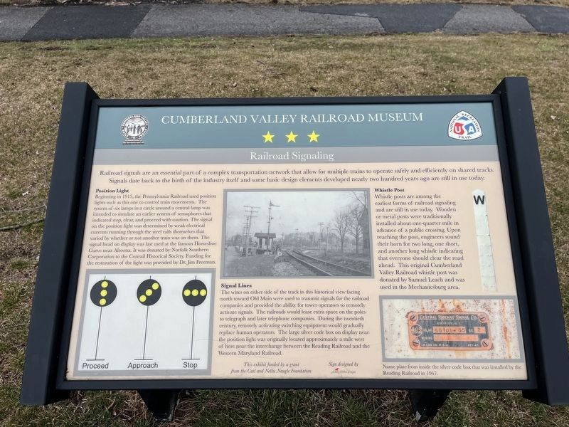
Railroad signals are an essential part of a complex transportation network that allow for multiple trains to operate safely and efficiently on shared tracks. Signals date back to the birth of the industry itself and some basic design elements developed nearly two hundred years ago are still in use today.
Position Light
Beginning in 1915, the Pennsylvania Railroad used position lights such as this one to control train movements. The system of six lamps in a circle around a central lamp was intended to simulate an earlier system of semaphores that indicate stop, clear, and proceed with caution. The signal on the position light was determined by weak electrical currents running through the steel rails themselves that varied by whether or not another train was on them. The signal ahead on display was used at the famous Horseshoe Curve near Altoona. It was donated by Norfolk Southern Corporation to the Conrail Historical Society. Funding for the restoration of the light was provided by Dr. Jim Freeman.
Signal Lines
The wires on either side of the track in this historical view facing north toward Old Main were used to transmit signals for the railroad companies and provided the ability for tower operators to remotely activate signals. The railroads would lease extra space on the poles to telegraph and later telephone companies. During the twentieth century, remotely activating switching equipment would gradually replace human operators. The large silver code box on display near the position light was originally located approximately a mile west of here near the interchange between the Reading Railroad and the Western Maryland Railroad.
Whistle Post
Whistle posts are among the earliest forms of railroad signaling and are still in use today. Wooden or metal posts were traditionally installed about one-quarter mile in advance of a public crossing. Upon reaching the post, engineers sound their horn for two long, one short, and another long whistle indicating that everyone should clear the road ahead. This original Cumberland Valley Railroad whistle post was donated by Samuel Leach and was used in the Mechanicsburg area.
Topics and series. This historical marker is listed in these topic lists: Communications • Industry & Commerce • Railroads & Streetcars. In addition, it is included in the Pennsylvania Railroad (PRR) series list. A significant historical year for this entry is 1915.
Location. 40° 3.243′ N, 77° 31.317′ W. Marker is in Shippensburg, Pennsylvania, in Cumberland County. Marker is on Cumberland Valley Rail Trail north of West Fort Street, on the left when traveling north. Touch for map
Other nearby markers. At least 8 other markers are within walking distance of this marker. Penn Central Boxcar (a few steps from this marker); Experience the Cumberland Valley Rail Trail (within shouting distance of this marker); Conrail Boxcar (within shouting distance of this marker); One-Room Schoolhouse (about 300 feet away, measured in a direct line); B&O Coal Hopper (about 500 feet away); "On This Site" (approx. 0.2 miles away); Delivering An Education (approx. ¼ mile away); Lifeline of the Valley: The Cumberland Valley Railroad (approx. ¼ mile away). Touch for a list and map of all markers in Shippensburg.
Credits. This page was last revised on March 1, 2024. It was originally submitted on March 1, 2024, by Devry Becker Jones of Washington, District of Columbia. This page has been viewed 52 times since then. Photos: 1, 2. submitted on March 1, 2024, by Devry Becker Jones of Washington, District of Columbia.

