Lansing in Fayette County, West Virginia — The American South (Appalachia)
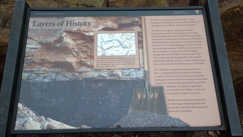
Layers of History
New River Gorge National Park and Preserve
New River coal, the natural resource that created the gorge's boom and bust economy, is the product of a geologic process millions of years in the making.
300 million years ago, the landscape here was a tropical swamp covered with vegetation. Over time, continental uplift and erosion covered decayed plants and animals. Pressure from overlying layers of sediment transformed these peat bogs into coal buried beneath layers of rock. Generally speaking, every foot of coal represents approximately 10,000 years of continuous peat accumulation. Coal seams in West Virginia average three feet tall. Waters of the ancestral Teays River, today's New River, gradually cut through the Appalachian plateau, carving a corridor and exposing the seam of coal and other rocks you see in the gorge.
The "smokeless" bituminous coal from the New River coalfields helped fuel America's industrial revolution. The life cycle of coal does not end with mining, however, but with the burning of coal and the return of its carbon to the atmosphere as fossil fuel emissions. A complicated geological process that took millions of years can be burned in a matter of minutes.
Will the environmental consequences of extracting and burning fossil fuels exceed the economic and energy gains we receive from them?
(caption) The ancient Teays River was blocked when the most recent glacial front came through around 24,000 years ago. When the glaciers receded around 14,000 years ago, it revealed the New River flowing in what was the former Teays riverbed.
Erected by National Park Service US. Department of the Interior.
Topics. This historical marker is listed in these topic lists: Natural Resources • Paleontology.
Location. 38° 4.19′ N, 81° 4.713′ W. Marker is in Lansing, West Virginia, in Fayette County. Marker is on U.S. Highway 19, on the left when traveling east. Touch for map. Marker is at or near this postal address: 52 US Hwy 19, Fayetteville WV 25840, United States of America. Touch for directions.
Other nearby markers. At least 8 other markers are within walking distance of this marker. Growth of an Era (a few steps from this marker); The Bridge (within shouting distance of this marker); Spanning the Gorge (within shouting distance of this marker); a different marker also named The Bridge (about 300 feet away, measured in a direct line); From Coal Mining to Rock Climbing (about 500 feet away); New River Gorge Bridge (about 600 feet away); Smoke, Coke, Coal, and Kaymoor (about 700 feet away); New River Gorge Scenic Drives (about 700 feet away). Touch for a list and map of all markers in Lansing.
Credits. This page was last revised on March 10, 2024. It was originally submitted on March 6, 2024, by Craig Doda of Napoleon, Ohio. This page has been viewed 37 times since then. Photos: 1, 2. submitted on March 6, 2024, by Craig Doda of Napoleon, Ohio. • Andrew Ruppenstein was the editor who published this page.

