Mount Hope in Fayette County, West Virginia — The American South (Appalachia)
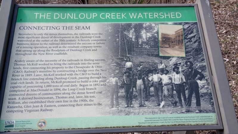
Connecting The Seam
The Dunloup Creek Watershed
Secondary to only the mines themselves, the railroads were the most significant driver of development in the Dunloup Creek watershed at the outset of the 20th century. A fiercely competitive business, access to the railroad determined the success or failure of a mining operation, as well as the resultant company towns that sprang up along the floodplain of Dunloup Creek and throughout the New River coalfields.
Acutely aware of the necessity of the railroads in finding success, Thomas McKell worked to bring the railroads into the mine lands, first connecting his property to the Chesapeake & Ohio (C&O) Railway's mainline by constructing a bridge over the New River in 1889. Later, McKell worked with the C&O to build a branch line extending along Dunloup Creek, passing through his coal-rich lands. In return, McKell promised to build a coke plant capable of processing 1,000 tons of coal daily. Begun in 1892 and completed at MacDonald in 1894, the Loop Creek branch connected dozens of communities along the dense Sewell coal seam. A shrewd businessman, Thomas and, later, his son, William, also established their own line in the 1900s, the Kanawha, Glen Jean & Eastern, connecting their mines to the competing Virginian Railway.
Erected by Natural Resources Conservation Service, U.S. Department of Agriculture.
Topics. This historical marker is listed in these topic lists: Industry & Commerce • Natural Resources • Settlements & Settlers. A significant historical year for this entry is 1889.
Location. 37° 53.932′ N, 81° 9.478′ W. Marker is in Mount Hope, West Virginia, in Fayette County. Marker is on Main Street (West Virginia Route 211) 0.1 miles south of Evans Hill Road (County Road 21/12), on the right when traveling north. Touch for map. Marker is at or near this postal address: 71 Main St, Mount Hope WV 25880, United States of America. Touch for directions.
Other nearby markers. At least 8 other markers are within walking distance of this marker. The Arrival Of Coal Towns (here, next to this marker); Mount Hope School History (within shouting distance of this marker); Mount Hope Landmarks (within shouting distance of this marker); Mount Hope Early Town History (within shouting distance of this marker); Mount Hope Coal History (within shouting distance of this marker); Dubois School History (within shouting distance of this marker); Dubois High School (about 400 feet away, measured in a direct line); DuBois High School (about 600 feet away). Touch for a list and map of all markers in Mount Hope.
Credits. This page was last revised on March 15, 2024. It was originally submitted on March 8, 2024, by Craig Doda of Napoleon, Ohio. This page has been viewed 27 times since then. Photos: 1, 2. submitted on March 8, 2024, by Craig Doda of Napoleon, Ohio. • Devry Becker Jones was the editor who published this page.

