Mount Hope in Fayette County, West Virginia — The American South (Appalachia)
Phoenix City of the New River
Mt. Hope
— Coal Heritage Trail —
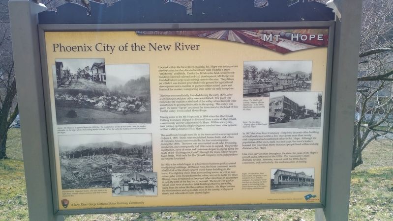
Located within the New River coalfield, Mt. Hope was an important service center for the oldest of southern West Virginia's three "smokeless" coalfields. Unlike the Pocahontas field, where town- building followed railroad and coal development, Mt. Hope was founded before large-scale mining came to the area. The plateau on which it was located provided fertile ground for agricultural development and a number of pioneer settlers raised crops and livestock for market, transporting their cattle via early turnpikes.
The town was unofficially founded during the early 1870s, after a schoolhouse and post office were established. The place was named for its location at the head of the valley where farmers were accustomed to grazing their cattle in the spring. This valley was given the name "Egypt" and since the town stood at the head of this fruitful valley, it was called Mount Hope.
Mining came to the Mt. Hope area in 1894 when the MacDonald Colliery Company shipped its first coal from a mine at MacDonald, a community directly adjacent to Mt. Hope. Within a few years four mining operations employing four hundred men were opened within walking distance of Mt. Hope.
This coal boom brought new life to the town and it was incorporated on June 1, 1895. Stores were established, homes built, and scores of company houses were erected by the four coal companies during the 1890s. The town was surrounded on all sides by mining companies, and consequently had little room to expand. Despite the constriction, rows of stores and businesses began to appear along the route of the "old stagecoach road" through the town, which became Main Street. With only the MacDonald company store, independent merchants flourished.
In 1910, a fire which began in a downtown business quickly spread to adjoining buildings. Within an hour, the blaze consumed nearly a half-block of the closely spaced wood-frame buildings in the town. Fire-fighting crews from surrounding towns, as well as coal miners who were released from the mines, arrived to battle the blaze. Mining crews dynamited a saloon and other structures in an attempt to stop the path of the fire, but to no avail. The town was quickly rebuilt with rows of modern brick buildings that you see today, rising from the ashes like the mythical Phoenix. Mt. Hope became the most modern and up-to-date town in the county, with paved streets and sidewalks lit with electric lights.
In 1917 the New River Company completed its main office building at MacDonald and within a few short years more than twenty coal companies had established offices in Mt. Hope. Although the population of the town, itself, was not large, the town's leaders boasted that more than thirty-thousand people lived within walking distance of Mt. Hope.
Like most service cities throughout the state, the peak of Mt. Hope's growth came at the end of the 1920s. The community's most dramatic decline, however, was not until the 1950s due to a recession, and particularly, the mechanization of mining.
Above: Mt. Hope, as it appeared before the 1910 fire. The inset photo is a view of main street - note the wooden sidewalks. In the larger photo, the building marked with an "X" on the roof is the building where the disastrous fire began.
Downtown Mt. Hope after the fire. The inset photo to the right shows a couple setup to continue with their business despite the fire.
Topics. This historical marker is listed in these topic lists: Industry & Commerce • Natural Resources • Settlements & Settlers. A significant historical date for this entry is June 1, 1895.
Location. 37° 53.442′ N, 81° 10.306′ W. Marker is in Mount Hope, West Virginia, in Fayette County. Marker is on Main Street (West Virginia Route 211) 0.1 miles east of North Michigan Avenue, on the right when traveling north. Touch for map. Marker is at or near this postal address: 267 Main Street, Mount Hope WV 25880, United States of America. Touch for directions.
Other nearby markers. At least 8 other markers are within walking distance of this marker. Mine Safety (here, next to this marker); New River Coalfield (here, next to this marker); The Coming of the Railroads (here, next to this marker); The Coal Companies (here, next to this marker); The Dunloup Creek Watershed (approx. 0.2 miles away); a different marker also named The Dunloup Creek Watershed (approx. 0.2 miles away); a different marker also named The Dunloup Creek Watershed (approx. 0.2 miles away); Siltix Mine Disaster (approx. ¼ mile away). Touch for a list and map of all markers in Mount Hope.
Credits. This page was last revised on March 15, 2024. It was originally submitted on March 8, 2024, by Craig Doda of Napoleon, Ohio. This page has been viewed 28 times since then. Photos: 1, 2, 3. submitted on March 8, 2024, by Craig Doda of Napoleon, Ohio. • Devry Becker Jones was the editor who published this page.


