Mount Vernon in Rockcastle County, Kentucky — The American South (East South Central)
City of Mount Vernon - 1800's
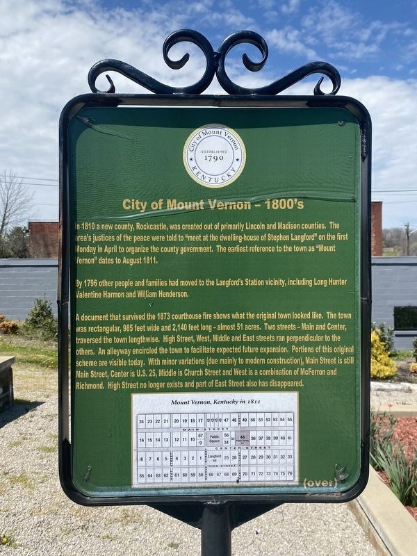
By 1796 other people and families had moved to the Langford's Station vicinity, including Long Hunter Valentine Harmon and William Henderson.
A document that survived the 1873 courthouse fire shows what the original town looked like. The town was rectangular, 985 feet wide and 2,140 feet long - almost 51 acres. Two streets - Main and Center, traversed the town lengthwise. High Street, West, Middle and East streets ran perpendicular to the others. An alleyway encircled the town to facilitate expected future expansion. Portions of this original scheme are visible today. With minor variations (due mainly to modern construction), Main Street is still Main Street, Center is U.S. 25, Middle is Church Street and West is a combination of McFerron and Richmond. High Street no longer exists and part of East Street also has disappeared.
Erected by City of Mount Vernon.
Topics. This historical marker is listed in this topic list: Notable Places.
Location. 37° 21.206′ N, 84° 20.428′ W. Marker is in Mount Vernon, Kentucky, in Rockcastle County. Marker is at the intersection of Richmond Street and West Main Street, on the left when traveling north on Richmond Street. Touch for map. Marker is at or near this postal address: 100 Richmond St, Mount Vernon KY 40456, United States of America. Touch for directions.
Other nearby markers. At least 8 other markers are within walking distance of this marker. Longhunters / George Washington's Deer Park (here, next to this marker); Pioneer Routes In Rockcastle County (here, next to this marker); How the City of Mount Vernon was named (here, next to this marker); Stephen Langford (here, next to this marker); C.C. Williams Home (a few steps from this marker); Fritz Krueger Building (within shouting distance of this marker); Triangle Park (within shouting distance of this marker); a different marker also named Triangle Park (within shouting distance of this marker). Touch for a list and map of all markers in Mount Vernon.
Credits. This page was last revised on April 13, 2024. It was originally submitted on April 8, 2024, by Darren Jefferson Clay of Duluth, Georgia. This page has been viewed 39 times since then. Photos: 1, 2, 3. submitted on April 11, 2024, by Darren Jefferson Clay of Duluth, Georgia. • James Hulse was the editor who published this page.


