Newtown in Western Region, Connecticut — The American Northeast (New England)
Washington – Rochambeau Revolutionary Route
Housatonic Crossing
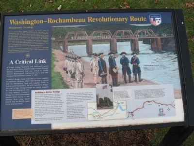
Photographed by Michael Herrick, January 20, 2010
1. Washington – Rochambeau Revolutionary Route Marker
This is one of 10 informative panels that mark the French route south through Connecticut from June 19 to July 2, 1781 and on the return north October 23 to November 9, 1782.
A Critical Link
A bridge linking Newtown and Southbury across the Housatonic River helped create a route through Western Connecticut that was critical to supply General Washington’s Continental Army and later transport Rochambeau’s troops in 1781.
Carleton’s Bridge made it possible to move supplies to and from
this page online
Building a Better Bridge
The first bridge linking Southbury to Newtown was built in 1766 by Thomas Toucey of Woodbury. Each winter, ice and cold took its toll causing constant disrepair. Daily traffic used Hinman’s Ferry and a river ford, which became impassable when the Housatonic swelled. In 1778, Washington ordered his army engineers to build a new bridge.
Carleton’s Bridge was most likely named for the army officer in charge of construction. French officers later marveled at its design. Instead of pillars, log cribs were constructed, filled with stone and sunk into place. The cribs became the supports for the bridge.
Some 4,700 French troops and most of the supply wagons crossed it between June 28 and July 1, 1781. Artillery units with siege cannons were
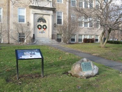
Photographed by Michael Herrick, January 20, 2010
2. Washington – Rochambeau Revolutionary Route Marker
The victorious French Army marched back across on October 24-26, 1782 after helping the Continental Army defeat the British at Yorktown. After crossing into Southbury, the troops made their way to camp at Breakneck Hill in Middlebury.
The location of the flagpole in Newtown marks where the Old Meeting House once stood. The Old Meeting House was a place of worship when the French Army passed through and was marked on French maps. As years passed, Carleton’s Bridge needed constant repairs and Hinman’s Ferry continued to run along side it as an alternative way across the Housatonic River. In 1789, Carleton’s Bridge was replaced by a new structure just north of today’s Interstate 84, which was built by brothers Abel, Isaac and Thomas Bennett, named Bennett’s Bridge. It kept that name into the 20th century. Daily traffic now uses Interstate 84 to cross the Housatonic, but stone abutments from the 18th century bridge are still visible on the Newtown side of the river when the water is low.
Topics and series. This historical marker is listed in these topic lists: Bridges & Viaducts • War, US Revolutionary. In addition, it is included in the Former U.S. Presidents: #01 George Washington, and the The Washington-Rochambeau Route series lists. A significant historical date for this entry is June 19, 1780.
Location. 41° 24.875′ N, 73° 18.138′ W. Marker is in Newtown in Western Region, Connecticut. It is at the intersection of Church Hill Road (U.S. 6) and Queen Street, on the right when traveling west on Church Hill Road. Located in front of Hawley School. Touch for map. Marker is at or near this postal address: 29 Church Hill Road, Newtown CT 06470, United States of America. Touch for directions.

Regionally, this marker is on the Connecticut Shoreline and in Greater Bridgeport. It is also in the American Northeast and in New England. Globally, it is in North America, the Western Hemisphere, the Western World, and the Anglosphere. Historically, it finds itself in what was once Fairfield County and also one of the original Thirteen Colonies.
Other nearby markers. At least 8 other markers are within 4 miles of this marker, measured as the crow flies: In Commemoration (here, next to this marker); Rochambeau (approx. 0.3 miles away); Cyrenius H. Booth Library (approx. 0.4 miles away); Newtown Meeting House (approx. 0.4 miles away); Rev. John Beach, A.M. (approx. 0.4 miles away); Newtown (approx. 0.4 miles away); Newtown Veterans Memorial (approx. half a mile away); Where Rochambeau Crossed the Housatonic River (approx. 3.3 miles away). Touch for a list and map of all markers in Newtown.
Credits. This page was last revised on May 19, 2026. It was originally submitted on January 26, 2010, by Michael Herrick of Southbury, Connecticut. This page has been viewed 4,115 times since then and 132 times this year. Photos: 1, 2. submitted on January 26, 2010, by Michael Herrick of Southbury, Connecticut. • Bill Pfingsten was the editor who published this page.
