The Annex in New Haven in New Haven County, Connecticut — The American Northeast (New England)
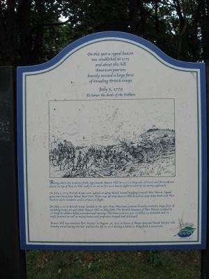
Beacon Hill
was established in 1775
and about this hill
American patriots
bravely resisted a large force
of invading British troops
July 5, 1779
To honor the deeds of the Fathers
On July 4, 1779 British troops were sighted in Long Island Sound heading towards New Haven. Signal guns were fired from Black Rock Fort. A fire was set atop Beacon Hill as well as atop East Rock and West Rock to warn residents and to prepare to fight.
On July 5, 1779 British troops landed on the east shore. American patriots bravely resisted a large force of invading troops on and about Beacon Hill on July fifth. The British invasion of New Haven resulted in 56 English soldiers killed, wounded and missing. The American loss was 23 killed, 15 wounded and 12 made prisoner as well as many homes and properties burned and destroyed.
Beacon Hill was renamed Fort Wooster in August 26, 1814 in honor of Major-General David Wooster who bravely served during the war and lost his life in 1777 during a battle in Ridgefield, Connecticut.
Erected 2001.
Topics. This historical marker is listed in these topic lists: Forts and Castles • War, US Revolutionary. A significant historical month for this entry is July 1779.
Location. 41° 16.946′ N, 72° 53.555′ W. Marker is in New Haven, Connecticut, in New Haven County. It is in The Annex. Marker is at the intersection of Beacon Avenue and Clarendon Street, on the right when traveling south on Beacon Avenue. Located in Fort Wooster Park. Touch for map. Marker is in this post office area: East Haven CT 06512, United States of America. Touch for directions.
Other nearby markers. At least 8 other markers are within one mile of this marker, measured as the crow flies. A Quinnipiac Indian (about 400 feet away, measured in a direct line); Fort Wooster Park (about 400 feet away); East Shore Park (approx. half a mile away); 32nd Ward World War I Memorial (approx. 0.8 miles away); Fort Nathan Hale (approx. one mile away); In Honor of Captain Nathan Hale (approx. one mile away); The Oyster Industry in New Haven (approx. one mile away); Society of The Cincinnati Memorial (approx. one mile away). Touch for a list and map of all markers in New Haven.
Related markers. Click here for a list of markers that are related to this marker. They pertain to the British invasion of New Haven, July 5, 1779
Credits. This page was last revised on February 10, 2023. It was originally submitted on September 14, 2010, by Michael Herrick of Southbury, Connecticut. This page has been viewed 1,350 times since then and 47 times this year. Photos: 1, 2, 3. submitted on September 14, 2010, by Michael Herrick of Southbury, Connecticut.


