West Blocton in Bibb County, Alabama — The American South (East South Central)
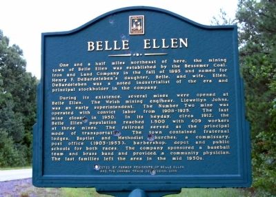
Belle Ellen
During its existence, several mines were opened at Belle Ellen. The Welsh mining engineer, Llewellyn Johns, was an early superintendent. The Number Two mine was operated with convict labor from 1908-1925. The last mine closed in 1950. In its heyday, circa 1912, the Belle Ellen population reached 1,500 with 409 workers at three mines. The railroad served as the principal mode of transportation. The town contained fraternal lodges, Baptist and Methodist churches, a commissary, post office (1903-1953), barber shop, depot and public schools for both races. The company sponsored a baseball team and brass band and provided a community physician. The last families left the area in the mid 1950s.
Erected 2000 by Former Residents of Belle Ellen & The Cahaba Trace Commission.
Topics. This historical marker is listed in this topic list: Industry & Commerce. A significant historical year for this entry is 1895.
Location. 33° 6.947′ N, 87° 4.98′ W. Marker is in West Blocton, Alabama, in Bibb County. Marker is on Cahaba River Drive (County Road 24), on the right when traveling north. Touch for map. Marker is in this post office area: West Blocton AL 35184, United States of America. Touch for directions.
Other nearby markers. At least 8 other markers are within 9 miles of this marker, measured as the crow flies. Welcome to West Blocton Coke Ovens Park (approx. 1.4 miles away); Blocton / Blocton Coke Ovens (approx. 1.4 miles away); What Are Coke Ovens? (approx. 1.4 miles away); The Railway System (approx. 1˝ miles away); West Blocton, Alabama (approx. 1.8 miles away); Piper / Coleanor (approx. 3.1 miles away); Town of Woodstock (approx. 8 miles away); Six Mile Male & Female Academy Site (approx. 8.7 miles away). Touch for a list and map of all markers in West Blocton.
Also see . . . Marvel, A Coal Mining Town in the Cahaba Coal Fields. (Submitted on January 12, 2011.)
Credits. This page was last revised on June 16, 2016. It was originally submitted on October 24, 2010, by Julia Frost of Hoover, Alabama. This page has been viewed 1,932 times since then and 111 times this year. Photo 1. submitted on October 24, 2010, by Julia Frost of Hoover, Alabama. • Kevin W. was the editor who published this page.
